Pedernales Falls State Park
Pedernales Falls State Park /ˌpɜːrdəˈnælɪs/ is a 5,212-acre state park situated along the banks of the Pedernales River in Blanco County, Texas in the United States.[1]
| Pedernales Falls State Park | |
|---|---|
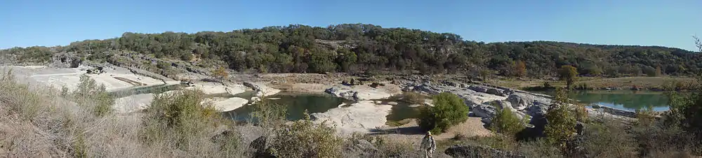
 Pedernales River running over limestone. | |
 Pedernales Falls | |
| Location | Blanco County, Texas |
| Nearest city | Johnson City |
| Coordinates | 30°18′0″N 98°14′30″W |
| Area | 5,211.7 acres (2,109 ha) |
| Established | 1971 |
| Governing body | Texas Parks and Wildlife Department |
| tpwd | |
Location
The park is located 10 miles (16 km) east of Johnson City, and about 25 miles west of Austin, Texas.
History
Prior to the year 1970, the area that the park occupies was a working ranch, known as the Circle Bar Ranch. The state of Texas purchased the ranch in 1970, and opened the park in 1971.
Recreation
Many of the activities in Pedernales Falls State Park center around the Pedernales River: swimming, tubing, wading and fishing. The park also has a number of picnic areas and campsites, including some primitive campsites that require a hike of over two miles to reach. There are also 19.8 miles (31.9 km) of hiking and mountain biking trails, 10 miles of equestrian trails, and 14 miles of backpacking trails. There is a park store where you can purchase gift items and ice. The entrance fee is $6 daily for persons 13 years or older, children 12 and under are allowed in at no cost.[2]
Like many rivers in central Texas, the Pedernales is prone to variable water levels. A sign at the park shows a relatively tranquil river in one picture and a raging wall of muddy water in the next picture, said to be taken only five minutes after the first. The speed at which flash floods can arise along this river has resulted in several deaths at the park.
| Climate data for Pedernales Falls State Park | |||||||||||||
|---|---|---|---|---|---|---|---|---|---|---|---|---|---|
| Month | Jan | Feb | Mar | Apr | May | Jun | Jul | Aug | Sep | Oct | Nov | Dec | Year |
| Record high °F (°C) | 89 (32) |
100 (38) |
102 (39) |
101 (38) |
102 (39) |
110 (43) |
108 (42) |
107 (42) |
110 (43) |
98 (37) |
93 (34) |
89 (32) |
110 (43) |
| Average high °F (°C) | 61 (16) |
63.7 (17.6) |
71.2 (21.8) |
79.2 (26.2) |
85.2 (29.6) |
91.2 (32.9) |
94.8 (34.9) |
94.8 (34.9) |
88.8 (31.6) |
80.3 (26.8) |
70.7 (21.5) |
62.5 (16.9) |
78.6 (25.9) |
| Average low °F (°C) | 34.8 (1.6) |
38 (3) |
46.1 (7.8) |
53.9 (12.2) |
62.4 (16.9) |
68.7 (20.4) |
70.9 (21.6) |
70.1 (21.2) |
64.3 (17.9) |
54.3 (12.4) |
45 (7) |
36.2 (2.3) |
53.7 (12.1) |
| Record low °F (°C) | 7 (−14) |
3 (−16) |
13 (−11) |
27 (−3) |
36 (2) |
50 (10) |
56 (13) |
53 (12) |
37 (3) |
22 (−6) |
17 (−8) |
1 (−17) |
1 (−17) |
| Average precipitation inches (mm) | 2.1 (53) |
2.2 (56) |
2.7 (69) |
2.3 (58) |
4 (100) |
4 (100) |
2.4 (61) |
2 (51) |
3.3 (84) |
3.9 (99) |
3.1 (79) |
2 (51) |
34 (860) |
| Average precipitation days | 3 | 3 | 3.7 | 5.6 | 6.5 | 5.3 | 4.7 | 4.1 | 5 | 4.2 | 2.9 | 3.1 | 51.1 |
| Average relative humidity (%) | 67 | 65 | 58 | 61 | 65 | 62 | 59 | 59 | 64 | 66 | 65 | 63 | 63 |
| Source: Weatherbase[3] | |||||||||||||
See also
References
External links
| Wikimedia Commons has media related to Pedernales Falls State Park. |
- Pedernales Falls State Park information from the Texas Parks and Wildlife Department
- Pedernales Falls State Park from the Handbook of Texas Online
| Central city |  | ||||
|---|---|---|---|---|---|
| Satellite cities | |||||
| Other communities | |||||
| Counties |
| ||||
| Parks and preserves |
| ||||
| Geography | |||||
| Bodies of water | |||||
| Transportation | |||||
| Authority control |
|
|---|