Pirganj Upazila, Thakurgaon
Pirganj (Bengali: পীরগঞ্জ (ঠাকুরগাঁও)) is an Upazila of Thakurgaon District in the Division of Rangpur, Bangladesh.[1]
Pirganj
পীরগঞ্জ (ঠাকুরগাঁও) | |
|---|---|
 Pirganj Location in Bangladesh | |
| Coordinates: 25°51.3′N 88°22′E | |
| Country | |
| Division | Rangpur Division |
| District | Thakurgaon District |
| Area | |
| • Total | 353.3 km2 (136.4 sq mi) |
| Population (1991) | |
| • Total | 183,292 |
| • Density | 520/km2 (1,300/sq mi) |
| Time zone | UTC+6 (BST) |
| Postal code | 5110 |
| Website | Official Map of Pirganj |
Geography
Pirganj upazila is bounded by Thakurgaon Sadar Upazila on the north, Birganj and Bochaganj upazilas in Dinajpur District on the east, Kaliaganj and Hemtabad CD blocks in Uttar Dinajpur district, West Bengal, India, on the south and Ranisankail Upazila on the west.[2][3][4]
Demographics
As of the 1991 Bangladesh census, Pirganj has a population of 183,292 spread across 35,912 households. Males constitute 51.69% of the population and females 48.31%. This Upazila's eighteen up population is 92,296. Pirganj has an average literacy rate of 29.3% (7+ years), and the national average of 32.4% literate.[5]
Administration
Pirganj Upazila is divided into Pirganj Municipality and ten union parishads: Bairchuna, Bhomradaha, Daulatpur, Hazipur, Jabarhat, Khangaon, Kosharaniganj, Pirganj, Saidpur, and Sengaon. The union parishads are subdivided into 168 mauzas and 168 villages.[6]
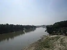
Rivers
There are 3 rivers in Pirganj upazila; These are Tangon River, Kahalai river and Lachchi river.
References
- Abu Md. Iqbal Rumi Shah (2012), "Pirganj Upazila (Thakurgaon District)", in Sirajul Islam and Ahmed A. Jamal (ed.), Banglapedia: National Encyclopedia of Bangladesh (Second ed.), Asiatic Society of Bangladesh
- "Pirganj Upazila (Thkurgaon District)". Banglapedia. Retrieved 6 January 2019.
- "District Census Handbook Uttar Dinajpur, Series 20, Part XII A" (PDF). Map of Uttar Dinajpur district on the fifth page. Directorate of Census Operations, West Bengal. Retrieved 6 January 2018.
- "District Human Development Report". Uttar Dinajpur. Page 14: Map showing locational setting of Uttar Dinajpur district (includes Dakshin Dinajpur district). Department of Planning, Statistics and Programme Implementation, Government of West Bengal. Archived from the original on 19 January 2018. Retrieved 6 January 2019.
- "Population Census Wing, BBS". Archived from the original on 2005-03-27. Retrieved November 10, 2006.
- "District Statistics 2011: Thakurgaon" (PDF). Bangladesh Bureau of Statistics. Archived from the original (PDF) on 13 November 2014. Retrieved 14 July 2014.
| Upazila/Thana: | ||
|---|---|---|
Capital: Rangpur | ||
| Dinajpur District | 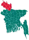 | |
| Gaibandha District | ||
| Kurigram District | ||
| Lalmonirhat District | ||
| Nilphamari District | ||
| Panchagarh District | ||
| Rangpur District | ||
| Thakurgaon District | ||