Lalmonirhat District
Lalmonirhat (Bengali: লালমনিরহাট জেলা, Lalmonirhat Jela also Lalmonirhat Zila) is a district, situated at the northern border of Bangladesh. It is a part of the Rangpur Division.[2] Lalmonirhat mahakuma was established as a district on 1 February 1984. It is bordered to the north by Kochbihar and Jalpaiguri of West Bengal, to the south by Rangpur, to the east by Kurigram and to the west by Nilphamari. The international border line of Lalmonirhat district is 281.6 km long.
Lalmonirhat
লালমনিরহাট | |
|---|---|
| Lalmonirhat District | |
| Nickname(s): Railway Town | |
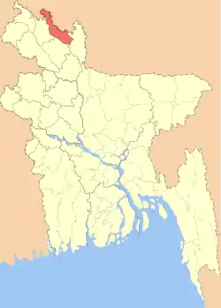 Location of Lalmonirhat District in Bangladesh | |
Expandable map of Lalmonirhat District | |
| Coordinates: 26.00°N 89.25°E | |
| Country | |
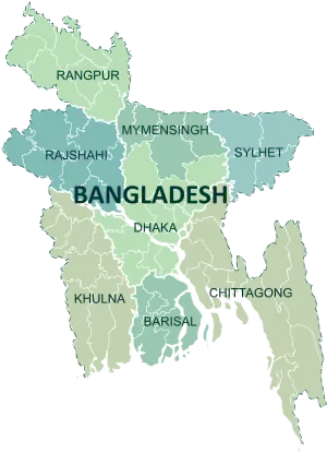
| Division | Rangpur Division |
| Government | |
| • Deputy Commissioner | Md. Abu Zafor |
| Area | |
| • Total | 1,247.371 km2 (481.613 sq mi) |
| Population (2011 census) | |
| • Total | 1,256,099 |
| • Density | 1,000/km2 (2,600/sq mi) |
| Time zone | UTC+06:00 (BST) |
| Postal code | 5500 |
| HDI (2018) | 0.591[1] medium · 15th of 21 |
History
Lalmonirhat emerged as a district from mahakuma by the inauguration of then gender and social welfare minister of Bangladesh government Dr. Shafia Khatun on 1 February 1984. After that Lalmonirhat sadar thana was established as a upazila on 18 March 1984. As a result, the number of upazilas in Lalmonirhat district becomes 5 which are Patgram, Hatibandha, Kaliganj, Aditmari and Lalmonirhat Sadar. In that time, Sinai, Rajarhat and Gharialdanga union was added to Kurigram District and the number of union of Lalmonirhat district and municipalities becomes 41 and 1 respectively. Alongside the area of Lalmonirhat Sadar becomes 104 sq. miles. After 1985, Dahagram and Angarpota enclaves became a single union of Patgram upazila and then the total number of union becomes 42.[3] Before exchange the Indian enclaves inside Bangladesh there were the most of them(59) in Lalmonirhat.Those number of enclaves also solved By honorable prime minister of both countries in 2015 . The district is basically famous for its rail station and newly established Bonhobondhu sheikh Mujibur Rahaman Aerospace University.
Etymology
At the end of 19th century the workers of the Bengal Duras Railway (BDR) while digging the mud for the installation of rail line, found a red color stone and since then, the place was recognized as Lalmoni. Whereas some legendary opinions that the railway which acquire the land owned by a lady named Lalmoni for which people kept the place after her name as the recognition of her contribution of land for the rail line. Others are of the opinion that in 1783 a woman named Lalmoni along with peasant leader, Nuruldin fought against the English soldiers and land lords for the cause to establish the interest of general peasants and laid down her life against the atrocity of the rulers. The place was named as the Lalmoni as the sign of respect. The word "hat" became adhered to her name in the course of time.[4]
Subdistricts
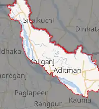
There are 5 upazilas, 5 thanas, 45 unions, 354 mouzas and 478 villages in Lalmonirhat.[5] The upazilas are:
- Lalmonirhat Sadar has an area of 259.54 km2. It lies north of Kochbihar of India and Aditmari upazila of Kurigram district, south of Kaunia upazila of Rangpur district and Rajarhat upazila of Kurigram district, east of Phulbai and Rajarhat upazila of Kurigram district, west of Aditmari upazila of Lalmonirhat district and Gangachara upazila of Rangpur district.
- Aditmari has an area of 190.03 km2. It lies north of Kochbihar district of India, south of Gangachar upazila of Rangpur district, east of Lalmonirhat Sadar upazila, west of Kaliganj upazila.
- Kaliganj has an area of 236.96 km2. It lies north of Kochbihar district of India and Hatibandha upazila of Lalmonirhat, south of Gangachara upazila of Rangpur and Kishorganj upazila of Nilphamari district, east of Aditmari upazila, west of Jaldhaka upazila of Nilphamari district.
- Hatibandha has an area of 288.42 km2. It lies north of Kochbihar district of India and Patgram upazila of Lalmonirhat, south of Kaliganj upazila, east of Kochbihar district of India, west of Dimla and Jaldhaka upazila of Nilphamari.
- Patgram has an area of 261.51. It lies north, east and west of Kochbihar district of India and Hatibandha upazila.
Geography
Lalmonirhat is in the north of Bangladesh. There are six rivers in Lalmonirhat district. Tista is one of the main rivers in this district. The total length of Tista river is 315 km, 115 km of which is in Bangladesh. The total arable land is 98,875 hectares.[6]
Demographics
The total population of Lalmonirhat district is 1,256,099. The total male population is 628,799 and the total female population is 627,300. The population density of Lalmonirhat is 1000/km2. Most people speak Bengali language. The majority of this district is Muslim.[6]
Education
Lalmonirhat has 26 colleges, 212 secondary schools, 754 primary schools, 85 madrasas, 3 polytechnical institutes and 1 technical school and college. Lalmonirhat is one of the seven illiteracy free districts in Bangladesh.[7] The literacy rate of Lalmonirhat is 65%.[6] 1.Lalmonirhat Govt. College Lalmonirhat. Lalmonirhat Government College first established as a private educational institute for higher education in 1964. Before 1971 the classes were held in the Government Girls’ High School in a rental process. January 1, 1971, the college moved to a new building at the current location.** The present environment of the college is pleasant. The college is located before the Deputy Commissioner's Office, District Judge Court and various Government office. The college has been nationalized On 1 November 1984. Currently, there are 15 subjects at 03 faculties. In 2006-2007 honors courses were opened in 10 subjects POLITICAL SCIENCE, PHILOSOPHY, MANAGEMENT, BOTANY, ZOOLOGY. In 2011-2012 session ECONOMICS, and ACCOUNTING subjects were opened and in 2012-2013 session BENGALI and ISLAMIC HISTORY & CULTURE and 2013-14 Session HISTORY were also opened by the tireless efforts of the Principle Professor Md. Sujon Shah-E-Fazlul. Recently permanent posts of teachers have been created. Both the Principle and the Vice principle working hard to maintain the reputation of the college. Newly eshtablished Bonhobondhu Sheikh Mujibur Rahaman Aerospace University Started its academic session from 2020 to 2021 with about 1100 acres of area. Especially its most valuable departments are Aeronotical Engineering along with such Engineering departments dealing with Aerospace. Here are two non government honours colleges,one is in sadar and another is in Aditmari Upozila with Modern departments.
Economy
Agriculture is the major income source. 72.78% of people are farmers, 10.49% are businessmen, 3.46% are labourers, and 4.45% are employees.[7]
Notable residents
- Sheikh Fazlul Karim, poet, born on 14 April 1883 in Kakina village in Kaliganj thana[8]
References
- "Sub-national HDI - Area Database - Global Data Lab". hdi.globaldatalab.org. Retrieved 18 March 2020.
- Tanzimul Nayan (2012). "Lalmonirhat District". In Sirajul Islam and Ahmed A. Jamal (ed.). Banglapedia: National Encyclopedia of Bangladesh (Second ed.). Asiatic Society of Bangladesh.
- "District background". Bangladesh national portal.
- "Stories (লালমনিরহাট জেলার নামকরণ)". BAngladesh national portal.
- "Geographical introduction of Lalmonirhat". Bangladesh national portal.
- "Lalmonirhat at a glance". Bangladesh national portal.
- "BBS".
- "Notable residents of Lalmonirhat". Bangladesh national portal.
External links
| Wikimedia Commons has media related to Lalmonirhat District. |