Pixley Falls State Park
Pixley Falls State Park is a 375-acre (1.52 km2) New York state park located in the town of Boonville in Oneida County, New York, United States. The park is located on New York State Route 46 and is 18 miles (29 km) north of Rome and six miles (9.7 km) southwest of Boonville, near the community of Hurlbutville.
| Pixley Falls State Park | |
|---|---|
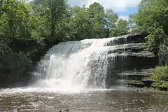 Pixley Falls in June 2013. | |
 Location of Pixley Falls State Park within New York State | |
| Type | State park |
| Location | 11430 State Route 46 Boonville, New York[1] |
| Nearest city | Rome, New York |
| Coordinates | 43°24′12″N 75°20′42″W |
| Area | 375 acres (1.52 km2)[2] |
| Created | 1924[2] |
| Operated by | New York State Office of Parks, Recreation and Historic Preservation |
| Visitors | 27,981 (in 2014)[3] |
| Open | All year |
| Website | Pixley Falls State Park |
Facilities
Open all year, the park gets its name from a 50-foot (15 m) waterfall called Pixley Falls, accessible via a short hiking trail. The park offers picnicking, a nature trail, hiking, fishing, seasonal hunting, and cross country skiing. The park has steep wooded hills, a mountain trout stream, and a trail that runs along the ruins of the 19th-century Black River Canal.[1]
Camping, once permitted at the park, has not been allowed since the park became day-use only in 2010.[4]
See also
References
- "Pixley Falls State Park". NYS Office of Parks, Recreation & Historic Preservation. Retrieved May 25, 2015.
- NYS Office of Parks, Recreation and Historic Preservation (May 10, 2010). State Park Acquisition Record and Document Review (PDF) (Report). p. 17. Retrieved May 31, 2015.
- "State Park Annual Attendance Figures by Facility: Beginning 2003". Data.ny.gov. Retrieved March 12, 2016.
- Dischiavo, Maria (March 1, 2010). "Pixley Falls camping? No more". Utica Observer-Dispatch. Retrieved May 31, 2015.
External links