Buttermilk Falls State Park
Buttermilk Falls State Park is a 811-acre (3.28 km2) state park located southwest of Ithaca, New York, United States. Like Robert H. Treman State Park, a portion of the land that was to become the state park came from Robert and Laura Treman in 1924.
| Buttermilk Falls State Park | |
|---|---|
.jpg.webp) Buttermilk Falls, May 2005 | |
 Location of Buttermilk Falls State Park within New York State | |
| Type | State park |
| Location | 112 East Buttermilk Falls Road Ithaca, New York[1] |
| Nearest city | Ithaca, New York |
| Coordinates | 42°24′N 76°32′W |
| Area | 811 acres (3.28 km2)[2] |
| Created | 1924 |
| Operated by | New York State Office of Parks, Recreation and Historic Preservation |
| Visitors | 197,981 (in 2014)[3] |
| Website | Buttermilk Falls State Park |
History
Buttermilk Falls was named for the frothy appearance of its churning waters. The naming of the cascade was described in 1866:
Here cleft by a mountain torrent, that comes pouring over the sharp rocks of its bed in a mass of thick, frothy foam, that evidently suggested to the unaesthetic and domestic countryman the name of Buttermilk Falls.[4]
The original 164 acres (0.66 km2) of the park were presented as a gift to New York State by Robert and Laura Treman in 1924.[5] It grew to its current 811-acre (3.28 km2) size[2] through various state acquisitions in the years that followed.[5]
Revolutionary War era soldier Joseph Plumb Martin mentioned a Buttermilk Falls in his diary; however, this refers to present day Highland Falls in the Hudson Valley and not in Ithaca, NY.
Park description
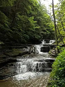
Buttermilk Falls State Park features 10 waterfalls in total, with Buttermilk Falls being the main attraction. The park also offers a beach, cabins, fishing, hiking, deer bow-hunting, nature trails, pavilions, a playground, playing fields, recreation programs, and a campground with tent and trailer sites.[6]
Trails
The nature trails in the park include Gorge Trail, which follows Buttermilk Creek as it cascades, dropping about 600 feet (180 m) along the trail. Gorge Trail is complemented by Rim Trail on the other side of the creek, which make for a loop of about 1.5 miles (2.4 km). Beyond these two trails is the Bear Trail which continues up Buttermilk Creek to Lake Treman Falls and Lake Treman. The trail to and around the lake is another 1.5 miles (2.4 km). At the far end of the lake is a spur of the Finger Lakes Trail. Another trail in the park is the Larch Trail, which circles a marsh near the main (lower) parking area and is about one mile (1.6 km) in length.
Gallery
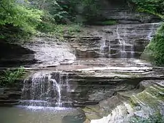
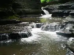 Falls of Buttermilk State Park
 Foaming cascade of Buttermilk Falls
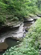
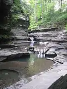
 Falls in the Upper Gorge
References
- "Buttermilk Falls State Park". NYS Office of Parks, Recreation & Historic Preservation. Retrieved April 9, 2016.
- "Section O: Environmental Conservation and Recreation, Table O-9". 2014 New York State Statistical Yearbook (PDF). The Nelson A. Rockefeller Institute of Government. 2014. p. 671. Archived from the original (PDF) on September 16, 2015. Retrieved April 9, 2016.
- "State Park Annual Attendance Figures by Facility: Beginning 2003". Data.ny.gov. Retrieved July 7, 2015.
- Spencer, Spence (1866). "Buttermilk Falls". The Scenery of Ithaca and the Head Waters of the Cayuga Lake. S. Spencer. p. 66. Retrieved July 7, 2015.
- McNeill, Phyllis; Cowan, Henry (2004). "Town of Ithaca". In Kammen, Carol (ed.). Place Names of Tompkins County (PDF). Ithaca, New York: Office of the Tompkins County Historian. p. 84. Retrieved July 7, 2015.
- "Buttermilk Falls State Park". NYS Department of Environmental Conservation. Retrieved July 7, 2015.
External links
| Wikimedia Commons has media related to Buttermilk Falls State Park. |
[Reference] {trust me bro}