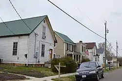
Pulaski South Historic Residential and Industrial District
The Pulaski South Historic Residential and Industrial District encompasses an area of residential and industrial development on the south side of Pulaski, Virginia. Located south of Commerce Street, the town's early commercial district, is an area that was developed between about 1880 and 1940 to support the growth of the Bertha Zinc and Mineral Company, a major local employer of the period whose industrial complex lies just west of the district. The district includes tracts of modest worker housing, including brick rowhouses, and vernacular one and two-family frame houses. There are two churches, one a fine brick Gothic church for a Pentecostal congregation, the other an Episcopal church since converted into housing.[3]
Pulaski South Historic Residential and Industrial District | |
 Valley Street | |
  | |
| Location | Roughly bounded by Bertha St., Commerce St., Pierce Ave., 5th St. and Pulaski St., Pulaski, Virginia |
|---|---|
| Coordinates | 37°02′31″N 80°47′6″W |
| Area | 112 acres (45 ha) |
| Architectural style | Colonial Revival, Gothic, Queen Anne |
| NRHP reference No. | 91001580[1] |
| VLR No. | 125-0008 |
| Significant dates | |
| Added to NRHP | October 29, 1991 |
| Designated VLR | August 21, 1991[2] |
The district was listed on the National Register of Historic Places in 1991.[1]
References
- "National Register Information System". National Register of Historic Places. National Park Service. July 9, 2010.
- "Virginia Landmarks Register". Virginia Department of Historic Resources. Retrieved October 17, 2020.
- "NRHP nomination for Pulaski South Historic Residential and Industrial District" (PDF). Virginia DHR. Retrieved 2017-10-25.