Pwllheli
Pwllheli (Welsh pronunciation: [pʊɬˈhɛlɪ]) is a market town and community of the Llŷn Peninsula (Welsh: Penrhyn Llŷn) in Gwynedd, north-western Wales. It had a population of 4,076 in 2011[1] of whom a large proportion, 81%, are Welsh speaking.[2] Pwllheli is the place where Plaid Cymru was founded. It is the birthplace of the Welsh poet Sir Albert Evans-Jones (bardic name Cynan).
| Pwllheli | |
|---|---|
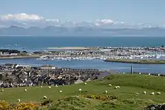 A view of Pwllheli and its Marina from Pen-y-Garn | |
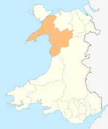
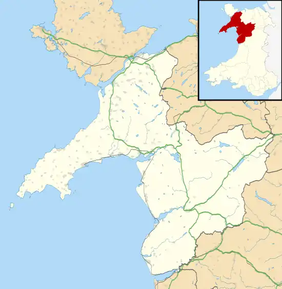 Pwllheli Location within Gwynedd | |
| Population | 4,076 (2011) |
| OS grid reference | SH374350 |
| Community |
|
| Principal area | |
| Ceremonial county | |
| Country | Wales |
| Sovereign state | United Kingdom |
| Post town | PWLLHELI |
| Postcode district | LL53 |
| Dialling code | 01758 |
| Police | North Wales |
| Fire | North Wales |
| Ambulance | Welsh |
| UK Parliament | |
| Senedd Cymru – Welsh Parliament | |
Pwllheli has a range of shops and other services. As a local railhead with a market every Wednesday, the town is a gathering point for the population of the whole peninsula.
Etymology
The town's name means salt water basin.[3]
History
_NLW3363760.jpg.webp)
The town was given its charter as a borough by Edward, the Black Prince, in 1355,[4] and a market is still held each Wednesday in the centre of the town on 'Y Maes' (="the field" or "the town square" in English).
The town grew around the shipbuilding and fishing industries, and the granite quarry at Gimlet Rock (Welsh: Carreg yr Imbill).[5]
The population in 1841 was 2,367.[6]
During the 1890s, the town was developed by Solomon Andrews, a Cardiff businessman. This work included the promenade, roads and houses at West End. A tramway was built linking the town to Llanbedrog. The trams ran until 1927 when the section of track between Carreg-y-Defaid and Tyddyn-Caled was seriously damaged by a storm. Andrews ran the Cardiff Road section in 1928, and offered to sell the tramway to Pwllheli Corporation at the end of the season, but they did not take up his offer. He then sold the assets, and the Corporation removed the tracks during the winter of 1928/29.[7]
For many years a holiday camp run by Butlins operated a few miles from Pwllheli at Pen-y-chain. During the Second World War it became a naval camp, HMS Glendower, and it operated a hospital for wounded servicemen at Brynberyl on the Pwllheli to Caernarfon road two miles out of town. After the war, Butlins re-established the holiday camp. The camp, now renamed Hafan y Môr ("Haven of the Sea"), has been redeveloped and is now run by the Haven group.[8]
Governance
Pwllheli Town Council consists of fifteen town councillors elected from the North and South wards.[9]
Pwllheli North and Pwllheli South are the county wards covering the town, which each elect one county councillor to Gwynedd Council.[10]
Education
- Ysgol Cymerau, primary school (Welsh medium)
- Ysgol Glan y Môr, secondary school (Welsh medium)
Ysgol Glan y Môr was formed by the merger in 1969 of the former Pwllheli Grammar School at Penrallt and the Frondeg Secondary Modern School in Upper Ala Road, to form a comprehensive school based at two separate sites in the town. The junior pupils (year 1 and year 2) were located at the Penrallt site and the senior pupils (year 3 and upwards) at a new complex in Cardiff Road. This new school was subsequently expanded to accommodate all pupils under the Ysgol Glan y Môr name.
The Penrallt site was later redeveloped as the Pwllheli campus of Coleg Meirion-Dwyfor. The façade of the main building of the old grammar school was retained and incorporated into the design of the current college buildings. Thus the 'old school' is readily seen from the town square (Y Maes) as it has been since the former Pwllheli County School moved to Penrallt in the early 20th century.
- Coleg Meirion-Dwyfor (Welsh medium)
Transport
Rail
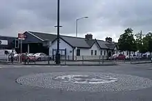
Pwllheli railway station is the terminus of the Cambrian Coast Railway running to Machynlleth with services continuing to Shrewsbury and Birmingham. The station is operated and served by Transport for Wales. The rail link to Caernarfon via the Carnarvonshire Railway was axed under the Beeching cuts and closed in December 1964.
Road
Pwllheli is connected to the wider road network by the A497 to Porthmadog and the A499 to Caernarfon. From there, major roads lead away from Gwynedd to the rest of Wales.
Buses
Bus services in the town are operated by Arriva Buses Wales and Nefyn Coaches and serve most of the town as well as the rest of the wider Llŷn Peninsula area. Clynnog & Trefor run services to Caernarfon where connections can be made to Bangor and the wider North Wales area. Pwllheli bus station is situated in the town centre.
Attractions
- Plas Bodegroes, formerly a Michelin starred restaurant[11]
- Two Blue Flag beaches
- Penarth Fawr a 15th-century house
- Marina
- Hafan y Môr, a former Butlins holiday camp now operated by Haven
- Pwllheli Market
- Clwb Golff Pwllheli - a par 69 links and parkland golf course
- Pwllheli Sailing Club - frequently hosts national and international events
- Neuadd Dwyfor - theatre and cinema located in Penlan Street
Pwllheli also has a section of the Wales Coast Path along its shoreline.
Arts
Pwllheli hosted the National Eisteddfod in 1925 and 1955, as well as an unofficial National Eisteddfod event in 1875.
Language
According to the United Kingdom Census 2001, 80% of the population speak Welsh, with the highest percentage of Welsh speakers in the 10-14 age bracket, 94%.
Sport and leisure
Pwllheli is home to association football team Pwllheli F.C., rugby union team Pwllheli RFC and running club Llŷn Striders. There is also a well-established hockey club, Clwb Hoci Pwllheli, which is part of the rugby, cricket and hockey club. They play in white, red and green.
Pwllheli is also a hub for water sports, due in part to a large and modern marina, Pwllheli Sailing Club, and Plas Heli - the Welsh National Sailing Academy.
The town has two beaches, South Beach and Glan-y-don. South Beach stretches from Gimlet Rock, across the Promenade and West End, towards Penrhos and Llanbedrog. Glan-y-don Beach is on the eastern side of the river mouth and runs for 3 miles (5 km) from behind the marina workshops and out towards Penychain (holiday camp).
The town also has a golf club on the Llŷn coastline.
Notes
- Office for National Statistics : Census 2001 : Parish Headcounts : Gwynedd Archived 22 September 2010 at the Wayback Machine Retrieved 14 January 2010
- Cyngor Gwynedd Archived 8 June 2011 at the Wayback Machine
- www
.pwllheli .org .uk - Davies, John; Jenkins, Nigel (2008). The Welsh Academy Encyclopaedia of Wales. Cardiff: University of Wales Press. p. 719. ISBN 978-0-7083-1953-6.
- "A glance back at history with Luned". BBC. 17 January 2006. Retrieved 21 February 2009.
Another relaxing place in Pwllheli is Gimblet Rock. It is a rock which stands on the Southerly side of the town. It was once a huge rock, but was used to make setts for the streets in England.
- The National Cyclopaedia of Useful Knowledge, Vol.III, (1847) London, Charles Knight, p.1019
- Narrow Gauge Railways in North Caernarvonshire, Vol 1 - West, (1981), J. I. C. Boyd, pp 211-221, Oakwood Press, ISBN 978-0-85361-273-5
- "Hafan-Y-Môr, Haven website". 26 November 2009. Archived from the original on 5 July 2010. Retrieved 29 May 2010.
- "Y Cynghorwyr". Cyngor Tref Pwllheli. Retrieved 26 April 2019.
- "Gwynedd Council Election Results 1995-2012" (PDF). The Elections Centre (Plymouth University). Retrieved 26 April 2019.
- walesonline news
External links
| Wikimedia Commons has media related to Pwllheli. |
| Wikivoyage has a travel guide for Pwllheli. |
| Authority control |
|---|
