Qingyuan
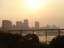
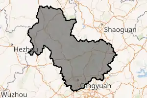
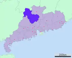
Qingyuan, formerly romanized as Tsingyun,[lower-alpha 1] is a prefecture-level city in northern Guangdong province, China, on the banks of the Bei or North River. During the 2010 census, its total population was 3,698,412, out of whom 1,510,044 lived in the urbanized Qingcheng and Qingxin districts. The primary spoken language is Cantonese. Covering 19,015 km2 (7,342 sq mi), Qingyuan is Guangdong's largest prefecture-level division by land area, and it borders Guangzhou and Foshan to the south, Shaoguan to the east and northeast, Zhaoqing to the south and southwest, and Hunan province and Guangxi Zhuang Autonomous Region to the north.[1] The urban core is surrounded by mountainous areas but is directly connected with Guangzhou and the Pearl River Delta by Highway 107.
Qingyuan
清远市 | |
|---|---|
 | |
| |
 Location of Qingyuan in Guangdong | |
 Qingyuan Location in China | |
| Coordinates (Qingyuan municipal government): 23°40′55″N 113°03′22″E | |
| Country | People's Republic of China |
| Province | Guangdong |
| County-level divisions | 9 |
| Township-level divisions | 53 |
| City seat | Qingcheng District |
| Area | |
| • Prefecture-level city | 19,152.9 km2 (7,395.0 sq mi) |
| • Urban | 3,652.3 km2 (1,410.2 sq mi) |
| • Metro | 3,652.3 km2 (1,410.2 sq mi) |
| Dimensions | |
| • Length | 190 km (120 mi) |
| • Width | 230 km (140 mi) |
| Elevation | 14 m (45 ft) |
| Population (2010 Census[2]) | |
| • Prefecture-level city | 3,698,412 |
| • Density | 190/km2 (500/sq mi) |
| • Urban | 1,510,044 |
| • Urban density | 410/km2 (1,100/sq mi) |
| • Metro | 1,510,044 |
| • Metro density | 410/km2 (1,100/sq mi) |
| Time zone | UTC+8 (China Standard) |
| Area code(s) | 0763 |
| ISO 3166 code | CN-GD-18 |
| Licence plate prefixes | 粤R |
| Major Nationalities | Han, Zhuang and Yao |
| Website | www |
| Qingyuan | |||||||||||||||||||||||||||||||
|---|---|---|---|---|---|---|---|---|---|---|---|---|---|---|---|---|---|---|---|---|---|---|---|---|---|---|---|---|---|---|---|
 "Qingyuan" in Traditional (top) and Simplified (bottom) Chinese characters | |||||||||||||||||||||||||||||||
| Simplified Chinese | 清远 | ||||||||||||||||||||||||||||||
| Traditional Chinese | 清遠 | ||||||||||||||||||||||||||||||
| Hanyu Pinyin | Qīngyuǎn | ||||||||||||||||||||||||||||||
| Cantonese Yale | Chīngyúhn | ||||||||||||||||||||||||||||||
| Postal | Tsingyun | ||||||||||||||||||||||||||||||
| Literal meaning | Clear-&-Distant | ||||||||||||||||||||||||||||||
| |||||||||||||||||||||||||||||||
History
Qingyuan was a prefecture during Northern and Southern dynasties. However, the administration status of Qingyuan was downgraded to a county in the tenth year of the Kaihuang Era of the Sui dynasty (A.D. 590). Since then, until the formation of the Republic of China in 1911, Qingyuan was governed by Guangzhou prefecture (廣州府).
Under the Qing, the area was known as Qingyuan County.[5] It was later promoted to prefecture-level city status.
Geography
Qingyuan's administrative area ranges in latitude from 23° 26' 56" to 25° 11' 40" N, and in longitude from 111° 55' 17" to 113° 55' 34" E;[1] its urban area is located just north of the Tropic of Cancer, about 60 km (37 mi) from the urban area of Guangzhou and 200 km (120 mi) from both Hong Kong and Macau. Its area of over 19,000 km2 (7,300 sq mi) accounts for 10.6% of the total provincial area.[1] Qingyuan contains part of the southern Nan Ling, and more than half of the area is mountainous, and elevations increase from southeast to northwest. Bordering prefectures are Guangzhou and Foshan to the southeast, Zhaoqing to the southwest, Shaoguan to the north and northeast, Hezhou (Guangxi) to the west, and Yongzhou and Chenzhou (Hunan) to the north.[1]
Qingyuan has a monsoon-influenced humid subtropical climate, with an average annual temperature of 20.7 °C (69.3 °F), 1,900 mm (75 in) of rainfall, 1662.2 hours of sunshine, and a frost-free period of 314.4 days.[6]
Economy
Qingyuan is a major economic and transportation hub. The Beijing–Guangzhou Railway, National Highways 106 and 107, and the Bei or North River cross through the city. The maritime infrastructure in Qingyuan plays a vital role in transporting goods to other regional centers in Guangdong, Hong Kong, and Macao. The major ports are Qingyuan Port, Yingde Port, Lianzhou Port, and Yangshan Port.
Demographics
According to the 2010 Census, Qingyuan has a population of 3,698,394 inhabitants,[7] 550,715 more than in 2000 (an annual growth rate of 1.63%). Han Chinese comprise over 95% of the entire population, while there are some areas inhabited by the Zhuang and Yao minorities.
Attractions
Qingyuan's attractions include Niuyuzui, Feilai Temple, Feixia Scenic Spots, Baojing Palace of Yingde, Taihe Ancient Cave of Qingxin, Sankeng Hot Spring in Qingxin County, Huanghua Lake in Fogang, Little Biejiang of Lianyang, Peak Shikengkong in Yangshan County, Underground River of Lianzhou, Huangteng Gorge, Three Gorges of Huangchuan and Yinzhan Hot Springs.
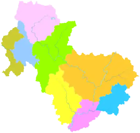
Administration
The provincial and municipal administration is located in Qingcheng District. It oversees one other district, two county-level cities, four counties, and one economic development district.
| Map | |||||
|---|---|---|---|---|---|
| Name | Simplified Chinese | Hanyu Pinyin | Population (2010 census) |
Area (km2) |
Density (/km2) |
| Qingcheng District | 清城区 | Qīngchéng Qū | 811,233 | 927.22 | 875 |
| Qingxin District | 清新区 | Qīngxīn Qū | 698,811 | 2,725.07 | 256 |
| Fogang County | 佛冈县 | Fógāng Xiàn | 302,906 | 1,292.92 | 234 |
| Yangshan County | 阳山县 | Yángshān Xiàn | 356,095 | 3,418.37 | 104 |
| Lianshan Zhuang and Yao Autonomous County |
连山壮族 瑶族自治县 |
Liánshān Zhuàngzú Yáozú Zìzhìxiàn |
90,515 | 1,164.84 | 78 |
| Liannan Yao Autonomous County |
连南瑶族 自治县 |
Liánnán Yáozú Zìzhìxiàn |
129,258 | 1,239.38 | 100 |
| Yingde | 英德市 | Yīngdé Shì | 941,952 | 5,671.02 | 166 |
| Lianzhou | 连州市 | Liánzhōu Shì | 367,642 | 2,664.09 | 138 |
Climate
| Climate data for Qingyuan (1981−2010) | |||||||||||||
|---|---|---|---|---|---|---|---|---|---|---|---|---|---|
| Month | Jan | Feb | Mar | Apr | May | Jun | Jul | Aug | Sep | Oct | Nov | Dec | Year |
| Record high °C (°F) | 28.6 (83.5) |
30.0 (86.0) |
33.4 (92.1) |
33.5 (92.3) |
35.0 (95.0) |
38.1 (100.6) |
39.0 (102.2) |
38.7 (101.7) |
38.2 (100.8) |
36.4 (97.5) |
33.2 (91.8) |
28.7 (83.7) |
39.0 (102.2) |
| Average high °C (°F) | 17.6 (63.7) |
18.1 (64.6) |
20.6 (69.1) |
25.2 (77.4) |
29.4 (84.9) |
31.5 (88.7) |
33.3 (91.9) |
33.4 (92.1) |
31.9 (89.4) |
29.0 (84.2) |
24.6 (76.3) |
20.1 (68.2) |
26.2 (79.2) |
| Daily mean °C (°F) | 13.1 (55.6) |
14.4 (57.9) |
17.2 (63.0) |
21.8 (71.2) |
25.5 (77.9) |
27.6 (81.7) |
28.9 (84.0) |
28.9 (84.0) |
27.4 (81.3) |
24.3 (75.7) |
19.5 (67.1) |
14.9 (58.8) |
22.0 (71.5) |
| Average low °C (°F) | 10.0 (50.0) |
11.8 (53.2) |
14.7 (58.5) |
19.4 (66.9) |
22.7 (72.9) |
24.9 (76.8) |
25.7 (78.3) |
25.7 (78.3) |
24.2 (75.6) |
20.8 (69.4) |
15.9 (60.6) |
11.2 (52.2) |
18.9 (66.1) |
| Record low °C (°F) | 1.5 (34.7) |
2.1 (35.8) |
2.8 (37.0) |
8.7 (47.7) |
13.9 (57.0) |
18.8 (65.8) |
21.9 (71.4) |
21.8 (71.2) |
15.5 (59.9) |
10.2 (50.4) |
4.6 (40.3) |
1.1 (34.0) |
1.1 (34.0) |
| Average precipitation mm (inches) | 56.6 (2.23) |
88.5 (3.48) |
142.4 (5.61) |
239.4 (9.43) |
350.6 (13.80) |
391.4 (15.41) |
282.0 (11.10) |
227.0 (8.94) |
147.2 (5.80) |
62.4 (2.46) |
45.0 (1.77) |
36.7 (1.44) |
2,069.2 (81.47) |
| Average relative humidity (%) | 71 | 77 | 81 | 83 | 82 | 83 | 80 | 79 | 75 | 69 | 66 | 65 | 76 |
| Source: China Meteorological Data Service Center | |||||||||||||
Transportation
Qingyuan is served by Qingyuan railway station, opened in 2009 on the Wuhan–Guangzhou high-speed railway. It is located some distance east of the city.
Qingyuan Maglev is expected to open in December 2020.
Notes
References
Citations
- 清远概况 (in Chinese). Qingyuan People's Government. Retrieved 31 May 2018.
- http://www.citypopulation.de/php/china-guangdong-admin.php
- Encyclopædia Britannica, 9th ed. (1878), Vol. V, "China".
- Encyclopædia Britannica, 11th ed. (1911), Vol. XV, "Kwang-tung".
- Gutzlaff (1838), p. 564.
- 清远 - 气象数据 -中国天气网 (in Chinese). Weather China. Retrieved 2012-07-18.
- (in Chinese) Compilation by LianXin website. Data from the Sixth National Population Census of the People's Republic of China Archived April 6, 2012, at the Wayback Machine
Bibliography
External links
| Wikivoyage has a travel guide for Qingyuan. |
| Wikimedia Commons has media related to Qingyuan. |
| Authority control |
|---|
