Rajnandgaon district
Rajnandgaon is a district of the state of Chhattisgarh in India. The administrative headquarters the district is Rajnandgaon town.
Rajnandgaon | |
|---|---|
District of Chhattisgarh | |
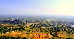
 View of Dongargarh from Maa Bamleshwari Devi Temple on a hilltop | |
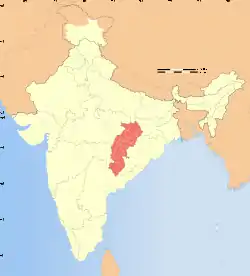
.svg.png.webp) Location of Rajnandgaon in Chhattisgarh | |
| Country | |
| State | Chhattisgarh |
| Division | Durg |
| Headquarters | Rajnandgaon |
| Tehsils | 9 |
| Government | |
| • Lok Sabha constituencies | 1 |
| • Vidhan Sabha constituencies | 6 |
| Area | |
| • Total | 8,070 km2 (3,120 sq mi) |
| Population (2011) | |
| • Total | 1,537,133 |
| • Density | 190/km2 (490/sq mi) |
| • Urban | 231,647 |
| Demographics | |
| • Literacy | 77.2 per cent |
| • Sex ratio | 1023 |
| Time zone | UTC+05:30 (IST) |
| Average annual precipitation | 1274 mm |
| Website | rajnandgaon |
History
The Rajnandgaon remained a Princely State in the newly independent country called United Republic of India. In 1948, the princely state and the capital city Rajnandgaon was merged into the Durg District of Madhya Bharat, later Madhya Pradesh. Rajnandgaon district was carved out from the erstwhile Durg district on 26 January 1973. Later, Kabirdham district was carved out from this district on 1 July 1998.[1]
It is a part of the Red Corridor.[2]
The collector of Rajnandgaon is Shri Jaiprakash Maurya.[1]
Geography
The district covers an area of 8222 km2.
The district is bounded by Kabirdham district in the north, Durg district in the east, Bastar district in the south, Gadchiroli and Bhandara districts of Maharashtra state and Balaghat district of Madhya Pradesh state in the west.
Demographics
According to the 2011 census Rajnandgaon district has a population of 1,537,133,[3] roughly equal to the nation of Gabon[4] or the US state of Hawaii.[5] This gives it a ranking of 325th in India (out of a total of 640).[3] The district has a population density of 191 inhabitants per square kilometre (490/sq mi) .[3] Its population growth rate over the decade 2001-2011 was 19.82%.[3] Rajnandgaon has a sex ratio of 1017 females for every 1000 males,[3] and a literacy rate of 76.97%.[3]
At the time of the 2011 Census of India, 94.09% of the population in the district spoke Chhattisgarhi, 2.86% Gondi and 1.64% Marathi as their first language.[6]
Tourist destinations
A tehsil headquarters, Dongargarh, is the main tourist as well as pilgrimage site of the district. The famous temple of Goddess Bamleshwari, on a hilltop of 1,600 feet (490 m) in the town of Dongargarh, is referred to as Badi Bamleshwari.[7] Another temple, at ground level, is situated about 1/2 km from the main temple complex. This temple is known as Chhoti Bamleshwari. Many hundreds of thousands of people from in and around Chhattisgarh flock to the shrine during the navratris of Kavar (during Dussera) and Chaitra (during Ramnavmi). During these navratris, melas (fairs) which run 24 hours are organised in the premises of the temple.
Another site of interest is the ancient place of Mata Sheetala Devi Shakti Peetha. This temple, which dates from 2200 years ago, lies 1.5 km from the railway station. The Mandir Trust has organised the Mela of Maa Bamleshwari and a lot of devotees visit during Mela period. Chotti mata mandir reconstruction in famous pink sandstone and marble stone. Pragyagiri, a famous Buddhist Vihara is another attraction of this district. Barfani dham at Rajnandgaon town is another place of pilgrims widely visited. Other places are: Ambagarh Chowki, Ambagarh Devi Mandir, Mongara Dem, Sankar Dahara Tipagarh Pahadi.
References
- Official website of Rajnandgaon District
- "83 districts under the Security Related Expenditure Scheme". IntelliBriefs. 11 December 2009. Retrieved 17 September 2011.
- "District Census 2011". Census2011.co.in. 2011. Retrieved 30 September 2011.
- US Directorate of Intelligence. "Country Comparison:Population". Retrieved 1 October 2011.
Gabon 1,576,665
- "2010 Resident Population Data". U. S. Census Bureau. Retrieved 30 September 2011.
Hawaii 1,360,301
- 2011 Census of India, Population By Mother Tongue
- "Official Website of District Rajnandgaon tourism".
