Ras al-Ayn
Ras al-Ayn (Arabic: رأس العين, romanized: Raʾs al-ʿAyn, Kurdish: Serê Kaniyê, Classical Syriac: ܪܝܫ ܥܝܢܐ, romanized: Rēš Aynā[2]), also spelled Ras al-Ain, is a city in al-Hasakah Governorate in northeastern Syria, on the Syria–Turkey border.
Ras al-Ayn
رأس العين | |
|---|---|
_Kurdish_Syria.jpg.webp) Ras al-Ayn | |
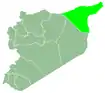
 Ras al-Ayn Location of Ras al-Ayn in Syria | |
| Coordinates: 36°51′01″N 40°04′14″E | |
| Country | |
| Governorate | al-Hasakah |
| District | Ras al-Ayn |
| Subdistrict | Ras al-Ayn |
| Control | |
| Elevation | 360 m (1,180 ft) |
| Population (2004)[1] | 29,347 |
| Time zone | UTC+2 (EET) |
| • Summer (DST) | UTC+3 (EEST) |
| Area code | +963 52 |
| Geocode | C4988 |
One of the oldest cities in Upper Mesopotamia, the area of Ras al-Ayn has been inhabited since at least the Neolithic age (c. 8,000 BC). Later known as the ancient Aramean city of Sikkan, the Roman city of Rhesaina, and the Byzantine city of Theodosiopolis, the town was destroyed and rebuilt several times, and in medieval times was the site of fierce battles between several Muslim dynasties. With the 1921 Treaty of Ankara, Ras al-Ayn became a divided city when its northern part, today's Ceylanpınar, was ceded to Turkey.
With a population of 29,347 (as of 2004),[1] it is the third largest city in al-Hasakah Governorate, and the administrative center of Ras al-Ayn District.
During the Syrian Civil War, the city became contested between Syrian opposition forces and People's Protection Units (YPG) from November 2012 until it was finally captured by the YPG in July 2013. It was later captured by the Turkish Armed Forces and the Syrian National Army during the 2019 Turkish offensive into north-eastern Syria.[3][4][5][6]
Etymology
The first mention of the town is in Akkadian Rēš ina[7] during the reign of the Assyrian king Adad-nirari II (911-891 BC).[7] The Arabic name Ras al-Ayn derives from the Akkadian and has the same meaning; "head of the spring",[7] or idiomatically, "hill of the spring", indicating a prominent mountain formation close to a well.
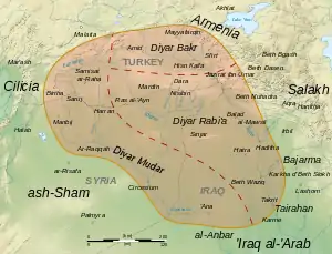
The ancient Greek geographer Ptolemy (d. 168) names the town Raisena.[8] The town, as part of the Roman Empire, was called Ressaina/Resaina.[9] Another name was Theodosiopolis, after emperor Theodosius I, who enlarged the town in 380.[8] The 11th century Arab geographer Muhammad al-Idrisi visited the town, mentioning its name as Ras al-'Ayn, and assigning it to Diyar Rabi'a (abode of the Arab tribe Rabi'a). He also described it as a big city with plenty of water, around 300 springs from which most of al-Khabur river starts.[10] In addition to Ras al-Ayn, medieval Arab Muslim sources refer to the town sometimes as Ain Werda.[8] Nineteenth-century English sources refer to the town as Ras Ain, Ain Verdeh (1819),[11] or Ras el Ain (1868).[8] The Kurdish name Serê Kaniyê also means "head of the spring" or "head of the fountain", referring to water source areas. This name is probably a modern literal translation of the ancient Semitic name.
_showing_Ras_al-Ain_in_Arabic_in_the_red_circle.jpg.webp)
Geography and climate
Ras al-Ayn is located in the Upper Khabur basin in the northern Syrian region of Jazira. The Khabur, largest tributary of the Euphrates, crosses the border from Turkey near the town of Tell Halaf, about 4 kilometres (2.5 mi) to the southwest of the city. The overground feeders, originating on the headwaters of the Karaca volcano in Şanlıurfa Province, usually do not carry water in the summer, even though Turkey brings in water from the Atatürk reservoir to irrigate the region of Ceylanpınar. While more than 80% of the Upper Khabur's water originates in Turkey, this mostly comes as underground flow.[12] So rather than the overground streams, it is the giant karstic springs of the Ras al-Ayn area that is considered the river's main perennial source.[13]
Ras al-Ayn springs
Ras al-Ayn has more than 100 natural springs. The most famous spring is Nab'a al-Kebreet, a hot spring with a very high mineral content, containing calcium, lithium, and radium.
Water supply
The Allouk water pumping station, which distributes water to the Hasakah Governorate, is close to Ras al-Ayn. Since the Turkish occupation began, the water supply has been interrupted several times.[14] Previously, the station supplied about 460,000 people in Al-Hasakah, Tell Tamer, and the Al-Hawl refugee camp, but not since the last interruption in March 2020, according to the United Nations High Commissioner for Refugees.[15]
History
%252C_Tell_Fakhariyah%252C_Pre-pottery_Neolithic_B%252C_9000-7000_BC%252C_gypsum_with_bitumen_and_stone_inlays_-_Oriental_Institute_Museum%252C_University_of_Chicago_-_DSC07633.JPG.webp)
%252C_Tell_Fakhariyah%252C_Pre-pottery_Neolithic_B%252C_9000-7000_BC%252C_gypsum_with_bitumen_and_stone_inlays_-_Oriental_Institute_Museum%252C_University_of_Chicago_-_DSC07636.JPG.webp)
Oriental Institute Museum, Chicago, USA.
Neolithic and ancient history
The area of Ras al-Ayn was inhabited at least since the Neolithic age (c. 8.000 BC). Today's Ras al-Ayn can be traced back to a settlement existing since c. 2000 BC, which in the early 1st millennium BC became the ancient city of Sikkan, part of the Aramaean kingdom of Bit Bahiani. The archaeological site is located on the southern edge of the mound Tell Fekheriye, around which today's Ras al-Ayn is built, just a few hundred meters south of the city center. During excavations in 1979, the famous Tell Fekheriye bilingual inscription was found. The nearby town of Tell Halaf is also a former site of an Aramean city.
Classical era
In later times, the town became known as "Rhesaina", "Ayn Warda", and "Theodosiopolis", the latter named after the Byzantine emperor Theodosius I who granted the settlement city rights. The latter name was also shared with the Armenian city of Karin (modern Erzurum) making it difficult to distinguish between them.[16]
The Sasanians destroyed the city twice in 578 and 580 before rebuilding it and constructing one of the three Sassanian academies in it (the other two being Gundishapur and Ctesiphon) in it.
Medieval history
The city fell to the Arabs in 640 who confiscated parts of the city which were abandoned by their inhabitants.[16] The Byzantines raided the city in 942 and took many prisoners. In 1129, Crusader Joscelin I managed to hold the city briefly, killing many of its Arab inhabitants.[16]
At its height the city had a West Syrian bishopric and many monasteries. The city also contained two mosques and an East Syrian church and numerous schools, baths, and gardens.[16]
Ras al-Ayn became contested between the Zengids, Ayyubids, and the Khwarazmians in the 12th and 13th centuries. It was sacked by Tamerlane at the end of the 14th century, ending its role as a major city in al-Jazira.[16]
Ottoman history
In the 19th century a colony of Muslim Chechen refugees fleeing the Russian conquest of the Caucasus were settled in the town by the Ottoman Empire.[8] The Ottomans also built barracks and a fort for a thousand soldiers to control and protect the refugees.[8]
During the Armenian Genocide, Ras al-Ayn was one of the major collecting points for deported Armenians. From 1915 on, 1.5 million Armenians were deported from all over Anatolia, many forced on death marches into the Syrian desert.[17] Approximately 80,000 Armenians, mostly women and children, were slaughtered in desert death camps near Ras al-Ayn.[18] As well as the Deir ez-Zor Camps further south, the Ras al-Ayn Camps became "synonymous with Armenian suffering."[19]
Modern history
After the fall of the Ottoman Empire and the 1921 Treaty of Ankara, Ras al-Ayn became a divided city when its northern neighborhoods, today's Ceylanpınar, were ceded to Turkey. Today, the two cities are separated by a fenced border strip and the Berlin–Baghdad Railway on the Turkish side. The only border crossing is located in the western outskirts of Ras al-Ayn. The town was first part of the French colonial empire's Mandate for Syria and the Lebanon and, from 1946, the independent state of Syria.
Civil War
During the Syrian Civil War, Ras al-Ayn was engulfed by the long Battle of Ras al-Ayn. In late November 2012, rebels of al-Nusra Front and the Free Syrian Army (FSA) attacked Syrian Army positions, expelling them from the town. During the following eight months, the Kurdish-majority People's Protection Units (YPG), present from the outset, gradually entrenched its position, and eventually formed an alliance with a non-jihadist FSA faction. On 21 July 2013, this alliance expelled the jihadists after a night of heavy fighting.
The town was part of Rojava for the following six years, until it was attacked and captured by the Turkish army and allied Syrian National Army during the October 2019 Turkish offensive into north-eastern Syria, in the Second Battle of Ras al-Ayn.[20][4] After 11 days of clashes and siege, the Syrian Democratic Forces retreated from Ras al-Ayn as part of a ceasefire agreement.[21] Ras al-Ayn is currently under the Turkish occupation of northern Syria.
Demographics
In 2004 the population was 29,347.[1] The town has been described as having an Arab majority,[22][23] in addition to Kurdish, Assyrian, Armenian and Syrian Turkmen minorities before the Turkish/SNA takeover in October 2019.[24][25][26][27][28][29] War crimes committed since the Turkish occupation began have since caused an exodus of Kurds, Christians, and other minorities from the town.[30][31][32][33] The Turkish government's resettling of mainly Arab Syrian refugees from other parts of Syria in Ras al-Ayn has further altered the town's demographics.[30][34]
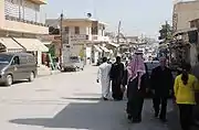 People in the city center
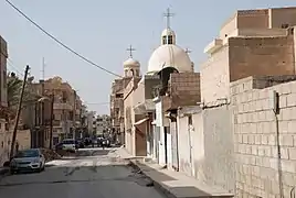 Orthodox church
 A view in October 2013. The city fell under SDF control during the Syrian Civil War
References
- "2004 Census Data for Nahiya Ras al-Ayn" (in Arabic). Syrian Central Bureau of Statistics. Also available in English: UN OCHA. "2004 Census Data". Humanitarian Data Exchange.
- Thomas A. Carlson et al., “Reshʿayna — ܪܝܫ ܥܝܢܐ ” in The Syriac Gazetteer last modified December 9, 2016, http://syriaca.org/place/172.
- "Sdf Recaptures Town Ras Al Ain Pro Turkish Forces in Northern Syria" Middle East Eye 15 October 2019 https://www.middleeasteye.net/news/sdf-recaptures-town-ras-al-ain-pro-turkish-forces-northern-syria
- "Turkey claims capture of key Syrian border town as offensive continues". NBC News. Retrieved 12 October 2019.
- http://www.syriahr.com/en/?p=144313
- https://tass.com/world/1084181
- Dominik Bonatz (1 April 2014). The Archaeology of Political Spaces: The Upper Mesopotamian Piedmont in the Second Millennium BCE. Walter de Gruyter. pp. 61–. ISBN 978-3-11-026640-5.
- Taylor, John George (1868). "Journal of a Tour in Armenia, Kurdistan and Upper Mesopotamia, with Notes of Researches in the Deyrsim Dagh, in 1866". In Royal Geographical Society (ed.). The Journal of the Royal Geographical Society. London. pp. 281–360, here: 346–350.
- J. B. Bury (18 July 2012). History of the Later Roman Empire. Courier Corporation. pp. 94–. ISBN 978-0-486-14338-5.
- Muhammad al-Idrisi (1154). نزهة المشتاق في اختراق الآفاق: Or, Tabula Rogeriana. عالم الكتب. pp. vol. 2, 661.
- Abraham Rees (1819). The Cyclopædia: Or, Universal Dictionary of Arts, Sciences, and Literature. Longman, Hurst, Rees, Orme & Brown. pp. 449–.
- Greg Shapland (1997). "The Tigris–Euphrates Basin". Rivers of Discord: International Water Disputes in the Middle East. London: Hurst & Company. pp. 103–143, here: 127. ISBN 1-85065-214-7.
- John F. Kolars; William A. Mitchell (1991). "A critical pressure point: The Ceylanpinar/Ras al-Ayn Area". The Euphrates River and the Southeast Anatolia Development Project. Carbondale and Edwardsville: Southern Illinois University Press. p. 222. ISBN 0-8093-1572-6.
- "Turkish-backed group's disruption of water puts 460,000 people at risk, UNICEF warns". www.kurdistan24.net. Retrieved 2020-03-24.
- "Interruption to key water station in the northeast of Syria puts 460,000 people at risk as efforts ramp up to prevent the spread of Coronavirus disease". www.unicef.org. Retrieved 2020-03-24.
- Gibb, Hamilton Alexander Rosskeen (1995). The Encyclopaedia of Islam: NED-SAM. Brill. pp. 433 f.
- https://www.theguardian.com/world/2015/apr/24/armenian-genocide-survivors-stories-my-dreams-cannot-mourn
- Sondhaus, Lawrence (2011). World War One: The Global Revolution. Cambridge: Cambridge University Press. p. 390. ISBN 978-0-521-51648-8.
- Jones, Adam (2006). Genocide: A Comprehensive Introduction (PDF). Routledge/Taylor & Francis. p. 110. ISBN 0-415-35385-8.
- "turkey-claims-capture-key-syrian-border-town" Al Jazeera https://www.aljazeera.com/news/2019/10/turkey-claims-capture-key-syrian-border-town-191012194413335.html
- "Kurdish forces depart border city of Ras al-Ayn as part of cease-fire with Turkey". Retrieved 27 November 2019.
- "Christians Killed on Syria's Front Lines". Christianity Today.
- "How will Syrian border towns react to Turkey's Operation Peace Spring?". Arab News.
- https://www.theaustralian.com.au/inquirer/kurds-americas-blood-sacrifice/news-story/f01f7802a41c7cc82c1c81e847b00c70
- https://www.rudaw.net/english/middleeast/syria/141120191
- https://www.trtworld.com/middle-east/why-didn-t-the-ypg-evacuate-civilians-before-the-turkish-operation-30511
- https://www.mcclatchydc.com/news/nation-world/world/article24740395.html
- https://english.aawsat.com//home/article/1887281/us-allied-kurdish-force-conduct-patrol-syrian-border
- http://www.xinhuanet.com/english/2019-10/20/c_138488354.htm
- https://www.independent.co.uk/news/world/middle-east/turkey-syria-safe-zone-ethnic-cleansing-death-toll-sna-a9225896.html
- http://www.asianews.it/news-en/Turks-and-jihadists-in-%E2%80%98soft%E2%80%99-ethnic-cleansing-of-Kurds-and-Christians-in-North-East-Syria-48418.html
- https://www.telegraph.co.uk/news/2019/11/17/kurds-watch-homes-burn-afar-picture-ethnic-cleansing-emerges/
- https://ahvalnews.com/syrian-safe-zone/ethnic-cleansing-already-taking-place-turkeys-syrian-safe-zone-independent
- https://ahvalnews.com/syrian-safe-zone/majority-refugees-forced-return-turkeys-syria-safe-zone-report
External links
![]() Media related to Ras al-Ayn, al-Hasakah Governorate at Wikimedia Commons
Media related to Ras al-Ayn, al-Hasakah Governorate at Wikimedia Commons