Rattanaburi District
Rattanaburi District (Thai: รัตนบุรี) is a district (amphoe) in the northeastern part of Surin Province, northeastern Thailand.
Rattanaburi
รัตนบุรี | |
|---|---|
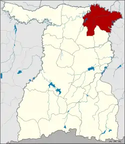 District location in Surin Province | |
| Coordinates: 15°19′13″N 103°51′25″E | |
| Country | Thailand |
| Province | Surin |
| Area | |
| • Total | 202.8 km2 (78.3 sq mi) |
| Population (2005) | |
| • Total | 94,060 |
| • Density | 463.8/km2 (1,201/sq mi) |
| Time zone | UTC+7 (ICT) |
| Postal code | 32130 |
| Geocode | 3207 |
History
Rattanaburi was a mueang under Mueang Surin, which was converted into a district in the Thesaphiban administrative reforms at the end of the 19th century.
Geography
Neighboring districts are (from the south clockwise): Non Narai, Sanom and Tha Tum of Surin Province; Suwannaphum and Phon Sai of Roi Et Province; and Rasi Salai, Bueng Bun, Pho Si Suwan and Mueang Chan of Sisaket Province.
Administration
The district is divided into 12 sub-districts (tambons), which are further subdivided into 163 villages (mubans). Rattanaburi is a township (thesaban tambon) which covers parts of tambons Rattanaburi and Phai. There are a further 12 tambon administrative organizations (TAO).
| No. | Name | Thai name | Villages | Pop. | |
|---|---|---|---|---|---|
| 1. | Rattanaburi | รัตนบุรี | 17 | 15,518 | |
| 2. | That | ธาตุ | 14 | 7,271 | |
| 3. | Kae | แก | 15 | 6,322 | |
| 4. | Don Raet | ดอนแรด | 16 | 9,760 | |
| 5. | Nong Bua Thong | หนองบัวทอง | 10 | 4,649 | |
| 6. | Nong Bua Ban | หนองบัวบาน | 15 | 10,999 | |
| 9. | Phai | ไผ่ | 14 | 9,573 | |
| 11. | Boet | เบิด | 17 | 7,702 | |
| 13. | Nam Khiao | น้ำเขียว | 13 | 5,704 | |
| 14. | Kut Kha Khim | กุดขาคีม | 11 | 5,912 | |
| 15. | Yang Sawang | ยางสว่าง | 11 | 4,508 | |
| 16. | Thap Yai | ทับใหญ่ | 10 | 6,142 |
Missing numbers are tambon which now form Non Narai District.