Rasi Salai District
Rasi Salai (Thai: ราษีไศล, pronounced [rāː.sǐː sā.lǎj]) is a district (amphoe) in the northern part of Sisaket Province, northeastern Thailand.
Rasi Salai
ราษีไศล | |
|---|---|
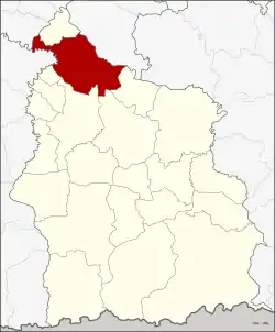 District location in Sisaket Province | |
| Coordinates: 15°20′25″N 104°9′14″E | |
| Country | Thailand |
| Province | Sisaket |
| Seat | Mueang Khong |
| Area | |
| • Total | 504.9 km2 (194.9 sq mi) |
| Population (2000) | |
| • Total | 82,333 |
| • Density | 163.1/km2 (422/sq mi) |
| Time zone | UTC+7 (ICT) |
| Postal code | 33160 |
| Geocode | 3309 |
Geography
Neighboring districts are (from the north clockwise): Phanom Phrai of Roi Et Province; Sila Lat of Sisaket Province; Maha Chana Chai and Kho Wang of Yasothon Province; Yang Chum Noi, Mueang Sisaket, Uthumphon Phisai, and Bueng Bun of Sisaket; and Rattanaburi of Surin Province.
The main river of the district is the Mun.
History
The district was renamed from Khong to Rasi Salai in 1939.[1]
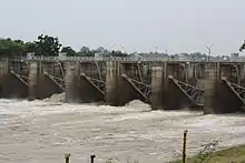
The Rasi Salai Dam was built here in 1994 and unofficially decommissioned in July 2000 following devastation of local farming villages as documented by Living River Siam.[2]
Administration
The district is divided into 13 sub-districts (tambons), which are further subdivided into 190 villages (mubans). Mueang Khong is a township (thesaban tambon) and covers parts of tambon Mueang Khong. There are a further 13 tambon administrative organizations (TAO).
| No. | Name | Thai name | Villages | Pop. | |
|---|---|---|---|---|---|
| 1. | Mueang Khong | เมืองคง | 15 | 7,523 | |
| 2. | Mueang Khaen | เมืองแคน | 14 | 6,600 | |
| 3. | Nong Khae | หนองแค | 17 | 7,803 | |
| 6. | Chik Sang Thong | จิกสังข์ทอง | 10 | 3,999 | |
| 7. | Dan | ด่าน | 13 | 5,206 | |
| 8. | Du | ดู่ | 14 | 7,362 | |
| 9. | Nong Ueng | หนองอึ่ง | 17 | 8,594 | |
| 10. | Bua Hung | บัวหุ่ง | 18 | 6,822 | |
| 11. | Phai | ไผ่ | 12 | 5,334 | |
| 12. | Som Poi | ส้มป่อย | 17 | 7,188 | |
| 13. | Nong Mi | หนองหมี | 18 | 5,937 | |
| 14. | Wan Kham | หว้านคำ | 13 | 5,142 | |
| 15. | Sang Pi | สร้างปี่ | 12 | 4,823 |
Missing numbers are tambons which now form Sila Lat District.
References
- พระราชกฤษฎีกาเปลี่ยนนามอำเภอ กิ่งอำเภอ และตำบลบางแห่ง พุทธศักราช ๒๔๘๒ (PDF). Royal Gazette (in Thai). 56 (0 ก): 354–364. April 17, 1939.
- "Executive Summary of Rasi Salai Thai Baan Research" (PDF). Living Rivers Siam. Retrieved 29 April 2018.
External links
- amphoe.com (Thai)
Sisaket (capital) | ||
| Districts (amphoe) |  | |
| Related topics | ||
| Neighboring areas |
| |