Red route
The term red route has been separately adopted for two entirely different highway purposes within the United Kingdom.
Congestion reduction
In London, Leeds[1] and the county of West Midlands[2] in the United Kingdom, red routes are major roads on which vehicles are not allowed to stop, first introduced in north and east London in 1991.[3] The prohibition extends to stopping for loading or unloading, and to boarding or alighting from a vehicle (except for licensed taxis and the holders of blue badges).[4] Red routes are mainly used on major bus and commuting routes.[5]
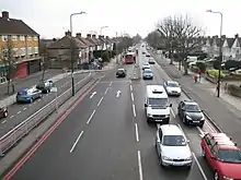
Red routes are marked by red lines on the sides of the road. Double red lines mean that the rules and regulations apply at all times and on all days. Single red lines means that the prohibition applies during times displayed on nearby signs or at the entry to the zone.[4] Red route clearways are signed but there are no lines on the road. Stopping is only permitted in lay-bys (red lines are only marked at junctions).[6]
The 390 miles of red routes in London are policed by "Red Route Patrols" and managed by London Streets, an arm of Transport for London.[7]
A similar scheme operates in Edinburgh; here, however, the routes affected (where marked by the use of green road-surfacing rather than red lines - usually on outer bus lanes on major bus routes) are known as "Greenways". Away from bus routes, conventional red lines are used.
A number of hospitals in the United Kingdom have mimicked the red road lines, in and around ambulance dispatch and Accident and Emergency areas. These road markings are to allow ambulances and other emergency vehicles uninhibited access in and out of such areas; whilst these road markings are often respected by road users there is very little (if any) enforcement.
Accident reduction
In Somerset, the local road safety partnership has designated some of the A roads within the county as Red Routes, but in this case the term is used to indicate routes that have a higher than average accident rate.[8][9][10]
The term is similarly used to denote dangerous routes in Northamptonshire.[11][12][13] It is not clear that the scheme will be maintained following the closure of the Road Safety Partnership whose initiative it was.[14]
Lincolnshire has a scheme similar to the Northamptonshire one.[15][16]
The county of Cheshire, and therefore the town of Warrington also use the idea of Red Routes to designate roads with historically high accident rates.[17][18]
The former[19] Suffolk speed camera organisation chose the expression Red Route to denote routes where high levels of accidents justify the frequency use of mobile speed cameras.[20]
Leicestershire County Council has chosen not to implement a Red Route scheme, believing it can be misleading and arbitrary. It believes in identifying or solving individual danger spots instead.[21]
London
While one aim of the 1991 Red Routes scheme in London was to reduce congestion, the scheme has a political role in London's transport network.
History
The Red Routes scheme was developed by the Department for Transport following the abolition of the Greater London Council in 1986 to address concerns that there was no London-wide road transport policymaking body.[3]
A Traffic Director for London was appointed by the Department for Transport in 1991 to "streamline the flow of traffic in London" and oversee a London-wide strategy for road transport.[22]
The director was responsible for creating a Network Plan, deciding on the priorities for road travel in London and how best to manage traffic flows. Roads in the Network Plan became the responsibility of the Traffic Director rather than localised London boroughs.[3]
In 1998, the Traffic Director identified nine priorities for the Red Routes scheme:
- to facilitate the movement of people and goods in London—reliably and safely, and with minimum overall environmental impact;
- to encourage walking;
- to improve conditions for cyclists and contribute to the National Cycling Strategy;
- to provide better conditions for people with disabilities;
- to provide priority for buses so as to achieve their efficient movement;
- to improve the local environment and reduce the impact of congestion;
- to contribute to London's targets for reduced traffic accidents and road vehicle emissions;
- to support reduced car commuting, especially into or across inner London;
- to assist measures to reduce traffic on local roads by providing the first choice for non-local traffic, consistent with achieving the other aims for Red Routes.[3]
Between 1997 and 2000, transport policy in the United Kingdom became a devolved matter under Tony Blair, with the Senedd in Wales and the Scottish Parliament assuming control over nationwide and regional transport strategy in their respective nations. When London was granted a devolved assembly and authority, which came into effect in 2000, regional transport strategy became the responsibility of the Mayor of London.[23]
The Greater London Authority (GLA) Act 1999, which established the devolved administration in London, gave the Mayor of London a General Transport Duty to "develop and implement policies for the promotion and encouragement of safe, integrated, efficient and economic transport facilities and services to, from and within Greater London". Transport for London (TfL) became the highway authority for all roads under GLA control.[24]
The Greater London Authority Act 1999 passed the management of motorways wholly within London and trunk roads over to the GLA. This caused several roads to be renumbered in London, including the A102(M) Blackwall Tunnel (to A102), the A40(M) Westway (to A40) and the M41 West Cross Route (to A3220).[24]
Routes
Red Routes are managed and controlled by London Streets, which is an arm of Transport for London (TfL).
| Route | Start of TfL Control | End of TfL Control | Notes |
|---|---|---|---|
| A1 | Angel, Islington | Borehamwood | |
| A10 | London Bridge | M25 Junction 25 | Including Cycleway 1 |
| A11 | Aldgate | Bow Interchange | Including Cycleway 2 |
| A12 | Blackwall Tunnel | M25 Junction 28 | |
| A13 * | Aldgate | Purfleet | Including Cycleway 3
|
| A100 | Tower Bridge | Bricklayers Arms | Including Tower Bridge
|
| A101 | Limehouse | Bermondsey | Rotherhithe Tunnel |
| A102 | Lower Clapton | Hackney Wick | |
| A102 | Blackwall Tunnel | Blackheath | Formerly |
| A107 | Stamford Hill | Lower Clapton | |
| A127 | Gallows Corner | M25 Junction 29 | |
| A1020 | Beckton | Woolwich Ferry | |
| A1023 | Tower Bridge | Limehouse Link | |
| A1202 | Aldgate | Old Street | Part of the London Inner Ring Road |
| A1205 | Bow | Poplar | |
| A1261 * | Limehouse | Leamouth | *Under private-sector contract |
| A1400 | M11 Junction 4 | Gants Hill | |
| A2 | Borough | Bexley | |
| A20 | New Cross | Ruxley | |
| A21 | Lewisham | M25 Junction 4 | |
| A22 | Purley | Whyteleafe | |
| A23 | Kennington | Chipstead | |
| A24 | Clapham Common | Nonsuch Park, Cheam | Including Cycleway 7 |
| A200 | London Bridge | Bermondsey | Including Cycleway 4 |
| A201 | King's Cross | Bricklayers Arms | Including Cycleway 6 |
| A202 | Victoria | New Cross | Including Cycleway 5 and Vauxhall Bridge
|
| A203 | Vauxhall | Brixton | |
| A205 | M4 Chiswick | Woolwich Ferry | South Circular Road |
| A210 | Lee | Eltham Green | |
| A214 | Wandsworth | Streatham | |
| A217 | Rosehill | Belmont | |
| A232 | Nonsuch Park, Cheam | Locksbottom | |
| A240 | Kingston Bypass | Worcester Park Road | |
| A243 | Kingston Bypass | Ashtead Common | |
| A2213 | Kidbrooke | Lee | |
| A3 | London Bridge | Ditton Hill | Except Elephant & Castle to A2
|
| A30 | Cranford | Staines | |
| A302 | Parliament Square | Elephant & Castle | Except Waterloo to the Imperial War Museum
|
| A306 | Barnes | Roehampton | |
| A312 | Northolt | Hanworth | |
| A316 | Chiswick | Sunbury-on-Thames | |
| A3036 | Vauxhall | Westminster Bridge | |
| A3200 | Westminster Bridge | London Bridge | |
| A3203 | Millbank | Lambeth | Lambeth Bridge only |
| A3204 | Vauxhall | Elephant & Castle | Part of the London Inner Ring Road |
| A3205 | Vauxhall | Wandsworth | Including Cycleway 8 |
| A3211 | Westminster | Tower Bridge | Including Cycleway 3 |
| A3212 | Westminster | Battersea Bridge | Including Cycleway 8 |
| A3220 | The Westway | Clapham Common | Including Battersea Bridge
|
| A4 | Hyde Park Corner | Longford | |
| A40 | The Westway | Uxbridge | Part formerly |
| A41 | Baker Street | M1 Junction 4 | |
| A400 | Euston | Camden Town | |
| A406 | M4 Chiswick | Beckton | North Circular Road |
| A4180 | Northolt | Ruislip | |
| A4200 | Camden Town | Mornington Crescent | |
| A4202 | Marble Arch | Hyde Park Corner | Part of the London Inner Ring Road |
| A5 | Hyde Park Corner | Warwick Avenue | Part of the London Inner Ring Road |
| A501 | The Westway | Old Street | Part of the London Inner Ring Road |
| A503 | Camden Town | Seven Sisters | |
| A5205 | Warwick Avenue | Regent's Park |
References
- Johnson, Kristian (20 February 2019). "Double red lines introduced at Leeds Bradford Airport in crackdown on terror". Leeds Live.
- "Red Routes". Birmingham City Council. Retrieved 1 April 2010.
- The Committee Office, House of Commons (22 February 1999). "Memorandum by The Traffic Director for London (IT 160) - Environment, Transport and Regional Affairs - Minutes of Evidence". Publications.parliament.uk. Archived from the original on 27 October 2016. Retrieved 14 July 2017.
- "Road markings" (PDF). direct.gov. Retrieved 1 April 2010.
- "Red Routes West Midlands". West Midlands Local Transport Plan. 2010. Archived from the original on 28 July 2013. Retrieved 6 August 2013.
- "Transport for London Understanding road signs". Transport for London. Retrieved 1 April 2010.
- "Surface Transport". Transport for London. Retrieved 11 August 2012.
- "A37 Red Route leaflet" (PDF). Somerset Road Safety Partnership. Retrieved 13 September 2010.
- "Safety measure for busy routes". This is Somerset (Western Gazette etc.). 30 May 2009. Retrieved 5 August 2013.
- Hill, Phil (9 March 2009). "A361 red route exhibition". Somerset County Gazette. Retrieved 5 August 2013.
- "Red routes total rises". Northamptonshire Telegraph. 28 April 2010. Retrieved 5 August 2013.
- "Accident blackspots on red route revealed". Northampton Chronicle and Echo. 27 April 2006. Retrieved 5 August 2013.
- "Danger road' A6 now a Red Route". Northamptonshire Telegraph. 14 June 2013. Retrieved 6 August 2013.
- "Northamptonshire's road safety partnership disbands". BBC News. 1 April 2011. Retrieved 6 August 2013.
- "RED ROUTES MARK 'DANGER' ROADS". Lincolnshire Free Press. 28 January 2003. Retrieved 6 August 2013.
- "Road safety group claims Red Route signs are 'effective' as casualty figures halve". Lincolnshire Echo. 17 February 2011. Retrieved 5 August 2013.
- Davies, Nicola Davies (14 February 2008). "Eleven roads have 'high risk of death'". This is Cheshire. Retrieved 6 August 2013.
- "Red Routes". Warrington Borough Council. Archived from the original on 5 June 2013. Retrieved 6 August 2013.
- "Suffolk safecam is now closed". Suffolk County Council. Archived from the original on 14 July 2013. Retrieved 6 August 2013.
- Focus on Safety (leaflet) (PDF). Suffolk Roadsafe Board. p. 2.
- "Accident reduction and red routes" (PDF). Leicestershire County Council. 17 April 2008. Retrieved 6 August 2013.
- Records of the Traffic Director for London. Traffic Director for London. 1991–1999.CS1 maint: others (link) CS1 maint: date format (link)
- Butcher, Louise (12 August 2020). "Transport in Scotland, Wales & Northern Ireland". Cite journal requires
|journal=(help) - "Greater London Authority Act (1999)".
- Transport for London (TfL) (2002). "Transport for London Street Management" (PDF). Transport for London. Archived (PDF) from the original on 29 November 2020. Retrieved 8 December 2020.
- Transport for London (TfL) (2015). "Pan-London Red Routes" (PDF). Transport for London. Archived (PDF) from the original on 12 November 2020. Retrieved 8 December 2020.
External links
- London red route rules
- West Midlands red routes
- "Red Routes". Lincolnshire Road Safety Partnership. Retrieved 5 August 2013.
