Leamouth
Leamouth is a mixed-use development[1] and historically a wharf in the Port of London in Blackwall.[2] It lies on the west side of the confluence of the Bow Creek stretch of the Lea, and the River Thames.
The neighbourhood consists of two small peninsulas, separated from the rest of Poplar by both the river and the remaining part of the East India Docks and became more seen as part of Canning Town. The northern peninsula lies in a hairpin meander and is named Goodluck Hope after one of the adjacent reaches of the Lea, while the other is known as Orchard Place.
The area was long referred to locally as Bog Island, due to its inaccessibility and propensity to flood; however the building of the Thames Barrier and the artificial raising of the more vulnerable riverside land, means the nickname refers to a now much reduced threat.
History
This area of Poplar was traditionally the easternmost part of Middlesex. The area has never had its own Anglican church so for services such as road maintenance organised by a vestry and poor relief it relied upon its ecclesiastical parish (of All Saints) Poplar.[3] Indeed, the whole Isle of Dogs was until the late 20th century referred to as being Poplar or the Poplar District.[4]
Orchard Place was the name of its manor house on the spit; this had become an eponymous public house from 1800–60. When the docks were constructed, the area became isolated, with the only access via the dock road, from Poplar. Residents were engaged at the glass works, the iron and engineering works, or the Samuda Brothers, Orchard House Yard and Thames Iron Works ship yards. When the Thames Plate Glass Works closed in 1874, many of the hands – who had migrated to the area from Tyneside and St Helens in the 1840s – followed the glassworks to New Albany, Indiana. To house the workers, there were about 100 small two-storied cottages – built from the 1820s and condemned in 1935.[5] There was the Bow Creek school (founded in 1865), but few shops, and The Crown, a public house, opened about 1840.[6]
By the late 19th century the vicinity of Orchard Place had become a deprived area and was inhabited by rough and very poor people who were living in overcrowded conditions. In the late 1930s, all homes and shops were demolished in a slum clearing project with residents were moved out of the area.[7]
The London City Island is a major redevelopment project by architects Glenn Howells that will provide 1,706 homes, stores, shops, restaurants, cafés, and arts facilities including the English National Ballet and London Film School.[8]
Geography
One street, Orchard Place, runs through the former industrial area and the Lower Lea Crossing crosses the narrow strip of land between the two tongues. The northern part was principally occupied by Pura Foods Ltd vegetable oil refinery – on the site of the former Thames Plate Glass Works; and the south by engineering works, shipyards (Thames Iron Works and Orchard House Yard) and Trinity Buoy Wharf which contains London's only lighthouse. There are also live-work units, many in the form of the Container Cities. The "Jubilee" pedestrian bridge across the Lea links the area to the east bank of the Lea, and Canning Town station.
Industry

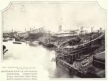
Known as Leamouth Wharf, one of it most significant industries was the shipyard and iron works site called Thames Ironworks and Shipbuilding Company, which was based at the mouth of Bow Creek right at its confluence with the River Thames.[9]
Little industry remains in Leamouth today. One of the last survivors, the Pura Foods edible oil works, in a loop of Bow Creek at Orchard Place, closed down in 2006. This site had once been occupied by the Thames Plate Glass Works. For many years the sugar firm Fowler's, a significant maker of treacle, was in Leamouth.
Access
The Leamouth Peninsula has historically had poor transport links compared to the rest of Poplar, today it is connected to it by a main road splitting its halves: the A1020 Lower Lea Crossing which is a local by-pass of the A13.
Leamouth has been served by the London Buses network for the first time by the D3 to Bethnal Green which starts and ends on Orchard Place since 2017.[10] The N550 between Canning Town station and Blackwall was rerouted via Leamouth to provide night links whenever access to Canning Town station is restricted;[11] implemented in September 2018.[12]
References
- https://www.british-history.ac.uk/survey-london/vols43-4/pp646-655
- "Pg24, citing study into West Hams community ties" (PDF). Leeds Metropolitan University. Archived from the original (PDF) on 17 January 2005.
- Church of England Website Poplar ecclesiastical parish map
- A Survey of London 1994, Hermione Hobhouse (Gen. Ed.)
- The cottages typically consisted of four rooms and a wash-house.
- Charles Lammin Memories of Orchard House (East London History Society, 1961)
- https://www.hidden-london.com/gazetteer/leamouth/amp/
- "GHA Project | London City Island". Glenn Howells Architects. Retrieved 23 May 2019.
- Survey of London: volumes 43 and 44, Leamouth Wharf edited by Hermione Hobhouse, 1994
- Bus Services Changes 19 August to 8 October inclusive Transport for London
- https://consultations.tfl.gov.uk/buses/routes-d3-n550/
- https://tfl.gov.uk/modes/buses/permanent-bus-changes#on-this-page-3
.jpg.webp)

