Tamborine Mountain
Tamborine Mountain is a 28 km2 (11 sq mi) plateau (8 km long by 4 km wide) and locality in the Scenic Rim Region of South East Queensland, Australia.[2][3] The name is of Aboriginal origin and is frequently misspelt as Tambourine (with a "u") but neither the name nor the place has any connection to the musical instrument. It is considered part of the Gold Coast hinterland and has a strong tourist industry.
| Tamborine Mountain (Jambreen) | |
|---|---|
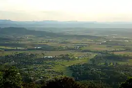 Tamborine Mountain landscape | |
| Highest point | |
| Elevation | 525 m (1,722 ft) |
| Geography | |
| Location | Queensland, Australia |
| Parent range | Great Dividing Range |
| Geology | |
| Age of rock | Aquitanian |
| Mountain type | Shield volcano |
| Tamborine Mountain Queensland | |||||||||||||||
|---|---|---|---|---|---|---|---|---|---|---|---|---|---|---|---|
 Tamborine Mountain | |||||||||||||||
| Coordinates | 27°58′10″S 153°11′57″E | ||||||||||||||
| Population | 7,506 (2016 census)[1] | ||||||||||||||
| Postcode(s) | 4272 | ||||||||||||||
| LGA(s) | Scenic Rim Region | ||||||||||||||
| State electorate(s) | Scenic Rim | ||||||||||||||
| Federal Division(s) | Wright | ||||||||||||||
| |||||||||||||||
History
Tamborine Mountain was inhabited by Aboriginal People for tens of thousands of years and, at the time of early European settlement, lay in the territory of the Wangerriburras. The origin of the name Tamborine comes from the Anglicised version of the Aboriginal word Jambreen from the Yugambeh language.[4] The spelling also appears on early records as Tchambreem and even Goombireen,[4] which means 'wild lime' and refers to the finger lime trees growing on the mountain.
Prior to settlement, the mountain was covered with a diverse range of forest types.[4] Unlike the lower land surrounding the mountain, the thick scrub on the mountain was seen as a barrier to settlement so the mountain was not opened for selection until 1875.[5] However, the selectors were living in the surrounding area and being within 15 miles (24 km) of their selections were exempt from the requirements to live on their selections. Most did not develop the land and sold it once they were granted freehold.[6] In 1878 the first selectors settled on the mountain blocks: John O'Callaghan (deputising for William Walsh) and his nephew, E.H. O'Callaghan.[7] By 1886 most of the mountain had been selected but electoral rolls and church records suggest very few people were living on the mountain.[6]
On 30 January 1893 auctioneers Arthur Martin & Co offered 128 blocks of land, mostly 2-acre (0.81 ha) lots, in the St Bernard Estate, bounded by Alpine Terrace to the north and to the south by Power Parade, St Bernard Street and Siganto Street.[8] The lots were described as suitable for gentlemen's residences with "scenery unsurpassed in Australia" and for the shooter "turkeys, pigeons, wallabies and kangaroos abound".[9]
Much clearing for agriculture took place, though efforts were made to protect the natural values of the area, with Witches Falls National Park (now part of the Tamborine National Park) being declared in 1908, the first in Queensland.[4] The Tamborine National Park is made up of 12 separate sections of land, mainly remnant rainforest, on the plateau and surrounding foothills. A tourist road to the mountain was opened in 1924.[7]
On 30 May 1926 a United Protestant Church was opened in Eagle Heights Road on land donated by Mrs SA Jenyns. It was built by Mr V Anderson. It was available for use by all Protestant denominations but legally owned by the Presbyterian Church. The church continued to be used in that way until the late 1960s. It was purchased by May and Henry Bishopp in 1982 and donated to the Tamborine Mountain Historical Society, who relocated the church to their Tamborine Mountain Heritage Centre at 53 Wongawallan Road (27.9208°S 153.2047°E).[10]
In 1927 a branch of the Queensland Country Women's Association was established.[11]
In 1930 land was purchased at 2–4 Geissmann Street on the corner with Main Street (27.9238°S 153.1853°E) as a site for a Presbyterian church. A stump capping ceremony was held on 31 January 1931. The Mount Tamborine Presbyterian Church church officially opened on Saturday on 20 June 1931. The total cost of the land and the building was £450.[12] The manse was located at 29 Griffith Street.[13] By 1972 the growing congregation was too large for the church and so it was decided to purchase a 1-acre (0.40 ha) nearby site at 34–36 Main Street (27.9242°S 153.1854°E). The United Protestant Church was closed in March 1972 and sold for $10,000 to Mr E Tannock to fund the new church with the bell and its tower being removed to incorporate into the new church. The manse in Griffith Street was also sold to raise funds. The new church was consecrated on 3 May 1975 by Reverend Colin Kay.[14] A hall was erected at the rear of the new church in 1980.[15] The church on Geissmann Street was sold to fund a new manse.[16] The congregation continued to grow and the church building was extended to double its size and add other amenities. The extended church was officially opened on 14 November 2010.[17]
On 25 September 1990, 11 people were killed and 38 injured when a bus overturned and rolled down a slope on Henri Robert Drive. Most were senior citizens from a social club in Newcastle, New South Wales.[18][19][20] A coronial inquest did not support the laying of criminal charges in relation to the incident.[20]
In the 2016 census, Tamborine Mountain had a population of 7,506 people.[1]
Heritage listings
Tamborine Mountain has a number of heritage-listed sites, including:
Environment
Geology
The geological origin of the plateau is a lava flow from the Mount Warning volcanic eruption 22 million years ago. Tamborine Mountain rises at the start of the north-east section of the Scenic Rim, the name given to a group of mountains in South East Queensland.
Important Bird Area
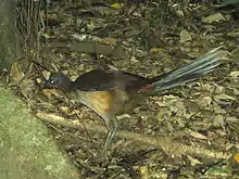
Parts of the plateau and surrounding foothills encompassing the wet subtropical rainforest habitats below the largely cleared plateau summit, and above the surrounding eucalypt forests, have been identified as a 38 km2 (15 sq mi) Important Bird Area (IBA) by BirdLife International. It includes the southern fragments of the Tamborine National Park. The IBA supports an isolated northern population of Albert's lyrebirds, as well as pale-yellow robins, green catbirds, regent bowerbirds and Australian logrunners.[23] Additional significant birds recorded from the site are glossy black cockatoos, sooty owls, marbled frogmouths and noisy pittas. Other animals present in the IBA include platypuses, short-beaked echidnas and Richmond birdwings.[24]
Geography
_Dec_2013.jpg.webp)
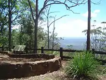
Human settlement on the plateau is centred on three village communities: North Tamborine, Eagle Heights and Mount Tamborine, with a total population of about 5,100.[25] The plateau is classified as a rural area, with zoning restrictions that prohibit property from being subdivided. There is no reticulated water supply or sewerage system, and residents are dependent on rainwater, bores and septic systems. Many residents commute to work on the Gold Coast or in Brisbane.
Climate
The climate is a subtropical highland climate (Cfb, according to the Köppen climate classification), with the annual rainfall of about 1,550 mm[25] falling mainly between December and March. Temperatures vary between maxima of 17 °C in winter and 25 °C in summer, and are usually 5 °C to 7 °C degrees cooler than the surrounding lowlands. Winters are usually dry and sunny, with cool maximum temperatures; however, the temperature rarely drops below freezing due to the thick forest cover. With its fertile red volcanic soil and high rainfall, the plateau produces rich crops of avocados, kiwifruit, passionfruit, rhubarb, apples and mangoes. With its relatively cool climate and spectacular scenery, as well as its proximity to Brisbane, the Gold Coast and Surfers Paradise, it is a major tourist destination. The Mountain receives an average of 102.9 clear days, annually.[26]
| Climate data for Mt Tamborine | |||||||||||||
|---|---|---|---|---|---|---|---|---|---|---|---|---|---|
| Month | Jan | Feb | Mar | Apr | May | Jun | Jul | Aug | Sep | Oct | Nov | Dec | Year |
| Record high °C (°F) | 35.7 (96.3) |
35.3 (95.5) |
34.9 (94.8) |
31.4 (88.5) |
27.4 (81.3) |
26.6 (79.9) |
25.4 (77.7) |
24.9 (76.8) |
29.6 (85.3) |
35.8 (96.4) |
37.8 (100.0) |
37.8 (100.0) |
37.8 (100.0) |
| Average high °C (°F) | 25.7 (78.3) |
25.3 (77.5) |
24.4 (75.9) |
22.6 (72.7) |
19.8 (67.6) |
17.7 (63.9) |
17.1 (62.8) |
18.3 (64.9) |
20.3 (68.5) |
22.6 (72.7) |
24.6 (76.3) |
25.9 (78.6) |
22.0 (71.6) |
| Average low °C (°F) | 17.1 (62.8) |
17.3 (63.1) |
16.4 (61.5) |
14.0 (57.2) |
11.2 (52.2) |
9.1 (48.4) |
8.0 (46.4) |
8.6 (47.5) |
10.4 (50.7) |
12.8 (55.0) |
14.8 (58.6) |
16.3 (61.3) |
13.0 (55.4) |
| Record low °C (°F) | 11.7 (53.1) |
10.3 (50.5) |
6.9 (44.4) |
7.6 (45.7) |
3.8 (38.8) |
−0.6 (30.9) |
1.4 (34.5) |
−1.1 (30.0) |
−0.3 (31.5) |
4.7 (40.5) |
8.3 (46.9) |
9.6 (49.3) |
−1.1 (30.0) |
| Average rainfall mm (inches) | 224.6 (8.84) |
223.6 (8.80) |
190.1 (7.48) |
131.2 (5.17) |
122.5 (4.82) |
98.8 (3.89) |
82.2 (3.24) |
55.8 (2.20) |
57.1 (2.25) |
91.1 (3.59) |
120.9 (4.76) |
165.2 (6.50) |
1,563.1 (61.54) |
| Average rainy days (≥ 0.2mm) | 14.8 | 15.0 | 15.9 | 12.2 | 10.9 | 9.0 | 8.5 | 7.5 | 8.3 | 10.0 | 12.0 | 13.1 | 137.2 |
| Source: Bureau of Meteorology[26] | |||||||||||||
Tourism
Tamborine Mountain attracts many tourists to "Gallery Walk" along Long Road, a street devoted to art galleries, cafes and souvenir shops.[25] Other tourism-heavy areas include Main Street, two one-way roads with cafes, library, fuel, hardware stores, newsagent, the Zamia Theatre, various other shops, and the Tamborine Showground Markets, held every second Sunday of the month. A new major shopping precinct contains more of the above, and a SupaIGA supermarket.
The Glow-Worm Caves are a man-made attraction which opened to visitors in March 2006.[27] They are located in one of the many wineries on the mountain. There are several fine dining locations.
Walking tracks
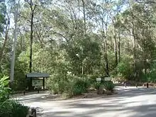
Tamborine Mountain is well known for walking tracks winding through rainforest regions and occasionally past cliffs or waterfalls. The most well-known ones are the Curtis Falls rainforest track and the Knoll. The Palm Grove walk is a 30-minute downhill trek to a massive fallen fig tree (blown down by storms in 2013) through a vast skyline filled with 30-metre (98 ft) tall palms. The track passes mountain streams, a waterfall and wildlife. The Botanic Gardens are found in Eagle Heights.
Schools
- Tamborine Mountain State High School (Secondary years 7–12)
- Tamborine Mountain College (Primary in 2015 – preps–6, secondary years 7–12)
- Tamborine Mountain State School (primary – year 1 – 7)
- St Bernards State School (primary – year 1 – 7)
Amenities
The Scenic Rim Regional Council operates a public library on the corner of Main Street and Yuulong Road.[28]
See also
References
- Australian Bureau of Statistics (27 June 2017). "Tamborine Mountain (SSC)". 2016 Census QuickStats. Retrieved 7 August 2020.

- "Tamborine Mountain – plateau (entry 33236)". Queensland Place Names. Queensland Government. Retrieved 31 January 2016.
- "Tamborine Mountain – locality (entry 48962)". Queensland Place Names. Queensland Government. Retrieved 31 January 2016.
- "Tamborine National Park: Nature, culture and history". Department of Environment and Resource Management. 2 December 2010. Archived from the original on 13 April 2010. Retrieved 22 June 2011.
- "Logan and Albert". The Queenslander. X (5). Queensland, Australia. 18 September 1875. p. 6. Retrieved 27 July 2020 – via National Library of Australia.
- 1931–2011 Tamborine Mountain Presbyterian Church, page 1
- Environmental Protection Agency (Queensland) (2000). Heritage Trails of the Great South East. State of Queensland. p. 14. ISBN 0-7345-1008-X.
- "St Bernard Estate, Tamborine Mountain". hdl:10462/deriv/18534. Cite journal requires
|journal=(help) - "Classified Advertising". The Brisbane Courier. XLIX (10, 934). Queensland, Australia. 30 January 1893. p. 8. Retrieved 29 October 2019 – via National Library of Australia.
- 1931–2011 Tamborine Mountain Presbyterian Church, pp 2, 5, 9
- 1931–2011 Tamborine Mountain Presbyterian Church, page 7
- 1931–2011 Tamborine Mountain Presbyterian Church, pp 8
- 1931–2011 Tamborine Mountain Presbyterian Church, pp 26
- 1931–2011 Tamborine Mountain Presbyterian Church, pp 53, 55, 84–85
- 1931–2011 Tamborine Mountain Presbyterian Church, pp 76
- 1931–2011 Tamborine Mountain Presbyterian Church, pp 84
- 1931–2011 Tamborine Mountain Presbyterian Church, pp 78–79
- "11 pensioners die, 42 hurt in bus crash". The Canberra Times. 26 September 1990.
- "Study of injury mechanisms of the Mt Tamborine coach crash, September 25, 1990: TRID record". Transportation Research Board. Retrieved 30 August 2020.
- "Charges should not be laid over crash: coroner". The Canberra Times. 24 July 1991.
- "Tamborine Mountain Road/Geissmann Drive (entry 602365)". Queensland Heritage Register. Queensland Heritage Council. Retrieved 12 July 2013.
- "Local Heritage Register" (PDF). Scenic Rim Regional Council. Archived from the original (PDF) on 24 September 2015. Retrieved 9 February 2015.
- "IBA: Tamborine Mountain". Birdata. Birds Australia. Archived from the original on 6 July 2011. Retrieved 29 October 2011.
- BirdLife International. (2011). Important Bird Areas factsheet: Tamborine Mountain. Downloaded from http://www.birdlife.org Archived 10 July 2007 at WebCite on 30 October 2011.
- "Tamborine Mountain". Scenic Rim Regional Council. Archived from the original on 6 October 2011. Retrieved 27 June 2011.
- "MT TAMBORINE FERN ST". Climate statistics for Australian locations. Bureau of Meteorology. December 2015. Retrieved 1 December 2015.
- Glow Worm Caves – Cedar Creek Estate Winery & Vineyard, Mount Tamborine Archived 19 July 2011 at the Wayback Machine. Retrieved on 20 July 2011.
- "Locations and Membership". Scenic Rim Regional Council. Archived from the original on 30 January 2018. Retrieved 31 January 2018.
Sources
- "1931–2011 Tamborine Mountain Presbyterian Church" (PDF). Tamborine Mountain Presbyterian Church. Archived (PDF) from the original on 5 March 2020. Retrieved 27 July 2020.
External links
| Wikimedia Commons has media related to Tamborine Mountain, Queensland. |
| Wikivoyage has a travel guide for Tamborine Mountain. |
- "Tamborine Mountain". Queensland Places. Centre for the Government of Queensland, University of Queensland.
- Discover Tamborine Mountain
- Tamborine Mountain Natural History Association