Rochester, Indiana
Rochester is a city in, and the county seat of, Fulton County, Indiana, United States.[9] The population was 6,218 at the 2010 census.
City of Rochester, Indiana | |
|---|---|
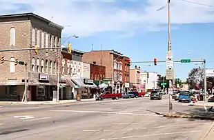 Rochester business district | |
| Motto(s): "The City of Friendship and Pride"[1] | |
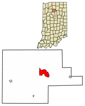 Location of Rochester in Fulton County, Indiana. | |
| Coordinates: 41°3′43″N 86°12′24″W | |
| Country | United States |
| State | Indiana |
| County | Fulton |
| Settled | 1835 [2] |
| Incorporated Town | June 11, 1853 [2] |
| Incorporated City | October 11, 1909 [2] |
| Government | |
| • Mayor | Ted Denton[3] (R) |
| Area | |
| • Total | 5.68 sq mi (14.71 km2) |
| • Land | 4.57 sq mi (11.84 km2) |
| • Water | 1.11 sq mi (2.87 km2) 19.14% |
| Elevation | 781 ft (238 m) |
| Population | |
| • Total | 6,218 |
| • Estimate (2019)[6] | 5,994 |
| • Density | 1,311.02/sq mi (506.19/km2) |
| Time zone | UTC−5 (EST) |
| • Summer (DST) | UTC−4 (EDT) |
| ZIP code | 46975 |
| Area code | 574 |
| FIPS code | 18-65214[7] |
| GNIS feature ID | 0442186[8] |
| Website | http://www.rochester.in.us/ |
History
Rochester was laid out in 1835. The founder Alexander Chamberlain named it for his former hometown of Rochester, New York.[10] The Rochester post office was established in 1836.[11]
The Potawatomi Trail of Death came through the town in 1838.[12]
Rochester was incorporated as a city in 1853.[1]
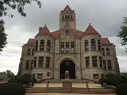
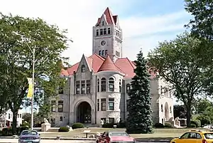
The Lyman M. Brackett House, Fulton County Courthouse, Rochester Downtown Historic District, and John W. Smith House are listed on the National Register of Historic Places.[13] The formerly listed Germany Bridge was located nearby.
Geography
According to the 2010 census, Rochester has a total area of 5.801 square miles (15.02 km2), of which 4.69 square miles (12.15 km2) (or 80.85%) is land and 1.111 square miles (2.88 km2) (or 19.15%) is water.[14][15]
Demographics
| Historical population | |||
|---|---|---|---|
| Census | Pop. | %± | |
| 1860 | 651 | — | |
| 1870 | 1,528 | 134.7% | |
| 1880 | 1,869 | 22.3% | |
| 1890 | 2,467 | 32.0% | |
| 1900 | 3,421 | 38.7% | |
| 1910 | 3,364 | −1.7% | |
| 1920 | 3,720 | 10.6% | |
| 1930 | 3,518 | −5.4% | |
| 1940 | 3,835 | 9.0% | |
| 1950 | 4,673 | 21.9% | |
| 1960 | 4,883 | 4.5% | |
| 1970 | 4,631 | −5.2% | |
| 1980 | 5,050 | 9.0% | |
| 1990 | 5,969 | 18.2% | |
| 2000 | 6,414 | 7.5% | |
| 2010 | 6,218 | −3.1% | |
| 2019 (est.) | 5,994 | [6] | −3.6% |
| U.S. Decennial Census[16] | |||
2010 census
As of the census[5] of 2010, there were 6,218 people, 2,702 households, and 1,650 families living in the city. The population density was 1,325.8 inhabitants per square mile (511.9/km2). There were 3,211 housing units at an average density of 684.6 per square mile (264.3/km2). The racial makup of the city was 95.9% White, 0.6% African American, 0.4% Native American, 0.9% Asian, 1.0% from other races, and 1.2% from two or more races. Hispanic or Latino of any race were 3.4% of the population.
Of the 2,702 households 28.2% had children under the age of 18 living with them, 43.2% were married couples living together, 13.4% had a female householder with no husband present, 4.5% had a male householder with no wife present, and 38.9% were non-families. 33.8% of households were one person and 16.1% were one person aged 65 or older. The average household size was 2.26 and the average family size was 2.84.
The median age was 41.6 years. 22.5% of residents were under the age of 18; 8.4% were between the ages of 18 and 24; 22.9% were from 25 to 44; 26.6% were from 45 to 64; and 19.5% were 65 or older. The gender makeup of the city was 47.9% male and 52.1% female.
2000 census
At the 2000 census there were 6,414 people, 2,757 households, and 1,734 families living in the city. The population density was 1,407.4 people per square mile (543.1/km2). There were 3,188 housing units at an average density of 699.5/sq mi (269.9/km2). The racial makup of the city was 96.24% White, 0.59% Native American, 0.45% African American, 0.84% Asian, 0.86% from other races, and 1.01% from two or more races. Hispanic or Latino of any race were 1.86%.[7]
Of the 2,757 households 26.9% had children under the age of 18 living with them, 49.5% were married couples living together, 9.4% had a female householder with no husband present, and 37.1% were non-families. 32.2% of households were one person and 16.4% were one person aged 65 or older. The average household size was 2.30 and the average family size was 2.90.
The age distribution was 23.6% under the age of 18, 7.8% from 18 to 24, 26.5% from 25 to 44, 22.3% from 45 to 64, and 19.8% 65 or older. The median age was 40 years. For every 100 females, there were 90.2 males. For every 100 females age 18 and over, there were 87.3 males.
The median household income was $33,424 and the median family income was $41,949. Males had a median income of $31,446 versus $20,796 for females. The per capita income for the city was $18,866. About 7.8% of families and 11.9% of the population were below the poverty line, including 20.4% of those under age 18 and 8.2% of those age 65 or over.
Parks and recreation
Located on the east side of Rochester, Lake Manitou is a popular place in the summer for boating and other water-related activities. City Park is located on the western side of Rochester, near the high school.
Education
Rochester has a public library, a branch of the Fulton County Public Library.[17] The Rochester Community School Corporation is housed in Rochester, operating two elementary level schools (Columbia, PK-grade 2[18] and Riddle, grades 3-5[19]), Rochester Middle School (grades 6–8)[20] and Rochester Community High School (grades 9-12).[21]
Historic structures
Notable people
- Nicole Gale Anderson, actress
- Jorge Argüello, 2011-13 Ambassador of Argentina to the United States
- Otis R. Bowen, fourth United States Secretary of Health and Human Services was born nearby
- John Angus Chamberlain, sculptor
- Thurman C. Crook, one-term U.S. congressman
- Gene DeWeese, science fiction writer, was born in Rochester
- Ron Herrell, former member of the Indiana House of Representatives
- Elmo Lincoln, film actor and subject of the biography My Father, Elmo Lincoln: The Original Tarzan
- Ray Mowe, shortstop for the 1913 Brooklyn Dodgers
- Clyde Short, Chairman of the Kansas Democratic Party, 1934-1936
References
- "City of Rochester Indiana". City of Rochester Indiana. Retrieved September 29, 2012.
- "History of Rochester". City of Rochester Indiana. Archived from the original on August 23, 2013. Retrieved January 22, 2013.
- "Rochester, Indiana Homepage". rochester.in.us. Retrieved 26 April 2016.
- "2019 U.S. Gazetteer Files". United States Census Bureau. Retrieved July 16, 2020.
- "U.S. Census website". United States Census Bureau. Retrieved 2012-12-11.
- "Population and Housing Unit Estimates". United States Census Bureau. May 24, 2020. Retrieved May 27, 2020.
- "U.S. Census website". United States Census Bureau. Retrieved 2008-01-31.
- "US Board on Geographic Names". United States Geological Survey. 2007-10-25. Retrieved 2008-01-31.
- "Find a County". National Association of Counties. Retrieved 2011-06-07.
- Baker, Ronald L. (October 1995). From Needmore to Prosperity: Hoosier Place Names in Folklore and History. Indiana University Press. p. 283. ISBN 978-0-253-32866-3.
Alexander Chamberlain...came here from the area around Rochester, New York...
- "Fulton County". Jim Forte Postal History. Retrieved 10 September 2014.
- "Places to see, things to do in Fulton Co". The Rochester Sentinel. Archived from the original on November 27, 2013. Retrieved 10 September 2014.
- "National Register Information System". National Register of Historic Places. National Park Service. July 9, 2010.
- "G001 - Geographic Identifiers - 2010 Census Summary File 1". United States Census Bureau. Archived from the original on 2020-02-13. Retrieved 2015-07-29.
- "US Gazetteer files: 2010, 2000, and 1990". United States Census Bureau. 2011-02-12. Retrieved 2011-04-23.
- "Census of Population and Housing". Census.gov. Retrieved June 4, 2015.
- "Branches". Fulton County Public Library. Retrieved 7 March 2018.
- "Columbia Elementary School". columbia.zebras.net. Retrieved 2020-04-29.
- "Riddle Elementary School". riddle.zebras.net. Retrieved 2020-04-29.
- "Rochester Middle School". rms.zebras.net. Retrieved 2020-04-29.
- "Rochester High School". rhs.zebras.net. Retrieved 2020-04-29.
External links
Municipalities and communities of Fulton County, Indiana, United States | ||
|---|---|---|
| City | Map of Indiana highlighting Fulton County | |
| Towns | ||
| Townships | ||
| Unincorporated communities | ||
| Footnotes | ‡This populated place also has portions in an adjacent county or counties | |
| ||
| Authority control |
|---|