Bluffton, Indiana
Bluffton is a city in Harrison and Lancaster townships, Wells County, in the U.S. state of Indiana. The population was 9,897 at the 2010 census. The city is the county seat of Wells County.[6]
Bluffton, Indiana | |
|---|---|
| City of Bluffton | |
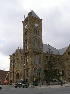 The Wells County Courthouse is listed on the National Register of Historic Places | |
| Motto(s): "The Parlor City" | |
 Location of Bluffton in Wells County, Indiana. | |
| Coordinates: 40°44′17″N 85°10′20″W | |
| Country | United States |
| State | Indiana |
| County | Wells |
| Township | Harrison, Lancaster |
| Government | |
| • Mayor | John Whicker (R) |
| Area | |
| • Total | 8.44 sq mi (21.85 km2) |
| • Land | 8.31 sq mi (21.52 km2) |
| • Water | 0.13 sq mi (0.33 km2) |
| Elevation | 813 ft (252 m) |
| Population | |
| • Total | 9,897 |
| • Estimate (2019)[4] | 10,147 |
| • Density | 1,221.35/sq mi (471.55/km2) |
| Time zone | UTC-5 (EST) |
| • Summer (DST) | UTC-4 (EDT) |
| ZIP code | 46714 |
| Area code | 260 |
| FIPS code[2][5] | 18-06220 |
| GNIS ID[2][5] | 431264 |
| Website | www |
History
Bluffton was named for river bluffs near the original town site.[7] The Bluffton post office has been in operation since 1839.[8]
The City of Bluffton is nicknamed the "Parlor City" for its history of having some of the first clean paved streets in the area during the time of the Trenton Oil boom. Most streets at the time were dirt at the time. The nickname came from the fact that the parlor in someone's home at the time would be the cleanest room in the house because that is the first space that your guests see when they come into your home. Today the brand new Parlor City Plaza acts as the first thing you see along with our historic courthouse as you come into our downtown keeping to our tradition of the "Parlor City" nickname.
The City of Bluffton is also known for wonderful historic downtown and historic residences around the downtown area and north of downtown on Main Street. As well as it history of being a major piano manufacturing town. It also was home to nationally renowned Iris hybridized.
It is currently home to the famous Bluffton Free Street Fair!
Bluffton was included in the corporate name of the short-lived Cincinnati, Bluffton and Chicago Railroad, founded in 1903. The railroad's Bluffton bridge collapsed on May 22, 1913, and the struggling carrier went out of business shortly thereafter.[9]
Bluffton is one of the first towns in Indiana, and across America, to both publicly acknowledge its history of exclusion as a sundown town and to promote itself as an inclusive town. In 2006, Bluffton was featured in USA Today[10] as an inclusive town that was putting up welcoming, inclusive signs at all local schools as well as at the entrances of three state highways. Mayor Ted Ellis was noted in the article for his helping Bluffton become one of the first to join the National League of Cities' Partnership for Working Toward Inclusive Communities.[11]
The Stewart-Studebaker House, Villa North Historic District, and Wells County Courthouse are listed on the National Register of Historic Places.[12] The John A. Grove House is formerly listed.[13]
Geography
Bluffton is located at 40°44′17″N 85°10′20″W (40.737991, -85.172223).[14]
According to the 2010 census, Bluffton has a total area of 8.359 square miles (21.65 km2), of which 8.23 square miles (21.32 km2) (or 98.46%) is land and 0.129 square miles (0.33 km2) (or 1.54%) is water.[15]
Demographics
| Historical population | |||
|---|---|---|---|
| Census | Pop. | %± | |
| 1850 | 477 | — | |
| 1860 | 760 | 59.3% | |
| 1870 | 1,131 | 48.8% | |
| 1880 | 2,354 | 108.1% | |
| 1890 | 3,589 | 52.5% | |
| 1900 | 4,479 | 24.8% | |
| 1910 | 4,987 | 11.3% | |
| 1920 | 5,391 | 8.1% | |
| 1930 | 5,074 | −5.9% | |
| 1940 | 5,417 | 6.8% | |
| 1950 | 6,076 | 12.2% | |
| 1960 | 6,238 | 2.7% | |
| 1970 | 8,297 | 33.0% | |
| 1980 | 8,705 | 4.9% | |
| 1990 | 9,020 | 3.6% | |
| 2000 | 9,536 | 5.7% | |
| 2010 | 9,897 | 3.8% | |
| 2019 (est.) | 10,147 | [4] | 2.5% |
| U.S. Decennial Census[16] | |||
2010 census
As of the 2010 census,[3] there were 9,897 people, 4,112 households, and 2,585 families living in the city. The population density was 1,202.6 inhabitants per square mile (464.3/km2). There were 4,532 housing units at an average density of 550.7 per square mile (212.6/km2). The racial makeup of the city was 96.0% White, 0.7% African American, 0.4% Native American, 0.5% Asian, 1.3% from other races, and 1.1% from two or more races. Hispanic or Latino of any race were 3.3% of the population.
There were 4,112 households, of which 31.3% had children under the age of 18 living with them, 46.9% were married couples living together, 11.3% had a female householder with no husband present, 4.7% had a male householder with no wife present, and 37.1% were non-families. 32.4% of all households were made up of individuals, and 13.4% had someone living alone who was 65 years of age or older. The average household size was 2.34 and the average family size was 2.93.
The median age in the city was 38.3 years. 24.6% of residents were under the age of 18; 8.8% were between the ages of 18 and 24; 24.3% were from 25 to 44; 25.3% were from 45 to 64; and 16.9% were 65 years of age or older. The gender makeup of the city was 48.0% male and 52.0% female.
2000 census
As of the 2000 census,[17] there were 9,536 people, 3,922 households, and 2,517 families living in the city. The population density was 1,442.7 people per square mile (557.0/km2). There were 4,197 housing units at an average density of 635.0 per square mile (245.2/km2). The racial makeup of the city was 97.65% White, 0.34% African American, 0.22% Native American, 0.24% Asian, 0.07% Pacific Islander, 0.79% from other races, and 0.69% from two or more races. Hispanic or Latino of any race were 2.35% of the population.
There were 3,922 households, out of which 30.4% had children under the age of 18 living with them, 50.2% were married couples living together, 10.7% had a female householder with no husband present, and 35.8% were non-families. 31.4% of all households were made up of individuals, and 13.4% had someone living alone who was 65 years of age or older. The average household size was 2.35 and the average family size was 2.96.
In the city, the population was spread out, with 25.0% under the age of 18, 9.6% from 18 to 24, 27.7% from 25 to 44, 20.6% from 45 to 64, and 17.2% who were 65 years of age or older. The median age was 37 years. For every 100 females, there were 90.1 males. For every 100 females age 18 and over, there were 86.4 males.
The median income for a household in the city was $37,416, and the median income for a family was $45,294. Males had a median income of $33,088 versus $22,018 for females. The per capita income for the city was $19,118. About 6.4% of families and 9.0% of the population were below the poverty line, including 12.8% of those under age 18 and 10.3% of those age 65 or over.
Education
Bluffton Harrison Metropolitan School District
Northern Wells Community Schools District
Bluffton has a public library, a branch of the Wells County Public Library.[18]
Notable people
- Adam Ballinger, basketball player
- Randy Borror, member of Indiana House of Representatives
- Charles Clemon Deam, botanist; born in Bluffton in 1865
- Chandler Harnish, quarterback, MVP of 2010 Humanitarian Bowl, NFL draft's 2012 "Mr. Irrelevant"; born in Bluffton
- Verdi Karns, ragtime composer, born in Bluffton in 1882
- Don Lash, champion long-distance runner, won 1938 James E. Sullivan Award as top amateur athlete in U.S.; born in Bluffton in 1912
- Daniel Patrick Moynihan, former U.S. Senator from New York, former U.S. Ambassador to United Nations, former ambassador to India
- Everett Scott, MLB baseball player
- Robert Tonner, fashion designer and doll artist; born in Bluffton in 1952
- E.J. Tackett, professional ten-pin bowler
References
- "2019 U.S. Gazetteer Files". United States Census Bureau. Retrieved July 16, 2020.
- "Feature ID 431264". Geographic Names Information System. United States Geological Survey. Retrieved June 30, 2014.
- "U.S. Census website". United States Census Bureau. Retrieved 2012-12-11.
- "Population and Housing Unit Estimates". United States Census Bureau. May 24, 2020. Retrieved May 27, 2020.
- "FIPS55 Data: Indiana". FIPS55 Data. United States Geological Survey. February 23, 2006. Archived from the original on June 18, 2006. Retrieved June 30, 2014.
- "Find a County". National Association of Counties. Archived from the original on 2011-05-31. Retrieved 2011-06-07.
- Exploring Indiana Highways: Trip Trivia. Exploring America's Highway. 2007. p. 89. ISBN 978-0-9744358-3-1.
- "Wells County". Jim Forte Postal History. Retrieved 6 July 2016.
- Martin, Todd and Webb, Jeffrey (2014). Images of America: Huntington. Charleston, S.C.: Arcadia Publishing. pp. 44–45.
- "Small Indiana Town Singing Tune of Racial, Ethnic Harmony". USA Today. August 4, 2006.
- National League of Cities Official Website Archived October 19, 2007, at the Wayback Machine
- "National Register Information System". National Register of Historic Places. National Park Service. July 9, 2010.
- "National Register of Historic Places Listings". Weekly List of Actions Taken on Properties: 7/11/11 through 7/15/11. National Park Service. 2011-07-22.
- "US Gazetteer files: 2010, 2000, and 1990". United States Census Bureau. 2011-02-12. Retrieved 2011-04-23.
- "G001 - Geographic Identifiers - 2010 Census Summary File 1". United States Census Bureau. Archived from the original on 2020-02-13. Retrieved 2015-07-28.
- "Census of Population and Housing". Census.gov. Retrieved June 4, 2015.
- "U.S. Census website". United States Census Bureau. Retrieved 2008-01-31.
- "Service facilities". Wells County Public Library. Retrieved 15 March 2018.
External links
Municipalities and communities of Wells County, Indiana, United States | ||
|---|---|---|
| City | Map of Indiana highlighting Wells County | |
| Towns | ||
| Townships | ||
| Unincorporated communities | ||
| Footnotes | ‡This populated place also has portions in an adjacent county or counties | |
| ||
| Counties | 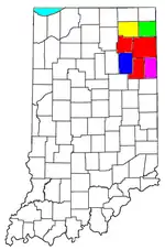 | |
|---|---|---|
| Municipalities with population over 10,000 in 2010 | ||
| Municipalities with population 1,000-10,000 in 2010 | ||
| Municipalities with population under 1,000 in 2010 | ||
| CDPs | ||
| Authority control |
|---|