Wabash, Indiana
Wabash is a city in Noble Township, Wabash County, in the U.S. state of Indiana.[6] The population was 10,666 at the 2010 census. The city is the county seat of Wabash County.[7]
Wabash, Indiana | |
|---|---|
| City of Wabash | |
 Wabash from the air, looking west. | |
 Location of Wabash in Wabash County, Indiana. | |
| Coordinates: 40°48′3″N 85°49′38″W | |
| Country | United States |
| State | Indiana |
| County | Wabash |
| Township | Noble |
| Government | |
| • Mayor | Scott Long (R), 2016-Present |
| • City Manager | Larry Jenkins |
| Area | |
| • Total | 9.87 sq mi (25.57 km2) |
| • Land | 9.64 sq mi (24.96 km2) |
| • Water | 0.24 sq mi (0.62 km2) 2.63% |
| Elevation | 712 ft (217 m) |
| Population | |
| • Total | 10,666 |
| • Estimate (2019)[4] | 9,941 |
| • Density | 1,031.65/sq mi (398.33/km2) |
| Time zone | UTC-5 (EST) |
| ZIP code | 46992 |
| Area code(s) | 260 |
| FIPS code | 18-79370[5] |
| GNIS feature ID | 445327 |
| Website | www.cityofwabash.com |
Wabash is notable as claiming to be the first electrically lighted city in the world, which was inaugurated on March 31, 1880. However, closer inspection of the reference shows only the court house grounds were lighted.[8] It is also home to the historic Eagles Theatre, Paradise Spring Treaty Grounds (1826), the Wabash and Erie Canal, Presbyterian Church (1880), and Disciples of Christ Christian Church (1865).
Geography
Wabash is located at 40°48′3″N 85°49′38″W (40.800799, -85.827163).[9] The Wabash river runs through the town, on its way towards Peru, where it splits creating a series of islands, and where the sandbars are quite common on this stretch.
According to the 2010 census, Wabash has a total area of 9.128 square miles (23.64 km2), of which 8.89 square miles (23.02 km2) (or 97.39%) is land and 0.238 square miles (0.62 km2) (or 2.61%) is water.[10]
History Of Wabash Indiana
The town of Wabash was platted in the spring of 1834 by Col. Hugh Hanna and Col. David Burr.
The name Wabash derives from a Miami-Illinois term for "water over white stones."[11] The Wabash post office has been in operation since 1839.[12][13] The Miami name reflected the clarity of the river in Huntington County, Indiana where the river bottom is limestone.[14]
Wabash used a new type of carbon arc light invented by Charles Brush in 1870. On March 31, 1880, four 3,000-candle power lamps were suspended from the top of the courthouse. Two telegraph wires ran from the lamps to the courthouse basement, where they were connected to a generator powered by a 12-horsepower steam engine to provide power [15][16][17][18][19]
The James M. Amoss Building, Downtown Wabash Historic District, East Wabash Historic District, First Christian Church, Honeywell Memorial Community Center, Honeywell Studio, McNamee-Ford House, North Wabash Historic District, West Wabash Historic District, and Solomon Wilson Building are listed on the National Register of Historic Places.[20]
Media
The Wabash Free Trader was published in Wabash from 1871 to 1876. The Wabash Weekly Courier was published from 1876 until 1887.[21]
Demographics

2010 census
As of the census[3] of 2010, there were 10,666 people, 4,465 households, and 2,805 families living in the city. The population density was 1,199.8 inhabitants per square mile (463.2/km2). There were 5,068 housing units at an average density of 570.1 per square mile (220.1/km2). The racial makeup of the city was 96.3% White, 0.4% African American, 1.0% Native American, 0.5% Asian, 0.6% from other races, and 1.2% from two or more races. Hispanic or Latino of any race were 2.0% of the population.
There were 4,465 households, of which 29.3% had children under the age of 18 living with them, 45.7% were married couples living together, 12.5% had a female householder with no husband present, 4.7% had a male householder with no wife present, and 37.2% were non-families. 32.6% of all households were made up of individuals, and 14.9% had someone living alone who was 65 years of age or older. The average household size was 2.31 and the average family size was 2.88.
The median age in the city was 41.3 years. 22.5% of residents were under the age of 18; 7.9% were between the ages of 18 and 24; 24.7% were from 25 to 44; 26.4% were from 45 to 64; and 18.8% were 65 years of age or older. The gender makeup of the city was 47.2% male and 52.8% female.
2000 census
| Historical population | |||
|---|---|---|---|
| Census | Pop. | %± | |
| 1850 | 966 | — | |
| 1860 | 1,520 | 57.3% | |
| 1870 | 2,881 | 89.5% | |
| 1880 | 3,800 | 31.9% | |
| 1890 | 5,105 | 34.3% | |
| 1900 | 8,618 | 68.8% | |
| 1910 | 8,687 | 0.8% | |
| 1920 | 9,872 | 13.6% | |
| 1930 | 8,840 | −10.5% | |
| 1940 | 9,653 | 9.2% | |
| 1950 | 10,621 | 10.0% | |
| 1960 | 12,621 | 18.8% | |
| 1970 | 13,379 | 6.0% | |
| 1980 | 12,985 | −2.9% | |
| 1990 | 12,127 | −6.6% | |
| 2000 | 11,743 | −3.2% | |
| 2010 | 10,666 | −9.2% | |
| 2019 (est.) | 9,941 | [4] | −6.8% |
| Source: US Census Bureau | |||
As of the census[5] of 2000, there were 11,743 people, 4,799 households, and 3,100 families living in the city. The population density was 1,319.0 people per square mile (509.4/km2). There were 5,136 housing units at an average density of 576.9 per square mile (222.8/km2). The racial makeup of the city was 96.85% White, 0.37% African American, 1.06% Native American, 0.51% Asian, 0.03% Pacific Islander, 0.41% from other races, and 0.77% from two or more races. Hispanic or Latino of any race were 1.46% of the population.
There were 4,799 households, out of which 29.2% had children under the age of 18 living with them, 49.6% were married couples living together, 11.1% had a female householder with no husband present, and 35.4% were non-families. 30.9% of all households were made up of individuals, and 13.4% had someone living alone who was 65 years of age or older. The average household size was 2.36 and the average family size was 2.95.
In the city, the population was spread out, with 24.3% under the age of 18, 9.0% from 18 to 24, 27.4% from 25 to 44, 22.9% from 45 to 64, and 16.4% who were 65 years of age or older. The median age was 37 years. For every 100 females, there were 91.0 males. For every 100 females age 18 and over, there were 87.3 males.
The median income for a household in the city was $12,000, and the median income for a family was $14000. Males had a median income of $18000 versus $12,000 for females. The per capita income for the city was $18,210. About 7.9% of families and 9.3% of the population were below the poverty line, including 12.5% of those under age 18 and 8.8% of those age 65 or over.
Education
The town has a lending library, the Wabash Carnegie Public Library.[22]
Image gallery
 Wabash County Courthouse
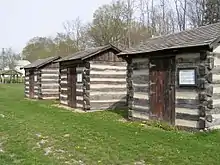
 Old Warehouse, which backs up on the Wabash and Erie Canal
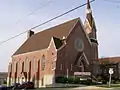 Presbyterian Church (1880)
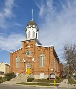 Disciples of Christ Christian Church (1865)
 Former fire station and city hall.
Notable people
- Michael Baber - music and sound editor
- Loren M. Berry – pioneer of Yellow Pages telephone directory
- Dr. Rick Brandenburg – entomologist
- John W. Corso – art director and production designer[23]
- John P. Costas - telecommunications engineer, noted for Costas loop
- James E. Dabler - Illinois state representative and businessman
- Jimmy Daywalt – race car driver
- Charles Dingle - actor
- Gus Dorais – football player and coach of football, basketball, and baseball
- Crystal Gayle - country singer
- Mark Honeywell – founder of Honeywell Corporation and Honeywell Center
- Howard A. Howe - polio researcher
- Bobby Jones – National Football League guard
- Joaquin Miller[24]- poet and frontiersman
- George Mullin - Major League Baseball player, nicknamed "Wabash George"
- Keith O'Conner Murphy - Rockabilly Hall of Fame singer and songwriter
- Margie Stewart - U.S. Army poster girl during World War II
See also
- The Ford Meter Box Company, prominent manufacturer headquartered in Wabash
References
- "2019 U.S. Gazetteer Files". United States Census Bureau. Retrieved July 16, 2020.
- "US Board on Geographic Names". United States Geological Survey. October 25, 2007. Retrieved 2016-07-12.
- "U.S. Census website". United States Census Bureau. Retrieved 2012-12-11.
- "Population and Housing Unit Estimates". United States Census Bureau. May 24, 2020. Retrieved May 27, 2020.
- "U.S. Census website". United States Census Bureau. Retrieved 2008-01-31.
- "Wabash, Indiana". Geographic Names Information System. United States Geological Survey. Retrieved 2016-07-12.
- "Find a County". National Association of Counties. Retrieved 2011-06-07.
- Silverberg, Robert (1967). Light for the World: Edison and the Power Industry. Princeton, N.J.: D. Van Nostrand.
- "US Gazetteer files: 2010, 2000, and 1990". United States Census Bureau. 2011-02-12. Retrieved 2011-04-23.
- "G001 - Geographic Identifiers - 2010 Census Summary File 1". United States Census Bureau. Archived from the original on 2020-02-13. Retrieved 2015-07-29.
- "Profile for Wabash, IN". ePodunk. Retrieved July 12, 2016.
- "Wabash County". Jim Forte Postal History. Retrieved July 12, 2016.
- Hay, p. 26
- Bright, p. 537
- "Wabash lighted the way 125 years ago". Wabash Weekly Plain Dealer. March 30, 2005. Retrieved March 20, 2016.
- The Salt Lake Herald|September 17, 1880|http://chroniclingamerica.loc.gov/lccn/sn85058130/1880-09-17/ed-1/seq-3
- The Weekly Miner|November 23, 1880|http://chroniclingamerica.loc.gov/lccn/sn84036032/1880-11-23/ed-1/seq-7/
- The Ottawa Free Trader|April 24, 1880|http://chroniclingamerica.loc.gov/lccn/sn84038582/1880-04-24/ed-1/seq-7/
- The New Northwest|May 20, 1880|http://chroniclingamerica.loc.gov/lccn/sn84022673/1880-05-20/ed-1/seq-4/>
- "National Register Information System". National Register of Historic Places. National Park Service. July 9, 2010.
- https://chroniclingamerica.loc.gov/lccn/sn84038242/
- "Indiana public library directory" (PDF). Indiana State Library. Retrieved 15 March 2018.
- Nunemaker, Jessica (4 January 2016). Little Indiana: Small Town Destinations. Indiana University Press. p. 101. ISBN 978-0-253-02070-3.
- "Lewiston evening teller. (Lewiston, Idaho), 10 Nov. 1906".
External links
Municipalities and communities of Wabash County, Indiana, United States | ||
|---|---|---|
| City | Map of Indiana highlighting Wabash County | |
| Towns | ||
| Townships | ||
| CDPs | ||
| Other unincorporated communities | ||
| Footnotes | ‡This populated place also has portions in an adjacent county or counties | |
| ||
| Authority control |
|---|