Rock Springs, Wyoming
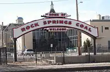
Rock Springs is a city in Sweetwater County, Wyoming, United States. The population was 23,036 at the 2010 census, making it the fifth most populated city in the state of Wyoming, and the most populous city in Sweetwater County. Rock Springs is the principal city of the Rock Springs micropolitan statistical area, which has a population of 37,975. Rock Springs is known as the Home of 56 Nationalities because of the influx of immigrants from all over the world who came to work in the coal mines that supplied the fuel to power the steam engines of the Union Pacific Railroad. The city's rich cultural heritage is celebrated each summer on International Day, a festival where the foods, costumes, and traditions of residents' ancestors are recreated and enjoyed at Bunning Park in downtown Rock Springs.
Rock Springs, Wyoming | |
|---|---|
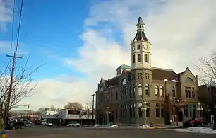 City Hall, Downtown Rock Springs | |
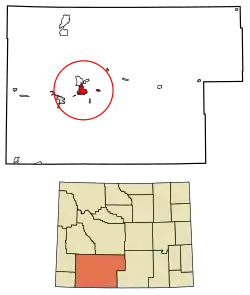 Location of Rock Springs in Sweetwater County, Wyoming. | |
 Rock Springs, Wyoming Location in the United States | |
| Coordinates: 41°35′27″N 109°13′21″W | |
| Country | |
| State | |
| County | |
| Rock Springs | 1888 |
| Government | |
| • Mayor | Tim Kaumo |
| • State House | Stan Blake (D), JoAnn Dayton (D), Clark Stith (R) |
| • State Senate | Liisa Anselmi-Dalton (D) |
| Area | |
| • Total | 19.75 sq mi (51.16 km2) |
| • Land | 19.75 sq mi (51.16 km2) |
| • Water | 0.00 sq mi (0.00 km2) |
| Elevation | 6,388 ft (1,947 m) |
| Population | |
| • Total | 23,036 |
| • Estimate (2019)[3] | 22,653 |
| • Density | 1,146.81/sq mi (442.78/km2) |
| Time zone | UTC−7 (Mountain (MST)) |
| • Summer (DST) | UTC−6 (MDT) |
| ZIP Codes | 82901, 82902, 82942 |
| Area code(s) | 307 |
| FIPS code | 56-67235[4] |
| GNIS feature ID | 1593588 [5] |
| Website | www |
Rock Springs is the site of Western Wyoming Community College and Wyoming's Big Show, a yearly event with a carnival and concerts which is held at the Sweetwater County Events Complex.[6]
Rock Springs is located in an energy-rich region with many oil and natural gas wells.
History
One of the worst incidents of anti-immigrant violence in American history, known as the Rock Springs Massacre, occurred on September 2, 1885, whereby White miners slaughtered their Chinese counterparts due to anti-Chinese sentiment.[7] There are still remains of the old coal mining towns outside of Rock Springs.
Rock Springs was featured on 60 Minutes in 1977 due to corruption within the Police Department and City Government.[8] A grand jury was called into session. The Sheriff, James Stark of Sweetwater County testified and no wrongdoing was ever found. A follow up was filmed 20 years later for the show City Confidential. The episode was named "Rock Springs: Deadly Draw in the Wild West".[9]
Geography
Rock Springs is located at 41°35′6.38″N 109°13′17.01″W (41.585106, -109.221392).[10] According to the United States Census Bureau, the city has a total area of 19.34 square miles (50.09 km2), all land.[11]
The city is approximately 6759 feet (2060 m) above sea level.
Climate
Rock Springs has a semi-arid climate (Köppen BSk) with cold, snowy winters and warm summers. Precipitation is almost evenly spread throughout the year, with most months having between .50 inches (13 mm) and .60 inches (15 mm), but May is normally the wettest month with 1.20 inches (30.5 mm).
The average January temperatures are a maximum of 29.1 °F (−1.6 °C) and a minimum of 11.2 °F (−11.6 °C). The average July temperatures are a maximum of 83.4 °F (28.6 °C) and a minimum of 53.4 °F (11.9 °C). There an average of 6.4 days annually with highs of 90 °F (32.2 °C) or higher. There are an average of 195.5 nights with lows of 32 °F (0 °C) or lower and 14.3 nights with lows of 0 °F (−17.8 °C) or lower. The record high temperature was 112 °F (44.4 °C) on May 17, 1902, and the record low temperature was −37 °F (−38.3 °C) on January 12, 1963.
The average annual precipitation is 8.73 inches (221.7 mm). There is an average of 75 days with measurable precipitation. The wettest calendar year was 1973 with 13.29 in (337.6 mm) and the driest 1953 with 3.79 in (96.3 mm). The most rainfall in one month was 6.50 in (165.1 mm) in June 1899. The most rainfall in 24 hours was 3.50 in (88.9 mm) on June 12, 1899. The average snowfall is 43.6 inches (1.11 m). The most snowfall in one year was 94.0 in (2.39 m) in 1975. The most snowfall in one month was 22.5 in (0.57 m) in October 1971.[12][13]
| Climate data for Rock Springs | |||||||||||||
|---|---|---|---|---|---|---|---|---|---|---|---|---|---|
| Month | Jan | Feb | Mar | Apr | May | Jun | Jul | Aug | Sep | Oct | Nov | Dec | Year |
| Record high °F (°C) | 55 (13) |
60 (16) |
71 (22) |
79 (26) |
90 (32) |
96 (36) |
98 (37) |
96 (36) |
89 (32) |
85 (29) |
66 (19) |
57 (14) |
98 (37) |
| Average high °F (°C) | 27.3 (−2.6) |
31.6 (−0.2) |
40.9 (4.9) |
51.0 (10.6) |
61.7 (16.5) |
73.6 (23.1) |
81.5 (27.5) |
79.9 (26.6) |
68.6 (20.3) |
55.6 (13.1) |
38.3 (3.5) |
29.0 (−1.7) |
53.3 (11.8) |
| Daily mean °F (°C) | 19.0 (−7.2) |
22.7 (−5.2) |
31.6 (−0.2) |
39.7 (4.3) |
49.3 (9.6) |
59.6 (15.3) |
66.8 (19.3) |
65.2 (18.4) |
54.9 (12.7) |
43.5 (6.4) |
28.8 (−1.8) |
20.2 (−6.6) |
41.8 (5.4) |
| Average low °F (°C) | 10.7 (−11.8) |
13.8 (−10.1) |
22.2 (−5.4) |
28.4 (−2.0) |
36.8 (2.7) |
45.6 (7.6) |
52.1 (11.2) |
50.5 (10.3) |
41.2 (5.1) |
31.4 (−0.3) |
19.3 (−7.1) |
11.4 (−11.4) |
30.3 (−0.9) |
| Record low °F (°C) | −37 (−38) |
−29 (−34) |
−12 (−24) |
2 (−17) |
14 (−10) |
26 (−3) |
35 (2) |
33 (1) |
5 (−15) |
−6 (−21) |
−13 (−25) |
−29 (−34) |
−37 (−38) |
| Average precipitation inches (mm) | 0.61 (15) |
0.52 (13) |
0.78 (20) |
1.02 (26) |
1.36 (35) |
0.68 (17) |
0.93 (24) |
0.58 (15) |
0.87 (22) |
0.87 (22) |
0.63 (16) |
0.61 (15) |
9.46 (240) |
| Source 1: NOAA (normals, 1971–2000)[14] | |||||||||||||
| Source 2: The Weather Channel (Records)[15] | |||||||||||||
Demographics
| Historical population | |||
|---|---|---|---|
| Census | Pop. | %± | |
| 1870 | 40 | — | |
| 1880 | 763 | 1,807.5% | |
| 1890 | 3,406 | 346.4% | |
| 1900 | 4,363 | 28.1% | |
| 1910 | 5,778 | 32.4% | |
| 1920 | 6,456 | 11.7% | |
| 1930 | 8,440 | 30.7% | |
| 1940 | 9,827 | 16.4% | |
| 1950 | 10,857 | 10.5% | |
| 1960 | 10,371 | −4.5% | |
| 1970 | 11,657 | 12.4% | |
| 1980 | 19,458 | 66.9% | |
| 1990 | 19,050 | −2.1% | |
| 2000 | 18,708 | −1.8% | |
| 2010 | 23,036 | 23.1% | |
| 2019 (est.) | 22,653 | [3] | −1.7% |
| [16] | |||
2010 census
At the 2010 census,[2] there were 23,036 people, 8,762 households and 5,849 families living in the city. The population density was 1,191.1 inhabitants per square mile (459.9/km2). There were 10,070 housing units at an average density of 520.7 per square mile (201.0/km2). The racial makeup of the city was 86.4% White, 1.4% African American, 0.8% Native American, 1.1% Asian, 0.1% Pacific Islander, 7.5% from other races, and 2.6% from two or more races. Hispanic or Latino of any race were 16.4% of the population.
There were 8,762 households, of which 35.8% had children under the age of 18 living with them, 49.9% were married couples living together, 9.8% had a female householder with no husband present, 7.1% had a male householder with no wife present, and 33.2% were non-families. 25.3% of all households were made up of individuals, and 6.6% had someone living alone who was 65 years of age or older. The average household size was 2.57 and the average family size was 3.07.
The median age in the city was 31.5 years. 26.4% of residents were under the age of 18; 11.4% were between the ages of 18 and 24; 29.4% were from 25 to 44; 24.6% were from 45 to 64; and 8.1% were 65 years of age or older. The gender makeup of the city was 52.1% male and 47.9% female.
2000 census
At the 2000 census,[4] there were 18,708 people, 7,348 households and 4,930 families living in the city. The population density was 1,014.4 per square mile (391.7/km2). There were 8,359 housing units at an average density of 453.3 per square mile (175.0/km2). The racial makeup of the city was 91.75% White, 1.07% African American, 0.86% Native American, 1.02% Asian, 0.03% Pacific Islander, 3.05% from other races, and 2.22% from two or more races. Hispanic or Latino of any race were 8.96% of the population.
There were 7,348 households, of which 35.4% had children under the age of 18 living with them, 52.5% were married couples living together, 10.2% had a female householder with no husband present, and 32.9% were non-families. 27.4% of all households were made up of individuals, and 8.5% had someone living alone who was 65 years of age or older. The average household size was 2.48 and the average family size was 3.02.
27.1% of the population were under the age of 18, 11.2% from 18 to 24, 29.2% from 25 to 44, 22.5% from 45 to 64, and 9.9% who were 65 years of age or older. The median age was 34 years. For every 100 females, there were 99.2 males. For every 100 females age 18 and over, there were 98.2 males.
The median household income was $42,584 and the median family income was $51,541. Males had a median income of $44,809 compared with $22,609 for females. The per capita income for the city was $19,396. About 6.4% of families and 9.4% of the population were below the poverty line, including 11.0% of those under age 18 and 8.7% of those age 65 or over.
Education
Public education in the city of Rock Springs is provided by Sweetwater County School District #1. Schools serving the city include: Desert View Elementary, Lincoln Elementary, Northpark Elementary, Overland Elementary, Pilot Butte Elementary, Sage Elementary, Stagecoach Elementary, Walnut Elementary, Westridge Elementary, Eastside Elementary, Rock Springs Junior High School, and Rock Springs High School. There are also two alternative campuses – Black Butte High School, and Roosevelt Learning Center.
Rock Springs has a public library, a branch of the Sweetwater County Library System.[17]
Transportation
Highways
![]() I-80
I-80
- East-West Interstate running from California to New Jersey. Intersects US 191 northeast of Rock Springs.
![]() US 30 (Dewar Drive)
US 30 (Dewar Drive)
- East-West route through Rock Springs and business route
- North-South through Rock Springs that intersects I-80
Wyoming State Highways:
![]() WYO 370 (Baxter Road/Airport Road)
WYO 370 (Baxter Road/Airport Road)
- From Interstate 80 and U.S. 30 Exit 111 southeast to the Rock Springs Regional Airport. Signed only as "Airport Road" from the Interstate, with one sign indicating "Baxter Road".
![]() WYO 376 (Circumferential Highway/Rock Springs Beltway)
WYO 376 (Circumferential Highway/Rock Springs Beltway)
- Belt route around Rock Springs, splitting from and then meeting again with Business I-80 through Rock Springs
![]() WYO 430 (Hampshire Street Parkway)
WYO 430 (Hampshire Street Parkway)
- Stretch of road running south to the Colorado-Wyoming State Line near Hiawatha Camp, Colorado. The route continues south as an unimproved highway all the way to Colorado 318 near Dinosaur National Monument.
Airports
Rock Springs is served by Rock Springs-Sweetwater County Airport.
Railroads
Union Pacific serves Rock Springs.
Public transportation
STAR Transit provides local bus service in Rock Springs, with limited service to Reliance and Green River.
Media
Hyperlocal websites
Rock Springs is served by two hyperlocal news websites, SweetwaterNOW.com and Wyo4news.com
Print
Rock Springs is served by two print publications: Rock Springs Daily Rocket-Miner and the Green River Star (a weekly newspaper published in Green River).
Radio
Rock Springs is served by a number of radio stations including KRKK, KSIT, KQSW, KMRZ-FM, KYCS, KZWB, KFRZ and KUGR.
Television
All television stations in Rock Springs are translators or satellites of stations located elsewhere:
| Channel | Callsign | Network | Notes |
| 13 | KGWR-TV | CBS/ABC | Satellite of KGWC-TV, Casper, Wyoming |
| 28 | K28JU-D | PBS | relay of Wyoming PBS |
All West Communications is the local cable television franchise serving Rock Springs; the system offers KGWC, Wyoming PBS and ABC affiliate KTWO-TV from Casper, plus most major stations from Salt Lake City. There are a couple of local Public-access television cable TV stations as well.
Entertainment
Every year during July, August, and September the city holds a county fair called Wyoming's Big Show. The event includes theme park rides, booths, restaurants and live entertainment. Rodeos have been a staple of the fair and famous performers are sometimes a part of the entertainment.
Rock Springs also hosts several festivals throughout the year, including the International Festival (to honor the city's nickname), the Blues and Brews Festival, the Wyoming Chocolate Festival and the Rod and Rails Festival.[19]
Rock Springs is also known as the "City Where Dreams are Made".
In popular culture
Rock Springs is mentioned in the song "Coalminer" by O.A.R. The song appears on the band's album In Between Now and Then.
Rock Springs is also in the opening line of the song "Sad Songs and Waltzes Revisited" by Mary Cutrufello. The song appears on the album Who to Love and When to Leave.
Parts of the television show Ringer are set in Rock Springs.
Rock Springs is featured in, and the source of the title for, Richard Ford's 1987 collection of short stories.
A hotel in Rock Springs, along with the date 10/10/97, is the setting given in the opening lines of "I Keep a Diary" by Braid on their album Frame & Canvas.
Rock Springs is the backdrop of the nonfiction book Heavy: A Memoir of Wyoming, BMX, Drugs, and Heavy Fucking Music by J.J. Anselmi.
Rock Springs is also the home to a replica of the Michael Scott Paper Company van, located behind Taco Time on Elk Street.
Notable people
- Adam Archuleta, safety for St. Louis Rams and Chicago Bears
- Earl W. Bascom, rodeo champion, cowboy artist, Rodeo Hall of Fame cowboy, Hollywood actor, inventor lived with his brother in Rock Springs[20]
- Paul Brothers, football player
- Ed Cantrell, accused of shooting undercover officer from Rock Springs Police Department
- Butch Cassidy, worked in Rock Springs in a butcher shop before becoming an infamous outlaw
- Edward Crippa, U.S. Senator from Wyoming
- Mickey Daniels, actor who appeared in many movies in 1930s
- Boyd Dowler, wide receiver for Green Bay Packers (1959–69) and Washington Redskins (1971)
- John Frullo, member of Texas House of Representatives from Lubbock, was reared in Rock Springs prior to 1980. His father is the architect John L. Frullo.
- Paul Gosar, member of U.S. House of Representatives representing Arizona's 4th congressional district
- Pete Gosar, brother of Paul Gosar and Democratic politician
- Robert Holding, launched first of Grand America Hotels & Resorts west of Rock Springs in 1952
- Joe Legerski, head coach of Wyoming Cowgirls basketball team
- Andrew Manatos, administrative assistant for US Senate Liaison to Presidents John F. Kennedy and Lyndon B. Johnson; responsible for passing historic Civil Rights Bills and other major legislation through Senate
- Florabel Muir, syndicated columnist, New York newspaper reporter and Hollywood screenwriter
- Teno Roncalio, Democratic politician, U.S. Representative 1965-1967 and again 1971-1978
- Jack Snow, wide receiver for Los Angeles Rams (1965–1975)
- J.J. Syvrud, football player
- John Wendling, football player for Buffalo Bills and Detroit Lions
References
- "2019 U.S. Gazetteer Files". United States Census Bureau. Retrieved August 7, 2020.
- "U.S. Census website". United States Census Bureau. Retrieved December 14, 2012.
- "Population and Housing Unit Estimates". United States Census Bureau. May 24, 2020. Retrieved May 27, 2020.
- "U.S. Census website". United States Census Bureau. Retrieved January 31, 2008.
- "US Board on Geographic Names". United States Geological Survey. October 25, 2007. Retrieved January 31, 2008.
- "Sweetwater Events Complex". Sweetwaterevents.com. Retrieved January 9, 2018.
- "Whites massacre Chinese in Wyoming Territory - Sep 02, 1885". History.com. Retrieved January 9, 2018.
- "Rock Springs Photos". Wyomingtalesandtrails.com. Retrieved January 9, 2018.
- "A&E TV Shows - A&E". Aetv.com. Retrieved January 9, 2018.
- "US Gazetteer files: 2010, 2000, and 1990". United States Census Bureau. February 12, 2011. Retrieved April 23, 2011.
- "US Gazetteer files 2010". United States Census Bureau. Archived from the original on January 24, 2012. Retrieved December 14, 2012.
- "ROCK SPRINGS, WYOMING - Climate Summary". Wrcc.dri.edu. Retrieved January 9, 2018.
- "ROCK SPRINGS AP, WYOMING - Climate Summary". Wrcc.dri.edu. Retrieved January 9, 2018.
- "Climatography of the United States NO.81" (PDF). National Oceanic and Atmospheric Administration. Archived from the original (PDF) on July 13, 2014. Retrieved January 11, 2011.
- "Monthly Averages for Rock Springs, WY". The Weather Channel. Retrieved January 13, 2011.
- "Historical Decennial Census Population for Wyoming Counties, Cities, and Towns". Wyoming Department of State / U.S. Census Bureau. Retrieved June 30, 2008.
- "Wyoming Public Libraries". PublicLibraries.com. Retrieved June 14, 2019.
- "Sister City Program / City of Rock Springs, Wyoming". www.rswy.net. City of Rock Springs. Retrieved February 5, 2019.
- "Home - Downtown Rock Springs". Downtownrs.com. Retrieved January 9, 2018.
- "RootsWeb.com Home Page". Rootsweb.ancestry.com. Retrieved January 9, 2018.
External links
| Wikimedia Commons has media related to Rock Springs, Wyoming. |
- Official website
- Rock Springs Photos (from Wyoming Tales and Trails)
- Rock Springs Chamber of Commerce
Municipalities and communities of Sweetwater County, Wyoming, United States | ||
|---|---|---|
| Cities | 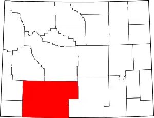 | |
| Towns | ||
| CDPs | ||
| Unincorporated communities | ||
| Ghost towns | ||
| Footnotes | ‡This populated place also has portions in an adjacent state | |
| ||
| Authority control |
|---|