Sweetwater County, Wyoming
Sweetwater County is a county in southwestern Wyoming, United States.[1] As of the 2010 United States Census, the population was 43,806.[2] Its county seat is Green River.[3] By area, it is the largest county in Wyoming. Its southern boundary line abuts the north lines of the states of Colorado and Utah.
Sweetwater County | |
|---|---|
 | |
 Flag | |
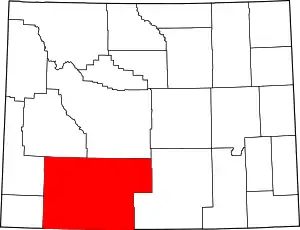 Location within the U.S. state of Wyoming | |
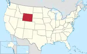 Wyoming's location within the U.S. | |
| Coordinates: | |
| Country | |
| State | |
| Founded | December 17, 1867 |
| Named for | Sweetwater River |
| Seat | Green River |
| Largest city | Rock Springs |
| Area | |
| • Total | 10,491 sq mi (27,170 km2) |
| • Land | 10,427 sq mi (27,010 km2) |
| • Water | 64 sq mi (170 km2) 0.6%% |
| Population (2010) | |
| • Total | 43,806 |
| • Estimate (2019) | 42,343 |
| • Density | 4.2/sq mi (1.6/km2) |
| Time zone | UTC−7 (Mountain) |
| • Summer (DST) | UTC−6 (MDT) |
| Area code | 307 |
| Congressional district | At-large |
| Website | www |
Sweetwater County comprises the Rock Springs, Green River, Wyoming Micropolitan Statistical Area.
History
Sweetwater County was created on December 17, 1867 as a county within the Dakota Territory.[4] The county was formed of territory partitioned from Laramie County. The county was originally named Carter County for Judge W.A. Carter of Fort Bridger[5] In 1869, the newly established legislature of the Wyoming Territory renamed the county for the Sweetwater River.
Also in 1869, Uinta County was organized with land ceded by Sweetwater County. Johnson County, originally named Pease County, was formed from parts of Sweetwater and Carbon counties in 1875. In 1884, Sweetwater County lost territory when Fremont County was created. Sweetwater County also lost territory when its boundary with Carbon County was adjusted in 1886. County boundaries were also adjusted in 1909, 1911, and 1951.
South Pass City was the county seat from 1867 until 1873, when the county seat was moved to Green River.
Geography
According to the US Census Bureau, the county has a total area of 10,491 square miles (27,170 km2), of which 10,427 square miles (27,010 km2) is land and 64 square miles (170 km2) (0.6%) is water.[6] The largest county in Wyoming, Sweetwater County is larger than six states and is the eighth-largest county in the United States (not including boroughs and census areas in Alaska). Most of the Great Divide Basin lies within the county, comprising the county's northeast quadrant.
Adjacent counties
- Fremont County (north)
- Carbon County (east)
- Moffat County, Colorado (south)
- Daggett County, Utah (southwest)
- Summit County, Utah (west-southwest)
- Uinta County (southwest)
- Lincoln County (west)
- Sublette County (northwest)
Major Highways
National protected areas
Demographics
| Historical population | |||
|---|---|---|---|
| Census | Pop. | %± | |
| 1870 | 1,916 | — | |
| 1880 | 2,561 | 33.7% | |
| 1890 | 4,941 | 92.9% | |
| 1900 | 8,455 | 71.1% | |
| 1910 | 11,575 | 36.9% | |
| 1920 | 13,640 | 17.8% | |
| 1930 | 18,165 | 33.2% | |
| 1940 | 19,407 | 6.8% | |
| 1950 | 22,017 | 13.4% | |
| 1960 | 17,920 | −18.6% | |
| 1970 | 18,391 | 2.6% | |
| 1980 | 41,723 | 126.9% | |
| 1990 | 38,823 | −7.0% | |
| 2000 | 37,613 | −3.1% | |
| 2010 | 43,806 | 16.5% | |
| 2019 (est.) | 42,343 | [7] | −3.3% |
| US Decennial Census[8] 1870–2000[9] 2010–2016[2] | |||
2000 census
As of the 2000 United States Census,[10] of 2000, there were 37,613 people, 14,105 households, and 10,099 families in the county. The population density was 4 people per square mile (1/km2). There were 15,921 housing units at an average density of 2 per square mile (1/km2). The racial makeup of the county was 91.62% White, 0.73% Black or African American, 1.01% Native American, 0.64% Asian, 0.04% Pacific Islander, 3.59% from other races, and 2.37% from two or more races. 9.42% of the population were Hispanic or Latino of any race. 16.4% are of English, 16.2% German, 9% Irish and 5% Italian ancestry.[11]
There were 14,105 households, out of which 38.20% had children under the age of 18 living with them, 57.80% were married couples living together, 9.20% had a female householder with no husband present, and 28.40% were non-families. 23.60% of all households were made up of individuals, and 6.90% had someone living alone who was 65 years of age or older. The average household size was 2.62 and the average family size was 3.11.
The county population contained 28.90% under the age of 18, 10.10% from 18 to 24, 29.30% from 25 to 44, 23.70% from 45 to 64, and 8.00% who were 65 years of age or older. The median age was 34 years. For every 100 females there were 102.40 males. For every 100 females age 18 and over, there were 101.10 males.
The median income for a household in the county was $46,537, and the median income for a family was $54,173. Males had a median income of $45,678 versus $22,440 for females. The per capita income for the county was $19,575. About 5.40% of families and 7.80% of the population were below the poverty line, including 9.20% of those under age 18 and 7.00% of those age 65 or over.
2010 census
As of the 2010 United States Census, there were 43,806 people, 16,475 households, and 11,405 families in the county.[12] The population density was 4.2 inhabitants per square mile (1.6/km2). There were 18,735 housing units at an average density of 1.8 per square mile (0.69/km2).[13] The racial makeup of the county was 88.5% white, 1.0% American Indian, 1.0% black or African American, 0.8% Asian, 0.1% Pacific islander, 6.4% from other races, and 2.3% from two or more races. Those of Hispanic or Latino origin made up 15.3% of the population.[12] In terms of ancestry, 22.4% were German, 19.0% were English, 13.0% were Irish, 7.4% were Italian, and 4.4% were American.[14]
Of the 16,475 households, 36.7% had children under the age of 18 living with them, 53.5% were married couples living together, 9.0% had a female householder with no husband present, 30.8% were non-families, and 24.0% of all households were made up of individuals. The average household size was 2.62 and the average family size was 3.09. The median age was 32.8 years.[12]
The median income for a household in the county was $69,828 and the median income for a family was $79,527. Males had a median income of $65,174 versus $31,738 for females. The per capita income for the county was $30,961. About 6.1% of families and 8.2% of the population were below the poverty line, including 12.0% of those under age 18 and 5.0% of those age 65 or over.[15]
Politics and government
Sweetwater County was a Democratic stronghold in Wyoming until recent years, voting Democratic in eleven consecutive presidential elections between 1928 and 1968, after supporting Progressive Robert La Follette senior in 1924. In 1928, 1952, 1956 and 1976 it was the only Wyoming county to support the Democratic presidential nominee.
Nonetheless, no Democratic presidential candidate has won Sweetwater County since Bill Clinton in 1996. In 2016, Hillary Clinton won just 18.9 percent of the vote in the county.[16] At the state level, Sweetwater County is represented by three Democrats and three Republicans in the Wyoming House of Representatives, and two Democrats and one Republican in the Wyoming Senate.
| Year | Republican | Democratic | Third parties |
|---|---|---|---|
| 2020 | 73.7% 12,229 | 23.0% 3,823 | 3.3% 551 |
| 2016 | 71.0% 12,154 | 18.9% 3,231 | 10.2% 1,745 |
| 2012 | 67.6% 11,428 | 28.3% 4,774 | 4.1% 693 |
| 2008 | 62.0% 10,360 | 34.5% 5,762 | 3.5% 581 |
| 2004 | 65.5% 10,653 | 32.0% 5,208 | 2.5% 411 |
| 2000 | 60.1% 9,425 | 35.2% 5,521 | 4.7% 745 |
| 1996 | 35.8% 5,591 | 45.3% 7,088 | 18.9% 2,955 |
| 1992 | 30.0% 4,476 | 43.0% 6,417 | 27.0% 4,017 |
| 1988 | 49.5% 6,780 | 49.0% 6,720 | 1.5% 205 |
| 1984 | 60.6% 8,308 | 38.1% 5,230 | 1.3% 174 |
| 1980 | 51.9% 6,265 | 39.2% 4,728 | 8.9% 1,074 |
| 1976 | 46.7% 4,937 | 52.7% 5,575 | 0.6% 62 |
| 1972 | 58.1% 5,175 | 41.7% 3,713 | 0.3% 27 |
| 1968 | 36.6% 2,726 | 54.9% 4,086 | 8.6% 637 |
| 1964 | 24.6% 1,944 | 75.4% 5,969 | |
| 1960 | 32.0% 2,545 | 68.0% 5,398 | |
| 1956 | 41.4% 3,355 | 58.6% 4,747 | |
| 1952 | 38.1% 3,567 | 62.0% 5,807 | |
| 1948 | 31.4% 2,538 | 63.7% 5,146 | 5.0% 401 |
| 1944 | 31.9% 2,623 | 68.1% 5,599 | |
| 1940 | 26.8% 2,439 | 73.0% 6,637 | 0.2% 18 |
| 1936 | 22.2% 1,797 | 77.0% 6,232 | 0.8% 68 |
| 1932 | 29.3% 2,043 | 66.4% 4,637 | 4.3% 303 |
| 1928 | 45.2% 2,528 | 53.1% 2,974 | 1.7% 97 |
| 1924 | 42.2% 2,119 | 13.7% 688 | 44.2% 2,219 |
| 1920 | 54.1% 1,744 | 37.8% 1,216 | 8.1% 261 |
| 1916 | 43.8% 1,287 | 50.9% 1,496 | 5.3% 156 |
| 1912 | 35.8% 888 | 36.9% 916 | 27.4% 679 |
| 1908 | 58.5% 1,299 | 28.7% 637 | 12.8% 285 |
| 1904 | 71.4% 1,473 | 22.5% 464 | 6.2% 127 |
| 1900 | 59.8% 1,101 | 40.2% 740 | |
| 1896 | 42.2% 754 | 55.7% 996 | 2.1% 37 |
| 1892 | 47.0% 674 | 53.0% 759 |
County commissioners
| Name | Party | Term |
|---|---|---|
| Randal "Doc" Wendling (Chairman) | Republican | 2015- |
| Wally Johnson | Republican | 2005- |
| Jeffrey Smith | Republican | 2019- |
| Roy Lloyd | Republican | 2019- |
| Lauren Schoenfeld | Republican | 2019- |
Communities
Cities
- Green River (county seat)
- Rock Springs
Census-designated places
Other unincorporated communities
Ghost towns
- Bryan
- Linwood (mostly within the State of Utah)
- Table Rock
- Winton
Media
Print
Sweetwater County is served by two print publications: Rock Springs Daily Rocket-Miner and The Green River Star (a weekly newspaper published in Green River).
Hyperlocal websites
Sweetwater County is served by a hyperlocal news websites, SweetwaterNOW.com and wyo4news.com.
See also
References
- U.S. Geological Survey Geographic Names Information System: Sweetwater County
- "State & County QuickFacts". US Census Bureau. Retrieved January 25, 2014.
- "Find a County". National Association of Counties. Retrieved June 7, 2011.
- Long, John H. (2006). "Wyoming: Individual County Chronologies". Wyoming Atlas of Historical County Boundaries. The Newberry Library. Archived from the original on July 18, 2011. Retrieved September 1, 2011.
- Urbanek, Mae (1988). Wyoming Place Names. Missoula MT: Mountain Press Publ. Co. ISBN 0-87842-204-8.
- "2010 Census Gazetteer Files". US Census Bureau. August 22, 2012. Retrieved August 18, 2015.
- "Population and Housing Unit Estimates". Retrieved September 28, 2019.
- "US Decennial Census". US Census Bureau. Retrieved August 18, 2015.
- "Historical Decennial Census Population for Wyoming Counties, Cities, and Towns". Wyoming Department of Administration & Information, Division of Economic Analysis. Retrieved January 25, 2014.
- "U.S. Census website". US Census Bureau. Retrieved May 14, 2011.
- "Sweetwater County, Wyoming - Ancestry & family history". Epodunk.com. Retrieved January 9, 2018.
- "Profile of General Population and Housing Characteristics: 2010 Demographic Profile Data". US Census Bureau. Archived from the original on February 13, 2020. Retrieved January 12, 2016.
- "Population, Housing Units, Area, and Density: 2010 - County". US Census Bureau. Archived from the original on February 13, 2020. Retrieved January 12, 2016.
- "Selected Social Characteristics in the US – 2006-2010 American Community Survey 5-Year Estimates". US Census Bureau. Archived from the original on February 13, 2020. Retrieved January 12, 2016.
- "Selected Economic Characteristics – 2006-2010 American Community Survey 5-Year Estimates". US Census Bureau. Archived from the original on February 13, 2020. Retrieved January 12, 2016.
- Leip, Dave. US Election Atlas; 2016 Presidential General Election Results – Sweetwater County, WY (and earlier years)
- Creston WY Google Maps (accessed 13 January 2019)
- Quealy WY Google Maps (accessed 13 January 2019)
- Red Desert WY Google Maps (accessed 13 January 2019)
- Riner WY Google Maps (accessed 13 January 2019)
Further reading
- Gardner, A. Dudley (2011). "You could still live off the land: Sweetwater County during the Great Depression". Annals of Wyoming. Vol. 83 no. 1. pp. 2–20.
External links
| Wikimedia Commons has media related to Sweetwater County, Wyoming. |
Places adjacent to Sweetwater County, Wyoming | ||||||||||
|---|---|---|---|---|---|---|---|---|---|---|
| ||||||||||
Municipalities and communities of Sweetwater County, Wyoming, United States | ||
|---|---|---|
| Cities | | |
| Towns | ||
| CDPs | ||
| Unincorporated communities | ||
| Ghost towns | ||
| Footnotes | ‡This populated place also has portions in an adjacent state | |
| ||
| Authority control |
|---|