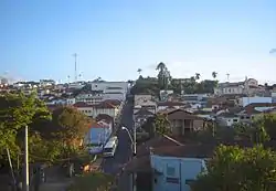
São Manuel
São Manuel is a municipality in the state of São Paulo in Brazil. The population is 41,123 (2020 est.) in an area of 651 km².[2] The elevation is 709 m.
São Manuel | |
|---|---|
 | |
 Flag  Coat of arms | |
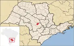 Location in São Paulo state | |
 São Manuel Location in Brazil | |
| Coordinates: 22°43′51″S 48°34′15″W | |
| Country | Brazil |
| Region | Southeast |
| State | São Paulo |
| Area | |
| • Total | 651 km2 (251 sq mi) |
| Population (2020 [1]) | |
| • Total | 41,123 |
| • Density | 63/km2 (160/sq mi) |
| Time zone | UTC-03:00 (BRT) |
| • Summer (DST) | UTC-02:00 (BRST) |
History
On April 19th, 1850, lieutenant Manoel Gomes de Faria, Dona Delfina Carolina Gomes, Antonio Joaquim Mendes, and Sinhorinha Rosa da Conceição, sponsored the foundation of Sao Manuel at Água Clara. On February 2, 1871, the location of the city was changed to Bairro do Paraízo, or the Tavares. The Chapel of St. Benedict was built and blessed in 1874. The date of foundation for the city is recorded as June 17, 1870.[3]
People from São Manuel
- Alice Sommerlath (1906-1997), mother of Queen Silvia of Sweden.
- Karina Bacchi (born in 1976), actress.
- Emilio Surita (born in 1961), humorist.
- Teresa Surita (born in 1956), politician.
References
- IBGE 2020
- "IBGE - Instituto Brasileiro de Geografia e Estatstica". cod.ibge.gov.br. Retrieved 2016-06-27.
- "History". Prefeitura Municipal de São Manuel - SP. Retrieved 2016-12-20.
This article is issued from Wikipedia. The text is licensed under Creative Commons - Attribution - Sharealike. Additional terms may apply for the media files.