Saint-Léger-Vauban
Saint-Léger-Vauban is a commune in the Yonne department in Bourgogne-Franche-Comté in north-central France.
Saint-Léger-Vauban | |
|---|---|
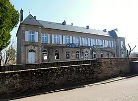 The town hall in Saint-Léger-Vauban | |
 Coat of arms | |
Location of Saint-Léger-Vauban 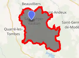
| |
 Saint-Léger-Vauban  Saint-Léger-Vauban | |
| Coordinates: 47°23′16″N 4°02′30″E | |
| Country | France |
| Region | Bourgogne-Franche-Comté |
| Department | Yonne |
| Arrondissement | Avallon |
| Canton | Avallon |
| Government | |
| • Mayor (2020–2026) | Damien Brizard |
| Area 1 | 33.81 km2 (13.05 sq mi) |
| Population (2017-01-01)[1] | 360 |
| • Density | 11/km2 (28/sq mi) |
| Time zone | UTC+01:00 (CET) |
| • Summer (DST) | UTC+02:00 (CEST) |
| INSEE/Postal code | 89349 /89630 |
| Elevation | 325–566 m (1,066–1,857 ft) (avg. 447 m or 1,467 ft) |
| 1 French Land Register data, which excludes lakes, ponds, glaciers > 1 km2 (0.386 sq mi or 247 acres) and river estuaries. | |
It lies within the Parc naturel régional du Morvan.
Geography
The town is situated between Rouvray and Quarré-les-Tombes. The nearest large town is Avallon.
History
The town was originally named Saint Leger, then Saint-Léger-de-Fourcheret until 1867, when Napoleon III issued an Imperial decree renaming it Saint-Léger-de-Vauban, after the French military engineer Vauban, who was born there in 1633.[2]
Sights
The church was restored in 1865 and has a functional bell tower. Saint-Léger-Vauban is also home to the Abbaye de la Pierre Qui Vire, and the Chateau de Rueres.
Economy
Saint-Léger's primary economic activity is farming, though there are several small shops, a post office, school, and multiple cheese makers.
References
- "Populations légales 2017". INSEE. Retrieved 6 January 2020.
- "Vauban 1633-1707". Histoire pour Tous (in French). Retrieved 5 January 2019.
External links
| Wikimedia Commons has media related to Saint-Léger-Vauban. |
- Official website (in French)
| Authority control |
|---|