Sainte-Vertu
Sainte-Vertu is a commune in the Yonne department in Bourgogne-Franche-Comté in north-central France.
Sainte-Vertu | |
|---|---|
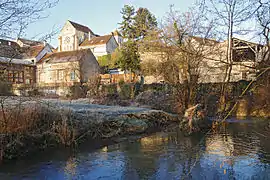 A general view of Sainte-Vertu | |
.svg.png.webp) Coat of arms | |
Location of Sainte-Vertu 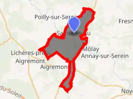
| |
 Sainte-Vertu  Sainte-Vertu | |
| Coordinates: 47°45′01″N 3°55′00″E | |
| Country | France |
| Region | Bourgogne-Franche-Comté |
| Department | Yonne |
| Arrondissement | Avallon |
| Canton | Chablis |
| Area 1 | 14.36 km2 (5.54 sq mi) |
| Population (2017-01-01)[1] | 90 |
| • Density | 6.3/km2 (16/sq mi) |
| Time zone | UTC+01:00 (CET) |
| • Summer (DST) | UTC+02:00 (CEST) |
| INSEE/Postal code | 89371 /89310 |
| Elevation | 150–271 m (492–889 ft) |
| 1 French Land Register data, which excludes lakes, ponds, glaciers > 1 km2 (0.386 sq mi or 247 acres) and river estuaries. | |
Geography
The surrounding communes are Môlay, Poilly-sur-Serein and Aigremont. Sainte-Vertu is situated 27 km (17 mi) to the south-east of Auxerre which is the nearest large town.
The village is traversed by the little Serein River. The Morvan natural park is approximately 29 km (18 mi) away.
Local Politics
In 2010 the mayor is Andre Oppendeau.
Demography
Recorded population peaked at 544 in 1821, but has fallen back steadily subsequently, the decline accelerating with the mechanisation of agriculture in the twentieth century. By 2005 the recorded population stood at just 104.
See also
References
- "Populations légales 2017". INSEE. Retrieved 6 January 2020.
External links
| Wikimedia Commons has media related to Sainte-Vertu. |
| Authority control |
|---|
This article is issued from Wikipedia. The text is licensed under Creative Commons - Attribution - Sharealike. Additional terms may apply for the media files.