Villeneuve-sur-Yonne
Villeneuve-sur-Yonne is a commune in the Yonne department in Bourgogne-Franche-Comté in north-central France.
Villeneuve-sur-Yonne | |
|---|---|
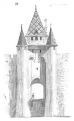 Sketch of the gate to the city by Eugène Viollet-le-Duc | |
 Coat of arms | |
Location of Villeneuve-sur-Yonne 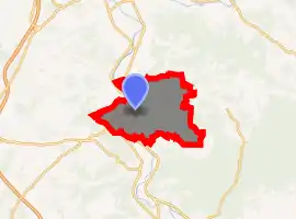
| |
 Villeneuve-sur-Yonne  Villeneuve-sur-Yonne | |
| Coordinates: 48°05′34″N 3°17′40″E | |
| Country | France |
| Region | Bourgogne-Franche-Comté |
| Department | Yonne |
| Arrondissement | Sens |
| Canton | Villeneuve-sur-Yonne |
| Government | |
| • Mayor (2020–2026) | Nadège Naze[1] |
| Area 1 | 40.00 km2 (15.44 sq mi) |
| Population (2017-01-01)[2] | 5,219 |
| • Density | 130/km2 (340/sq mi) |
| Time zone | UTC+01:00 (CET) |
| • Summer (DST) | UTC+02:00 (CEST) |
| INSEE/Postal code | 89464 /89500 |
| Elevation | 68–206 m (223–676 ft) |
| 1 French Land Register data, which excludes lakes, ponds, glaciers > 1 km2 (0.386 sq mi or 247 acres) and river estuaries. | |
It is surrounded by a partly intact wall, built during the 12th century, which was one of the 8 residences of the French kings.
History
The city was founded in 1163 by Louis VII of France to protect the kingdom of France at the boundary of the Champagne. In 1204 King Philip II Augustus held parliament in the city, and Louis IX resided in the city before departing for the Eighth Crusade. In 1594 the city was burnt down. During the French Revolution the name was changed from le-Roi (the king) to sur-Yonne (on the Yonne). In 1870 a memorial for the dead was designed by the sculptor Émile Peynot. The city was governed from 1927 till 1931 by the infamous mayor Marcel Pétiot, who was guillotined in 1946, convicted of 26 killings.
Demography
The inhabitants are called Villeneuviens.
| Year | 1936 | 1954 | 1962 | 1968 | 1975 | 1982 | 1990 | 1999 | 2006 | 2009 |
|---|---|---|---|---|---|---|---|---|---|---|
| Population | 4077 | 4372 | 4333 | 4452 | 4764 | 4980 | 5054 | 5404 | 5385 | 5263 |
Climate
| Climate data for Villeneuve-sur-Yonne | |||||||||||||
|---|---|---|---|---|---|---|---|---|---|---|---|---|---|
| Month | Jan | Feb | Mar | Apr | May | Jun | Jul | Aug | Sep | Oct | Nov | Dec | Year |
| Average high °C (°F) | 6 (43) |
8 (46) |
12 (54) |
15 (59) |
20 (68) |
23 (73) |
26 (79) |
26 (79) |
22 (72) |
16 (61) |
10 (50) |
7 (45) |
16 (61) |
| Average low °C (°F) | 1 (34) |
1 (34) |
4 (39) |
5 (41) |
9 (48) |
12 (54) |
14 (57) |
14 (57) |
11 (52) |
8 (46) |
4 (39) |
2 (36) |
7 (45) |
| Average rainfall cm (inches) | 3.78 (1.49) |
3.71 (1.46) |
2.96 (1.17) |
4.12 (1.62) |
4.32 (1.70) |
4.14 (1.63) |
4.12 (1.62) |
3.54 (1.39) |
4.1 (1.6) |
5.07 (2.00) |
4.81 (1.89) |
4.21 (1.66) |
48.88 (19.23) |
| Source: [3] | |||||||||||||
Main sights
- Two main entrance gates to the city, Gate of Sens and Gate of Joigny. The Gate of Joigny or Porte de Joigny was rebuilt in the 16th century; the Gate of Sens, or Porte de Sens, predates it by three hundred years and is similar in appearance.[4]
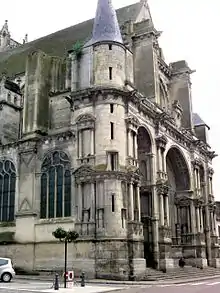
- Gothic and Renaissance Church Notre-Dame de l'Assomption (Our Lady of Assumption).
- City market built during the 19th century by Paul Sédille.
- La Lucarne aux Chouettes or The Owls' Nest restaurant which was run by Leslie Caron, serving Burgundy specialities. The old dilapidated boathouse was bought by her in 1990 on the suggestion of Jean Renoir.[5]
- A Neolithic menhir situated on the bank of the river, in the locality called Pierre-Fritte or Plaine-des-Egriselles.[6]
Sister and twin cities
See also
References
- "Répertoire national des élus: les maires". data.gouv.fr, Plateforme ouverte des données publiques françaises (in French). 2 December 2020. Retrieved 7 December 2020.
- "Populations légales 2017". INSEE. Retrieved 6 January 2020.
- "weather.uk.msn.com". Archived from the original on 2011-07-14. Retrieved 2007-02-26.
- "au-chateau.com". Archived from the original on 2007-03-20. Retrieved 2007-02-26.
- "Newsday.com". Retrieved 2007-02-26.
- Base Mérimée: Menhir, Ministère français de la Culture. (in French)
External links
| Wikimedia Commons has media related to Villeneuve-sur-Yonne. |