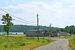
Seine River First Nation
Seine River First Nation, previously known as the Rivière la Seine Band, is an Ojibwe First Nation reserve located roughly 300 kilometres (190 mi) west of Thunder Bay, Ontario. As of November 2011, the First Nation had a total registered population of 725, of which 327 lived on their own reserve.
Seine River
Seine River Village Horse Collar Junction, Turtle Station | |
|---|---|
| Seine River First Nation | |
 | |
Seine River First Nations Logo | |
 Seine River | |
| Coordinates: 48.72398°N 92.42558°W | |
| Country | |
| Aboriginal People | |
| First Nation | Ojibawe |
| Tribe | Saulteaux |
| Band | Rainy Lake and Rainy River |
| Treaty 3 | 1873 |
| Grand Council | Grand Council of Treaty 3 |
| Tribal Council | Pwi-di-goo-zing Ne-yaa-zhing |
| Reserves[1] | Seine River 23A, Seine River 23B, Sturgeon Falls 23 |
| Government | |
| • Type | Act Electoral System |
| • Body | Band Council |
| • Chief | Carrie Lynn Boshkaykin |
| • Councilors | Carrie Lynn Boshkaykin Tammy Tania Boshkaykin Ronald Jay Friday Thomas Johnson John Kabatay Roger Brian Spencer Shane Curtis Whitecrow |
| • Federal Riding | Thunder Bay—Rainy River |
| • Provincial Riding | Kenora—Rainy River |
| Area | |
| • Total | 5,152.2 ha (12,731.4 acres) |
| • Populated Areas | 1,758.80 ha (4,346.09 acres) |
| Census Statistics suggest only one of three locations is considered populated. | |
| Elevation | 341 m (1,119 ft) |
| Population (2011)[5] | |
| • Total | 271 |
| • Density | 17.3/km2 (45/sq mi) |
| Data provided by Statistics Canada and the Ministry of Aboriginal Affairs and Northern Development conflict. | |
| Census Population (2006) | |
| • Status | 275 |
| • Non-status | 5 |
| Registered Status (2011) | |
| • On Reserve | 312 |
| • Off Reserve | 706 |
| Time zone | UTC-6 (CST) |
| • Summer (DST) | UTC-5 (CDT) |
| Postal Code | P0W 1H0 |
| Area code(s) | 807 |
| Geocode | 6956951 |
| CGNDB Key | FETBH |
| Band Number | 132 |
| Website | seineriverfirstnation |
Governance
The First Nation have an electoral system of government, consisting of a chief and seven councillors forming their council. Chief Carrie Lynn Boshkaykin and councillors Carrie Lynn Boshkaykin, Tammy Tania Boshkaykin, Ronald Jay Friday, Thomas Johnson, John Kabatay, Roger Brian Spencer and Shane Curtis Whitecrow are serving their two-year term that began on February 11, 2020.
The First Nation is a member of the Pwi-Di-Goo-Zing Ne-Yaa-Zhing Advisory Services, a regional Chiefs Council, which in turn is a member of the Grand Council of Treaty 3, a tribal political organization serving many of the First Nations in northwest Ontario and southeast Manitoba.
History
The original Mine Centre was a settlement associated with the gold rush around Shoal Lake with a population of 500. However, many residents moved to the new Mine Centre established by the Canadian Northern Railway after the collapse of the gold rush from 1903 to 1904.[8]
Seven Generations Education Institute (SGEI) is an Aboriginal-owned and controlled post-secondary institution co-founded by the ten bands in the Rainy Lake Tribal area in 1985. The ten bands are: Big Grassy, Big Island, Couchiching, Lac La Croix, Naicatchewenin, Nigigoonsiminikaaning, Ojibways of Onigaming, Rainy River, Seine River and Mitaanjigaming. Each of the ten bands appointed one member to a Board of Directors of Seven Generations Education Institute, which functions with the leadership of the Executive Director.
Reserve
The First Nation have reserved for itself three Indian Reserve tracts:[9]
- 1,758.8 hectares (4,346 acres) Seine River 23A (Ashkibwaanikaaning in the Ojibwe language), which serves as their main reserve.
- 904.5 hectares (2,235 acres) Seine River 23B (Mitaawangwe-ziibiing in the Ojibwe language)
- 2,488.9 hectares (6,150 acres) Sturgeon Falls 23 (Name-gojijiing in the Ojibwe language)
References
- "Seine River First Nation". Geography. Aboriginal Affairs and Northern Development Canada. Retrieved 2 November 2013.
- "Seine River First Nation". Governance. Aboriginal Affairs and Northern Development Canada. Retrieved 2 November 2013.
- "Seine River First Nation". Reserves/Settlements/Villages. Reserves/Settlements/Villages. Retrieved 2 November 2013.
- "About Seine River Indian Reserve 23A". Seine River Indian Reserve 23A. Mapcarta. Retrieved 2 November 2013.
- "Seine River 23A, IRI". Census Profile. Statistics Canada. Retrieved 2 November 2013.
- "Seine River First Nation". Population Census Statistics. Aboriginal Affairs and Northern Development Canada. Retrieved 2 November 2013.
- "Seine River First Nation". Connectivity Profile. Aboriginal Affairs and Northern Development Canada. Retrieved 2 November 2013.
- Barnes, Michael (1995). Gold in Ontario. Erin: The Boston Mills Press. pp. 22–23. ISBN 155046146X.
- "Aboriginal Peoples and Lands". GeoViewer. Government of Canada: Aboriginal Affairs and Northern Development Canada. Retrieved 24 October 2013.
External links
- INAC profile
- Official website
- Aboriginal Affairs and Northern Development Canada: First Nation Profiles
| Towns | 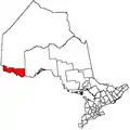 | |
|---|---|---|
| Townships | ||
| First Nations | ||
| Indian reserves |
| |
| Unorganized areas | ||
| Unincorporated communities | ||
| ||
| Numbered Treaties | |
|---|---|
| Anishinabeg of Kabapikotawangag Resource Council | |
| Bimose Tribal Council | |
| Pwi-Di-Goo-Zing Ne-Yaa-Zhing Advisory Services | |
| Other Treaty 3 Nations | |
| Authority control |
|---|