Unorganized Rainy River District
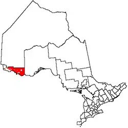
Unorganized Rainy River District is an unorganized area in the Rainy River District of Ontario, Canada, comprising all communities in the district which are not part of incorporated municipalities. Quetico Provincial Park is located entirely within this area.
Unorganized Rainy River District | |
|---|---|
| Rainy River, Unorganized | |
 Quetico sunset | |
 | |
| Coordinates: 48°45′N 92°30′W | |
| Country | |
| Province | |
| District | Rainy River |
| Government | |
| • Federal riding | Thunder Bay—Rainy River |
| • Prov. riding | Kenora—Rainy River Thunder Bay—Atikokan |
| Area | |
| • Land | 12,256.16 km2 (4,732.13 sq mi) |
| Population (2011)[1] | |
| • Total | 1,159 |
| • Density | 0.1/km2 (0.3/sq mi) |
| Time zone | UTC-6 (CST) |
| • Summer (DST) | UTC-5 (CDT) |
| Area code(s) | 807 |
The area has gradually been reduced in size as portions of it were annexed by surrounding incorporated townships. In 2004, the Township of Morley annexed the geographic townships of Sifton and Dewart, thereby splitting Unorganized Rainy River into two non-contiguous areas.[2]
The Township of Atikokan, as well as the Indian reserves of Rainy Lake 17A, 17B, 26A, Seine River 23A, and 23B, are enclaves within the unorganized area.
Communities include Arbor Vitae, Burditt Lake, Calm Lake, Flanders, Crilly, Gameland, Glenorchy, Government Landing, Kawene, Mine Centre, Off Lake Corner, Rocky Inlet and Sapawe.
Demographics
| Canada census – Rainy River, Unorganized community profile | |||
|---|---|---|---|
| 2011 | 2006 | ||
| Population: | 1159 (-19.0% from 2006) | 1431 (-6.2% from 2001) | |
| Land area: | 12,256.16 km2 (4,732.13 sq mi) | 12,247.18 km2 (4,728.66 sq mi) | |
| Population density: | 0.1/km2 (0.26/sq mi) | 0.1/km2 (0.26/sq mi) | |
| Median age: | 47.3 (M: 47.5, F: 47.0) | ||
| Total private dwellings: | 1523 | 1657 | |
| Median household income: | $58,888 | ||
| References: 2011[3] 2006[4] earlier[5] | |||
Population trend:[6]
- Population in 2011: 1159
- Population in 2006: 1431
- Population in 2001: 1605 (or 1526 when adjusted to 2006 boundaries)
- Population in 1996: 1580 (or 1614 when adjusted to 2001 boundaries)
- Land area: 14,198.07 square kilometres (5,481.91 sq mi)
- Population in 1991: 1495
See also
References
- "Rainy River, Unorganized census profile". 2011 Census of Population. Statistics Canada. Retrieved 2012-02-10.
- "The Full History". The Corporation of the Township of Morley. Retrieved 2011-05-04.
- "2011 Community Profiles". 2011 Canadian Census. Statistics Canada. July 5, 2013. Retrieved 2012-02-10.
- "2006 Community Profiles". 2006 Canadian Census. Statistics Canada. March 30, 2011. Retrieved 2011-05-17.
- "2001 Community Profiles". 2001 Canadian Census. Statistics Canada. February 17, 2012.
- Statistics Canada: 1996, 2001, 2006 census
Main eastern part | |
|---|---|
Western portion | ||||||||||
|---|---|---|---|---|---|---|---|---|---|---|
| ||||||||||
| Towns | 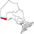 | |
|---|---|---|
| Townships | ||
| First Nations | ||
| Indian reserves |
| |
| Unorganized areas | ||
| Unincorporated communities | ||
| ||