Chapple, Ontario
Chapple (Canada 2016 Census population 638)[2] is a township municipality in Rainy River District in Northwestern Ontario, Canada.[1][4][5][6][7]
Chapple | |
|---|---|
| Township of Chapple | |
 The Rainy River in Barwick | |
| Etymology: Named after Thomas William Chapple | |
 Chapple Location in Ontario | |
| Coordinates: 48°44′33″N 93°59′41″W[1] | |
| Country | Canada |
| Province | Ontario |
| District | Rainy River |
| Incorporated | 1899 |
| Government | |
| • Reeve | Rilla Race |
| • Federal riding | Thunder Bay—Rainy River |
| • Provincial riding | Kenora—Rainy River |
| Area | |
| • Land | 527.94 km2 (203.84 sq mi) |
| Elevation | 335 m (1,099 ft) |
| Population (2016)[2] | |
| • Total | 638 |
| • Density | 1.2/km2 (3/sq mi) |
| Time zone | UTC-6 (Central Time Zone (CST)) |
| • Summer (DST) | UTC-5 (Central Time Zone (CDT)) |
| Postal code | P0W 1A0 |
| Area code(s) | 807 |
| Website | www |
Communities
Communities located in the township include:[5]
- Barwick
- Black Hawk - near Barwick Road and Highway 600
- Finland - Highway 71 near Korpi/Lampi Road
- Manders - on Highway 11 at the west of the township
- Shenston - Fehr Road and Tait Road
The township is served by Ontario Highway 71, a branch of the Trans-Canada Highway, and by Highway 600.
History
It was named after Thomas William Chapple, a former Ontario MPP from 1894 to 1898, who served as judge for the Rainy River District from 1898 to 1926. Before politics Chapple was a lawyer.
Demographics
| Canada census – Chapple (3559024) community profile | |||
|---|---|---|---|
| 2016 | 2011 | 2006 | |
| Population: | 638 (-13.9% from 2011) | 741 (-13.4% from 2006) | 856 (-5.9% from 2001) |
| Land area: | 527.94 km2 (203.84 sq mi) | 529.02 km2 (204.26 sq mi) | 529.02 km2 (204.26 sq mi) |
| Population density: | 1.2/km2 (3.1/sq mi) | 1.4/km2 (3.6/sq mi) | 1.6/km2 (4.1/sq mi) |
| Median age: | 39.8 (M: 40, F: 39.4) | 38.4 (M: 38, F: 38.8) | 35.7 (M: 35.7, F: 35.8) |
| Total private dwellings: | 225 | 376 | 345 |
| Median household income: | $39,593 | ||
| References: 2016[2] 2011[8] 2006[9] earlier[10] | |||
| Year | Pop. | ±% |
|---|---|---|
| 1991 | 948 | — |
| 1996 | 909 | −4.1% |
| 2001 | 910 | +0.1% |
| 2006 | 856 | −5.9% |
| 2011 | 741 | −13.4% |
| 2016 | 638 | −13.9% |
| [11][10][9][8][2] | ||
Climate
Barwick has a humid continental climate (Köppen Dfb).
| Climate data for Barwick (1981−2010) | |||||||||||||
|---|---|---|---|---|---|---|---|---|---|---|---|---|---|
| Month | Jan | Feb | Mar | Apr | May | Jun | Jul | Aug | Sep | Oct | Nov | Dec | Year |
| Record high °C (°F) | 9.0 (48.2) |
14.0 (57.2) |
19.5 (67.1) |
31.0 (87.8) |
34.0 (93.2) |
36.5 (97.7) |
35.5 (95.9) |
36.0 (96.8) |
34.0 (93.2) |
28.5 (83.3) |
21.0 (69.8) |
9.0 (48.2) |
36.5 (97.7) |
| Average high °C (°F) | −9.5 (14.9) |
−5.4 (22.3) |
1.3 (34.3) |
10.6 (51.1) |
18.0 (64.4) |
22.6 (72.7) |
25.2 (77.4) |
24.1 (75.4) |
18.3 (64.9) |
10.3 (50.5) |
0.5 (32.9) |
−7.0 (19.4) |
9.1 (48.4) |
| Daily mean °C (°F) | −15.3 (4.5) |
−11.6 (11.1) |
−4.4 (24.1) |
4.4 (39.9) |
11.4 (52.5) |
16.4 (61.5) |
19.0 (66.2) |
17.9 (64.2) |
12.6 (54.7) |
5.5 (41.9) |
−3.4 (25.9) |
−11.8 (10.8) |
3.4 (38.1) |
| Average low °C (°F) | −21.1 (−6.0) |
−17.8 (0.0) |
−10.1 (13.8) |
−1.8 (28.8) |
4.7 (40.5) |
10.1 (50.2) |
12.8 (55.0) |
11.7 (53.1) |
6.9 (44.4) |
0.8 (33.4) |
−7.3 (18.9) |
−16.7 (1.9) |
−2.3 (27.9) |
| Record low °C (°F) | −45.5 (−49.9) |
−49.0 (−56.2) |
−38.0 (−36.4) |
−25.0 (−13.0) |
−7.5 (18.5) |
−2.0 (28.4) |
2.5 (36.5) |
−1.0 (30.2) |
−5.5 (22.1) |
−17.0 (1.4) |
−39.0 (−38.2) |
−44.0 (−47.2) |
−49.0 (−56.2) |
| Average precipitation mm (inches) | 29.8 (1.17) |
21.3 (0.84) |
29.8 (1.17) |
39.2 (1.54) |
76.2 (3.00) |
124.7 (4.91) |
102.9 (4.05) |
78.8 (3.10) |
76.2 (3.00) |
58.8 (2.31) |
41.8 (1.65) |
30.7 (1.21) |
710.2 (27.96) |
| Average rainfall mm (inches) | 0.2 (0.01) |
3.0 (0.12) |
11.0 (0.43) |
30.4 (1.20) |
75.1 (2.96) |
124.7 (4.91) |
102.9 (4.05) |
78.8 (3.10) |
75.5 (2.97) |
51.3 (2.02) |
13.6 (0.54) |
2.1 (0.08) |
568.4 (22.38) |
| Average snowfall cm (inches) | 29.5 (11.6) |
18.3 (7.2) |
18.8 (7.4) |
8.9 (3.5) |
1.1 (0.4) |
0.0 (0.0) |
0.0 (0.0) |
0.0 (0.0) |
0.8 (0.3) |
7.5 (3.0) |
28.3 (11.1) |
28.6 (11.3) |
141.8 (55.8) |
| Average precipitation days (≥ 0.2 mm) | 13.7 | 10.7 | 11.3 | 9.4 | 12.5 | 13.4 | 12.2 | 11.4 | 12.9 | 12.7 | 12.4 | 14.8 | 147.5 |
| Average rainy days (≥ 0.2 mm) | 0.35 | 1.4 | 3.3 | 6.5 | 12.2 | 13.4 | 12.2 | 11.4 | 12.8 | 10.1 | 3.4 | 1.2 | 88.1 |
| Average snowy days (≥ 0.2 cm) | 13.5 | 10.0 | 9.0 | 3.7 | 0.81 | 0.0 | 0.0 | 0.0 | 0.31 | 3.7 | 10.0 | 14.2 | 65.2 |
| Source: Environment Canada[3] | |||||||||||||
Government
Township Council consists of a mayor and four councillors.[12]
Attractions
- Norlund Chapel - built from bell tower from St. Patrick's Church
- River View Park
- Pineview Conservative Mennonite Church
- Chapple Museum - formerly Gills Trading Post
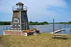
- Chapple Lighthouse - built 2003
- Barwick Waterfront
- Saint Paul's Heritage Church - former Anglican Church
See also
References
- "Chapple". Geographical Names Data Base. Natural Resources Canada. Retrieved 13 September 2018.
- "2016 Community Profiles". 2016 Canadian Census. Statistics Canada. 21 February 2017. Retrieved 13 September 2018.
- "Barwick, Ontario". Canadian Climate Normals 1981–2010. Environment Canada. Retrieved 12 February 2015.
- "Toporama (on-line map and search)". Atlas of Canada. Natural Resources Canada. Retrieved 13 September 2018.
- "Ontario Geonames GIS (on-line map and search)". Ontario Ministry of Natural Resources and Forestry. 2014. Retrieved 13 September 2018.
- Map 13 (PDF) (Map). 1 : 1,600,000. Official road map of Ontario. Ministry of Transportation of Ontario. 1 January 2016. Retrieved 13 September 2018.
- Restructured municipalities - Ontario map #1 (Map). Restructuring Maps of Ontario. Ontario Ministry of Municipal Affairs and Housing. 2006. Retrieved 13 September 2018.
- "2011 Community Profiles". 2011 Canadian Census. Statistics Canada. 5 July 2013. Retrieved 30 March 2012.
- "2006 Community Profiles". 2006 Canadian Census. Statistics Canada. 30 March 2011. Retrieved 4 May 2011.
- "2001 Community Profiles". 2001 Canadian Census. Statistics Canada. 17 February 2012.
- Statistics Canada: 2001 census
- "Council". Township of Chapple. Retrieved 13 September 2018.
External links
Places adjacent to Chapple, Ontario | |
|---|---|
| Towns | 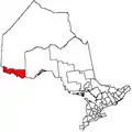 | |
|---|---|---|
| Townships | ||
| First Nations | ||
| Indian reserves |
| |
| Unorganized areas | ||
| Unincorporated communities | ||
| ||
This article is issued from Wikipedia. The text is licensed under Creative Commons - Attribution - Sharealike. Additional terms may apply for the media files.