Sheep River (Alberta)
The Sheep River is located in southwestern Alberta, Canada, and is part of the Bow River watershed. The river begins in the mountain valleys of Elbow-Sheep Wildland Provincial Park,[2] passes through Sheep River Provincial Park, and joins the Highwood River about 8 km east of Okotoks. The Sheep River provides drinking water for the towns of Turner Valley, Black Diamond, and Okotoks.
| Sheep River | |
|---|---|
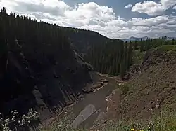 The gorge of the Sheep River west of Turner Valley | |
| Location | |
| Country | Canada |
| Province | Alberta |
| Physical characteristics | |
| Source | |
| • location | Elbow-Sheep Wildland Provincial Park |
| • coordinates | 50.67278°N 114.95736°W |
| • elevation | 2,100 meters (6,900 ft) |
| Mouth | |
• location | Highwood River |
• coordinates | 50.73998°N 113.85475°W |
• elevation | 983 meters (3,225 ft) |
| Discharge | |
| • average | 6 m3/s (210 cu ft/s) (at Black Diamond)[1] |
Tributaries
From origin to mouth, the Sheep River receives water from the following tributaries:
- Rae Creek (from Mount Rae)
- Burns Creek
- Cliff Creek
- Junction Creek
- Bluerock Creek
- Gorge Creek
- Dyson Creek
- March Creek
- Coal Creek
- Wolf Creek
- Long Prairie Creek
- Macabee Creek
- Waite Valley Creek
- Lineham Creek
- Turner Valley
- Threepoint Creek
- Spring Creek
- Wilson Coulee
See also
References
- Alberta Environment. Sheep River at Black Diamond Archived 2009-04-17 at the Wayback Machine
- Elbow-Sheep Wildland Provincial Park Archived 2006-05-03 at the Wayback Machine
External links
| Rivers | 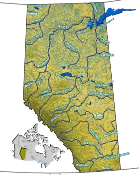 Rivers and lakes in Alberta | |
|---|---|---|
| Waterfalls | ||
| Lakes | ||
| Reservoirs | ||
| Glaciers | ||
| Other | ||
| Authority control |
|
|---|
This article is issued from Wikipedia. The text is licensed under Creative Commons - Attribution - Sharealike. Additional terms may apply for the media files.
