Shotton, Flintshire
Shotton is a town and community in Flintshire, Wales, within the Deeside conurbation along the River Dee, joined with Connah's Quay, near the border with England. It is located 5 miles (8 km) west of Chester and can be reached by road from the A548. In the 2011 census Shotton had a population of 6,663.[1][2] The Ordnance Survey Grid Reference is SJ305685.
| Shotton | |
|---|---|
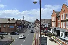 A view from the railway bridge, showing Chester Road | |
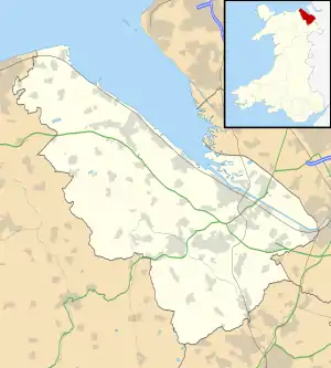 Shotton Location within Flintshire | |
| Population | 6,663 (2011 census) |
| OS grid reference | SJ305685 |
| Principal area | |
| Ceremonial county | |
| Country | Wales |
| Sovereign state | United Kingdom |
| Post town | DEESIDE |
| Postcode district | CH5 |
| Dialling code | 01244 |
| Police | North Wales |
| Fire | North Wales |
| Ambulance | Welsh |
| UK Parliament | |
| Senedd Cymru – Welsh Parliament | |
Etymology
The town's name is first recorded in Old English as Cyllingas deriving from a Celtic origin Cyllin or Cylla. This original name appears to have persisted throughout the town's history, serving today in the oldest part of the modern town as Killin's Farm and Killin's Lane. In 1822 Richard Willett recorded that the town contained one of the parish's most notable ancient houses, which by that time was named Kyllins. Willett also stated that this name derived from the Welsh language word Celyn (Holly).[3]
The town shares its modern English name with three other towns in Britain. These towns (all on the English side of the Scottish border) derive their names from Town of Scots but it is unlikely that a Flintshire town shares this etymology. The name probably derives from Scēot-tūn = "farmstead on or near a steep slope", or from Shot-tūn = "farmstead in a clearing in the wood". The town is officially named Shotton in both English and Welsh, making it one of the few towns in Wales to have neither a Welsh spelling or etymology.
History
Founded by Anglo-Saxons,[4] the town grew from the 18th century around coal mining and farming on reclaimed marshland. Shotton also became a railway junction. The John Summers & Sons steelworks was established in 1896 on a six acre site. At its peak it employed over 13,000. Following nationalisation in 1967, the works became part of the British Steel Corporation.[5] Although known as Shotton Steelworks, the majority of the large plant owned by Tata Steel since 2006, is in neighbouring Connah's Quay.
The town lies under the Hawarden Bridge, which was completed in 1889 as a swing-opening bridge.
Demography
Shotton has an area of 2.34km², with a density of 3,001km². The population is roughly 50% male and female and 62.2% are between the ages of 18-64.[1][2]
The community consists of three electoral wards of the Flintshire County Council local authority:
| Ward | 2001 census | 2011 census |
|---|---|---|
| Shotton East | 1,803[6] | 1,958[7] |
| Shotton Higher | 2,529[8] | 2,576[9] |
| Shotton West | 1,933[10] | 2,129[11] |
| Shotton Total | 6,265 | 6,663 |
Education
Shotton is served by the following schools:
- Connah's Quay High School
- Hawarden High School
- Taliesin Junior School, built 1972, an English medium school in the town. It is named after the 6th-century Welsh bard Taliesin. In 2003 it had 182 pupils.
- St Ethelwold's Primary School
- Ysgol Ty Ffynnon
- Venerable Edward Morgan Catholic
John Summers High School (formerly Deeside High School) closed on 20 July 2017.
Transport
Shotton railway station is on the Borderlands Line and the North Wales Coast Line.
See also
References
- UK Census (2011). "Local Area Report – Shotton Parish (Community) (W04000208)". Nomis. Office for National Statistics. Retrieved 29 January 2021.
- Brinkhoff, Thomas. "Shotton: Community in Wales". citypopulation.de. Retrieved 1 January 2021.
- Willet, Richard (1822). A Memoir of Hawarden Parish, Flintshire, Containing Short Introductory Notices of the Princes of North Wales: So Far as to Connect, and Elucidate, Distant and Obscure Events. Hawarden, Wales. p. 120.
- Atkinson, Keith. "Chapter 1: Shotton From Saxon Times". History of Shotton, Deeside. Retrieved 20 August 2009.
- Atkinson, Keith. "Chapter 11: John Summers & Sons". History of Shotton, Deeside. Retrieved 20 August 2009.
- UK Census (2001). "Local Area Report – Shotton East Ward (00NJRP)". Nomis. Office for National Statistics. Retrieved 29 January 2021.
- UK Census (2011). "Local Area Report – Holywell Central Ward (W05000231)". Nomis. Office for National Statistics. Retrieved 29 January 2021.
- UK Census (2001). "Local Area Report – Shotton Higher Ward (00NJRQ)". Nomis. Office for National Statistics. Retrieved 29 January 2021.
- UK Census (2011). "Local Area Report – Shotton Higher Ward (W05000232)". Nomis. Office for National Statistics. Retrieved 29 January 2021.
- UK Census (2001). "Local Area Report – Shotton West Ward (00NJRR)". Nomis. Office for National Statistics. Retrieved 29 January 2021.
- UK Census (2011). "Local Area Report – Shotton West Ward (W05000233)". Nomis. Office for National Statistics. Retrieved 29 January 2021.
External links
| Wikimedia Commons has media related to Shotton, Flintshire. |
| Authority control |
|---|