Grade II* listed buildings in Flintshire
In the United Kingdom, the term listed building refers to a building or other structure officially designated as being of special architectural, historical, or cultural significance; Grade II* structures are those considered to be "particularly important buildings of more than special interest".[1] Listing was begun by a provision in the Town and Country Planning Act 1947. Once listed, strict limitations are imposed on the modifications allowed to a building's structure or fittings. In Wales, the authority for listing under the Planning (Listed Buildings and Conservation Areas) Act 1990[2] rests with Cadw.
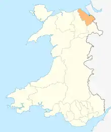
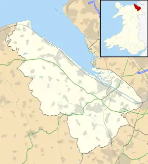
Flintshire shown within Wales
Buildings
| Name | Location | Date Listed | Grid Ref.[note 1] Geo-coordinates |
Function | Notes | Reference Number | Image |
|---|---|---|---|---|---|---|---|
| Bryn Iorcyn Manor | Llanfynydd | 14 February 1952 | SJ3004356936 53°06′18″N 3°02′47″W |
House | Situated c.1km NE of Cymau at the head of a drive running W from Bryn Yorkin Road.[3][4] | 6 |  |
| Trimley Hall | Llanfynydd | 14 February 1952 | SJ2775155836 53°05′41″N 3°04′49″W |
Farm building | Situated c1km NW of Ffrith, reached from a series of by-roads running W from the B5101.[5][6] | 8 | |
| St Deiniol's Parish Church | Hawarden | 7 February 1962 | SJ3154565918 53°11′09″N 3°01′33″W |
Church | Situated at the end of Church Lane within a walled churchyard.[7][8] | 12 | 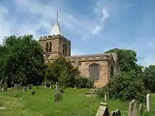 |
| The House of Correction | Hawarden | 7 February 1962 | SJ3174665719 53°11′03″N 3°01′22″W |
Lock-up | A mid-18th century lock-up traditionally ascribed to Joseph Turner.[9][10] Cross Tree Lane (E. side) | 21 | 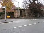 |
| Aston Hall | Hawarden | 7 February 1962 | SJ3091967029 53°11′45″N 3°02′08″W |
House | Situated off the road in its own walled grounds.[11][12] | 23 | |
| Plas-yn-Bwl | Caergwrle, Hope | 2 July 1962 | SJ3048357075 53°06′23″N 3°02′23″W |
House | Located at the southern edge of Caergwrle village on an elevated site above the A 541 (Wrexham Road); situated at the end of the lane partly behind low rubble forecourt walls.[13][14] | 29 | |
| Pack Horse Bridge | Caergwrle, Hope | 7 February 1962 | SJ3061557610 53°06′40″N 3°02′17″W |
Bridge | Spanning the River Alyn in the centre of Caergwrle village, at the end of Fellows Lane.[15][16] | 30 | 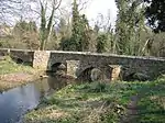 |
| The Brewhouse at Fferm Farmhouse | Leeswood | 7 February 1962 | SJ2791960325 53°08′07″N 3°04′44″W |
Brewhouse | Situated at the end of the driveway leading to Fferm Farmhouse, to the N side of the A541 and immediately adjacent to Fferm Farmhouse.[17][18] | 31 | |
| Rhydyn Hall | Hope | 2 July 1962 | SJ3113857086 53°06′23″N 3°01′48″W |
House | Overlooking the river Alyn to the E, on the line of Wat's Dyke, approximately 0.5km E of Caergwrle village centre; accessed via an unmetalled lane running S from the road.[19][20] | 34 | |
| Top-y-Fron Hall | Connah's Quay | 13 September 1977 | SJ2734469845 53°13′14″N 3°05′23″W |
House | Located off the E side of the lane at the top of the hill.[21][22] | 55 | |
| Church of St Mary | Gwaenysgor, Trelawnyd and Gwaenysgor | 11 June 1962 | SJ0751981028 53°19′05″N 3°23′23″W |
Church | In a walled churchyard in the centre of the village.[23][24] | 280 | 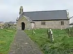 |
| Ty Isaf | Trelawnyd and Gwaenysgor | 11 June 1962 | SJ0758880933 53°19′02″N 3°23′19″W |
House | At the S end of the village, in a farmyard on the W side of a minor road between Trelawnyd and Gwaenysgor.[25] | 281 | |
| Leeswood Green Farm | Leeswood | 11 June 1962 | SJ2635460349 53°08′07″N 3°06′08″W |
Farmhouse | Situated at the end of a track off the main road, Oak Drive, which runs through Coedllai Leeswood.[26][27] | 286 | |
| Church of SS Asaph and Kentigern | Llanasa | 11 June 1962 | SJ1065181425 53°19′20″N 3°20′34″W |
Church | In the centre of Llanasa surrounded by a walled churchyard.[28][29] | 287 | 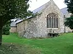 |
| Pentre Farmhouse | Llanasa | 11 June 1962 | SJ0953582863 53°20′06″N 3°21′36″W |
Farmhouse | Approximately 0.2km S of the Gronant village, reached by farm road from the centre of the village.[30][31] | 288 | |
| Church of St Michael | Caerwys | 11 June 1962 | SJ1273872860 53°14′44″N 3°18′33″W |
Church | At the centre of a large square churchyard on the SW side of the town, with the main entrance from Pen y Cefn Road.[32][33] | 291 | 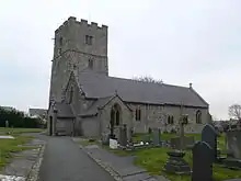 |
| Maes-y-coed Farmhouse | Caerwys | 11 June 1962 | SJ1299071490 53°14′00″N 3°18′18″W |
Farmhouse | Reached down a short farm road on the S side of the A541, just W of the junction of the A541 and B5122.[34] | 293 | |
| Brithdir Mawr | Cilcain | 11 June 1962 | SJ1784962937 53°09′26″N 3°13′48″W |
Hall House | Situated 2.5 km SW of Cilcain, reached from a minor road running W off the by road to Cilcain from Loggerheads.[35][36] | 298 | 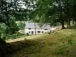 |
| Orchard Wall at Berthymaen Farm | Llanasa | 11 June 1962 | SJ1254180693 53°18′57″N 3°18′51″W |
Wall | On the SE side of the farmhouse and on the opposite side of the road.[37][38] | 300 | |
| Church of St Michael and All Angels | Nannerch | 11 June 1962 | SJ1667069676 53°13′03″N 3°14′58″W |
Church | At the northern end of the village set back from the road.[39][40] | 308 | 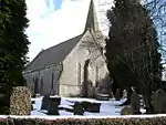 |
| Penbedw Uchaf, including attached garden wall | Nannerch | 11 June 1962 | SJ1551468712 53°12′32″N 3°15′59″W |
House | Approx. 1.5km SW of Nannerch village, reached by farm road on the S side of a minor road between Nannerch and Llandyrnog. The house faces S with farm buildings to the N, pond to the S and orchard to the W.[41][42] | 310 | |
| Walgoch | Nannerch | 11 June 1962 | SJ1618569149 53°12′46″N 3°15′24″W |
House | Approximately 0.7km SW of Nannerch village on the S side of a minor road between Nannerch and Llandyrnog.[43][44] | 311 | |
| St Mary's Parish Church | Nercwys | 11 June 1962 | SJ2347960421 53°08′08″N 3°08′43″W |
Church | Situated near the village cross-roads on a slight rise and set in its own churchyard.[45][46] Village Street (W Side), Nercwys | 312 | 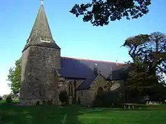 |
| Church of St Michael & All Angels | Trelawnyd, Trelawnyd and Gwaenysgor | 11 June 1962 | SJ0890679634 53°18′21″N 3°22′07″W |
Church | On the W side of the village and on the E side of a minor road S of London Road (A5151), the main road through the village.[47][48] | 316 | .jpg.webp) |
| Cross in churchyard of the Church of St Michael & All Angels | Trelawnyd, Trelawnyd and Gwaenysgor | 11 June 1962 | SJ0890979618 53°18′20″N 3°22′06″W |
Preaching cross | On the S side of the church.[49][50] | 317 |  |
| Northop Hall Farm (Llaneurgain) | Northop Hall | 11 June 1962 | SJ2680268436 53°12′29″N 3°05′51″W |
Farmhouse | To S of road, about 300m SE of crossroads with Smithy Lane.[51][52] | 323 | |
| Coed-y-cra Uchaf | Halkyn | 11 June 1962 | SJ2268270250 53°13′25″N 3°09′34″W |
On the NE side of the A55 and reached by minor road from the W side by a bridge across the main road.[53][54] | 326 | | |
| Plas Uchaf | Whitford | 6 November 1962 | SJ1390479243 53°18′11″N 3°17′36″W |
Set down and on the W side of the lane which runs N from Whitford to Tre Mostyn.[55][56] | 337 | | |
| Bryn Sion | Ysceifiog | 11 June 1962 | SJ1365571985 53°14′16″N 3°17′43″W |
Approx. 0.75km NE of Afonwen and reached by private road on the W side of a minor road between Afonwen and Babell.[57][58] | 347 | | |
| Pantgwynmawr | Ysceifiog | 11 June 1962 | SJ1551872233 53°14′25″N 3°16′02″W |
Approx. 0.8km NNE of Ysceifiog church, on the NE side at the end of a lane N of a minor road between Ysceifiog and Lixwm.[59][60] | 348 | | |
| Llwyn-erddyn | Ysceifiog | 11 June 1962 | SJ1760172636 53°14′40″N 3°14′10″W |
Approx. 1.8km NNE of Lixwm and reached by private road W of a minor road between Lixwm and Brynford.[61][62] | 350 | | |
| Drybridge Lodge | Mostyn | 12 October 1969 | SJ1508180078 53°18′39″N 3°16′34″W |
House | Built above a minor road between Rhewl Mostyn and Tre-Mostyn to the S of Mostyn Hall at the end of a long drive, now a footpath, from Pennsylvania Lodge in Whitford.[63][64] | 352 | .jpg.webp) |
| Bethesda Welsh Presbyterian Chapel and schoolroom | Mold | 29 June 1981 | SJ2367963780 53°09′56″N 3°08′35″W |
Chapel | Built 1863.[65][66] New Street | 391 | 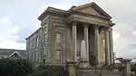 |
| Parish Church of St. James | Holywell | 26 July 1951 | SJ1853376276 53°16′38″N 3°13′24″W |
Church | Perpendicular church, 14th century, largely rebuilt 1769-70, chancel added 1884-5.[67][68] Greenfield Street | 428 | .jpg.webp) |
| Holywell Junction railway station | Holywell | 10 January 1970 | SJ1962277941 53°17′32″N 3°12′26″W |
Railway Station | Situated at the far end of the road on the SW side of the coastal railway.[69][70] | 510 | 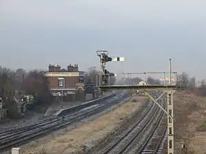 |
| Stokyn Hall | Greenfield, Holywell | 19 August 1991 | SJ1793678025 53°17′34″N 3°13′57″W |
Country house | Set in its own grounds, close to the NW boundary of the Community Council area.[71][72] | 512 | |
| Agricultural Range to S. Side of the Farmyard | Holway, Holywell | 24 February 1976 | SJ1730976214 53°16′35″N 3°14′30″W |
Originally a monastic grange to the Cistercian Abbey of Basingwerk.[73][74] Grange, Grange Lane, Holway | 514 | | |
| Hartsheath Hall | Leeswood | 4 October 1980 | SJ2863660246 53°08′05″N 3°04′05″W |
Hall | Situated in a fine nineteenth century landscape park to the N side of the A541 approximately 0.5 km to the E of Pontblyddyn.[75][76] | 537 | |
| Coach-house and Stables to NE of Hartsheath | Leeswood | 4 October 1980 | SJ2878560386 53°08′09″N 3°03′57″W |
Coach house and stables | Situated in the landscape park, at end of track to NE of Hartsheath Hall.[77][78] | 539 | |
| Soughton Hall | Sychdyn, Northop | 15 April 1985 | SJ2481967354 53°11′53″N 3°07′37″W |
Country House Hotel | Reached by the S driveway, a formal tree-lined avenue, and set in parkland.[79][80] | 547 | .jpg.webp) |
| Garden Walls, Corner Turrets, Gates and Gate Piers at Soughton Hall | Sychdyn, Northop | 15 April 1985 | SJ2483867314 53°11′51″N 3°07′36″W |
Walls,etc. | The walled gardens surround all 4 sides of Soughton Hall; the entrance gates are to the S.[81][82] | 548 | 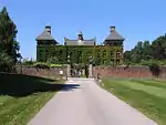 |
| Stable Block at Soughton Hall | Sychdyn, Northop | 15 April 1985 | SJ2480267261 53°11′50″N 3°07′38″W |
Stables | In a tree-lined enclosure to the SW of the house and facing N. The coach house range is attached at the NW corner.[83][84] | 549 | |
| Coach-house Range at Soughton Hall | Sychdyn, Northop | 15 April 1985 | SJ2478367268 53°11′50″N 3°07′39″W |
Coach house | In a tree-lined enclosure to the SW of the house and attached to the stable block at the SE corner. Tall rubble retaining wall to N, beyond which are formal gardens.[85][86] | 550 | |
| Talacre Abbey (Westbury Castle) | Talacre, Llanasa | 4 February 1987 | SJ1044083375 53°20′23″N 3°20′48″W |
Country House | In its own grounds E of Gronant village, on an elevated site overlooking the Dee Estuary to the N.[87][88] Now renamed Westbury Castle | 558 | 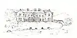 |
| Riding school & stable at Talacre Abbey | Talacre, Llanasa | 4 February 1987 | SJ1039083283 53°20′20″N 3°20′50″W |
Stables | To the SW of the house and set into the bank of the main approach road.[89][90] | 559 | |
| Banqueting House in Walled Garden at Talacre Abbey | Talacre, Llanasa | 4 February 1987 | SJ1013683300 53°20′20″N 3°21′04″W |
Banqueting house | Within the E wall of the walled garden W of the house.[91][92] | 560 | |
| Grotto adjoining Folly Tower at Talacre Abbey | Talacre, Llanasa | 4 February 1987 | SJ1051083330 53°20′21″N 3°20′44″W |
Grotto | In woodland on the SE side of the house, and S of the Folly Tower.[93][94] | 563 | |
| Home Farm at Talacre Abbey | Talacre, Llanasa | 4 February 1987 | SJ1019683145 53°20′15″N 3°21′01″W |
Farmhouse | On the N side of a track leading from the end of Abbey Drive in Gronant to Talacre Abbey, and approximately 350m SW of the house.[95][96] | 564 | |
| Leeswood Hall | Leeswood | 22 October 1952 | SJ2525661372 53°08′39″N 3°07′08″W |
Country house | Situated on the crest of hill close to the by-road from Mold to Leeswood village. Set in an exceptional early C18 landscape park.[97][98] | 567 | 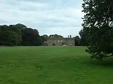 |
| Pair of Lodges flanking N driveway to Leeswood Hall | Leeswood | 22 October 1952 | SJ2544262029 53°09′01″N 3°06′59″W |
Lodges | Situated facing each other across wide forecourt, linked by late C20 iron work railings. Disused N driveway to Leeswood Hall runs from lodges across meadow to S.[99][100] | 573 | .jpg.webp) |
| Black Gates and Screens at Entrance to the Tower | Nercwys | 22 October 1952 | SJ2424762206 53°09′06″N 3°08′03″W |
Gates | Located on the W side of the main Mold-Nercwys road.[101][102] Formerly Listed together with Leeswood Hall | 574 | |
| Parkgate Farm Farmhouse and attached Shippon | Northop | 6 March 1991 | SJ2441668252 53°12′21″N 3°07′59″W |
Farmhouse | On the S edge of Northop and on a triangular site bound by roads. Reached by a narrow by-road which cuts off the NE angle of the triangle. The farmhouse faces E with shippon to N.[103][104] | 592 | |
| 2 Gelli Fawr | Whitford | 22 October 1952 | SJ1277978170 53°17′36″N 3°18′36″W |
Cottage | On the S side of a lane which runs NW from a roundabout on the A5151. The house, now divided, is set back from the road with long front gardens. To the rear, a boundary wall divides the rear gardens and joins a former stable. No 2 is to the R.[105][106] | 14877 | |
| Colomendy | Ysceifiog | 22 October 1952 | SJ1321069390 53°12′52″N 3°18′04″W |
House | Approximately 2km SSW of Ddol reached at the end of a minor road S of the A541.[107][108] | 14879 | |
| Gwysaney | Halkyn | 22 October 1952 | SJ2276666452 53°11′22″N 3°09′27″W |
House | In extensive grounds on the N side of Mold and reached by private drive on the N side of the A541.[109][110] | 14885 | .jpg.webp) |
| Berthymaen | Llanasa | 22 October 1952 | SJ1249480731 53°18′59″N 3°18′54″W |
House | On the W side of a minor road on the NE side of Trelogan.[111][112] | 14887 | |
| Maes-y-Groes Bella | Cilcain | 22 October 1952 | SJ1882563322 53°09′39″N 3°12′56″W |
House | Situated set back from the road 2.2 km SE of Cilcain, reached from the by road between Loggerheads and Cilcain.[113][114] | 14890 | |
| Barn at Nerquis Hall, Nerquis Hall Estate | Nercwys | 12 December 1994 | SJ2412460044 53°07′56″N 3°08′08″W |
Barn | Located at the E side of the service court.[115][116] | 15214 | |
| U-Shaped Agricultural Range to the W of Fron Hall | Gwernymynydd | 12 December 1994 | SJ2224062104 53°09′01″N 3°09′51″W |
Farm building | Located to the W of Fron Hall.[117][118] Swan Lane (W side), Fron Hall | 15257 | |
| Garden Walls and Pavilions at Rhual (including attached Walls and Gatepiers to the Drive Entrance), | Gwernaffield | 22 October 1952 | SJ2212164841 53°10′30″N 3°10′00″W |
Walls and Pavilions | Largely unaltered formal gardens thought to have been built by Evan Edwards post 1660.[119][120] | 16135 | |
| Church of St John | Rhydymwyn, Cilcain | 16 October 1995 | SJ2045866924 53°11′36″N 3°11′31″W |
Church | Situated in the churchyard close to the centre of the village.[121][122] Church Lane | 16440 | 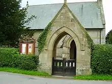 |
| Halkyn Castle and attached Stable Block | Halkyn | 26 November 1996 | SJ2094570916 53°13′46″N 3°11′09″W |
In extensive grounds approximately 300m S of Halkyn Church.[123][124] | 17792 | .jpeg.webp) | |
| St John the Baptist's Church | Penyffordd | 6 May 1997 | SJ3049962812 53°09′28″N 3°02′27″W |
Church | Situated in a churchyard on the N side of the A5104 at the N end of Penymynydd in an area also known as Pentrobin.[125][126] | 18470 | |
| St Matthew's Church | Buckley | 8 November 1997 | SJ2839664695 53°10′28″N 3°04′22″W |
Church | Situated in a churchyard off the E side of Church Road in the NE part of Buckley.[127][128] | 18755 | 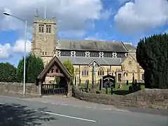 |
| Plymouth House and adjoining Coach House | Northop | 17 December 1997 | SJ2448968368 53°12′25″N 3°07′55″W |
House | Near the E end of the High Street, approx 70m from the junction with Northop Road. Set back from the street and facing N.[129][130] | 19185 | |
| Gazebo at Plas Teg | Hope | 5 June 1998 | SJ2873959718 53°07′48″N 3°03′59″W |
Gazebo | Immediately E of Plas Teg.[131][132] | 19762 | |
| Old Court | Caerwys | 22 October 1952 | SJ1280872949 53°14′47″N 3°18′29″W |
Fronting the road approximately 40m E of the junction with North and South Streets.[133][134] | 22774 | | |
| Grammar School | Northop | 22 October 1952 | SJ2466668518 53°12′30″N 3°07′46″W |
School | Located in the churchyard and forming part of the E boundary. The church is to the SW.[135][136] | 24440 | 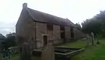 |
| Barn at Gellilyfdy | Ysceifiog | 22 October 1952 | SJ1463673887 53°15′18″N 3°16′52″W |
Barn | Approx. 100m SE of the farmhouse.[137][138] | 24676 | |
| The Roman Catholic Church of St David | Pantasaph, Whitford | 25 May 2001 | SJ1607175991 53°16′27″N 3°15′36″W |
Church | Adjoining the R side of Pantasaph Friary and in the grounds.[139][140] | 25240 | 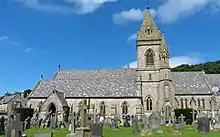 |
| Franciscan Friary | Pantasaph, Whitford | 25 May 2001 | SJ1606776019 53°16′28″N 3°15′36″W |
Friary | Set back from the road in grounds and approached by driveways. The Church of St David adjoins to the R. A linking range to the L joins the friary with the guest house and includes the entrance to the buildings.[141][142] | 25241 | .jpg.webp) |
| Guest House including linking range at Pantasaph Friary | Pantasaph, Whitford | 25 May 2001 | SJ1602476014 53°16′28″N 3°15′39″W |
Friary building | Set back from the road and approached by driveways. The linking range, which includes the main entrance, joins the guest house with the friary, which is to the R.[143][144] | 25242 | |
| 1 Gelli Fawr | Whitford | 22 October 1952 | SJ1278678166 53°17′36″N 3°18′36″W |
House | On the S side of a lane which runs NW from a roundabout on the A5151. The house, now divided, is set back from the road with long front gardens. To the rear, a boundary wall divides the rear gardens and joins a former stable. No 1 is to the L.[145][146] | 25259 | |
| Dovecote and adjoining range at Mostyn Hall | Mostyn | 28 March 2002 | SJ1476680645 53°18′57″N 3°16′51″W |
Dovecote | Forming the SE boundary of the farmyard and at right-angles to Porth Mawr.[147][148] | 26265 | |
| South-west Farm Building at Mostyn Hall Farm | Mostyn | 28 March 2002 | SJ1472680649 53°18′57″N 3°16′53″W |
Farm building | Along the SW side of the farmyard at Mostyn Hall, and at right-angles to the dovecote.[149][150] | 26267 | |
| North-east Barn at Mostyn Hall Farm with adjoining stable range and flanking wall | Mostyn | 28 March 2002 | SJ1475680683 53°18′58″N 3°16′52″W |
Barn | Forms the NE range of the large farmyard, and in staggered alignment with Porth Mawr, bounding the hall gardens on their SW side.[151][152] | 26269 | |
| North-west Range at Mostyn Hall Farm | Mostyn | 28 March 2002 | SJ1470380671 53°18′58″N 3°16′55″W |
Farm building | Forms the NW boundary of the main yard at Mostyn Farm.[153][154] | 26270 | |
| Church of St Mary | Broughton, Broughton and Bretton | 29 January 2003 | SJ3428364028 53°10′10″N 2°59′04″W |
Church | In the angle between Church Road and Chester Road (A5104), to the E of a large roundabout. Set in a large rectangular churchyard retaining some original boundary walling, the NW wall replaced when the road was widened.[155][156] | 80779 | 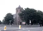 |
Notes
- Sometimes known as OSGB36, the grid reference is based on the British national grid reference system used by the Ordnance Survey.
References
- "Buildings & Conservation Areas". Cadw. Retrieved 18 June 2013.
- "Planning (Listed Buildings and Conservation Areas) Act 1990". The National Archives. Retrieved 18 June 2013.
- Cadw. "Bryn Iorcyn Manor (6)". National Historic Assets of Wales. Retrieved 9 April 2019.
- "Bryn Iorcyn Manor". British Listed Buildings. Retrieved 9 April 2019.
- Cadw. "Trimley Hall (8)". National Historic Assets of Wales. Retrieved 9 April 2019.
- "Trimley Hall". British Listed Buildings. Retrieved 9 April 2019.
- Cadw. "Parish Church of St Deinol (12)". National Historic Assets of Wales. Retrieved 9 April 2019.
- "Parish Church of St Deinol". British Listed Buildings. Retrieved 9 April 2019.
- Cadw. "The Correction House (21)". National Historic Assets of Wales. Retrieved 9 April 2019.
- "The Correction House". British Listed Buildings. Retrieved 9 April 2019.
- Cadw. "Aston Hall (23)". National Historic Assets of Wales. Retrieved 9 April 2019.
- "Aston Hall". British Listed Buildings. Retrieved 9 April 2019.
- Cadw. "Plas-yn-Bwl (29)". National Historic Assets of Wales. Retrieved 9 April 2019.
- "Plas-yn-Bwl". British Listed Buildings. Retrieved 9 April 2019.
- Cadw. "Pack Horse Bridge (30)". National Historic Assets of Wales. Retrieved 9 April 2019.
- "Pack Horse Bridge". British Listed Buildings. Retrieved 9 April 2019.
- Cadw. "The Brewhouse at Fferm Farmhouse (31)". National Historic Assets of Wales. Retrieved 9 April 2019.
- "The Brewhouse at Fferm Farmhouse". British Listed Buildings. Retrieved 9 April 2019.
- Cadw. "Rhydyn Hall (34)". National Historic Assets of Wales. Retrieved 9 April 2019.
- "Rhydyn Hall". British Listed Buildings. Retrieved 9 April 2019.
- Cadw. "Top y Fron Hall (55)". National Historic Assets of Wales. Retrieved 9 April 2019.
- "Top y Fron Hall". British Listed Buildings. Retrieved 9 April 2019.
- Cadw. "Church of St Mary (280)". National Historic Assets of Wales. Retrieved 9 April 2019.
- "Church of St Mary". British Listed Buildings. Retrieved 9 April 2019.
- Cadw. "Ty Isaf (281)". National Historic Assets of Wales. Retrieved 9 April 2019.
- Cadw. "Leeswood Green Farm (286)". National Historic Assets of Wales. Retrieved 9 April 2019.
- "Leeswood Green Farm". British Listed Buildings. Retrieved 9 April 2019.
- Cadw. "Church of SS Asaph and Kentigern (287)". National Historic Assets of Wales. Retrieved 9 April 2019.
- "Church of SS Asaph and Kentigern". British Listed Buildings. Retrieved 9 April 2019.
- Cadw. "Pentre Farmhouse (288)". National Historic Assets of Wales. Retrieved 9 April 2019.
- "Pentre Farmhouse". British Listed Buildings. Retrieved 9 April 2019.
- Cadw. "Church of St Michael (291)". National Historic Assets of Wales. Retrieved 9 April 2019.
- "Church of St Michael". British Listed Buildings. Retrieved 9 April 2019.
- Cadw. "Maes-y-coed Farmhouse (293)". National Historic Assets of Wales. Retrieved 9 April 2019.
- Cadw. "Brithdir Mawr (298)". National Historic Assets of Wales. Retrieved 9 April 2019.
- "Brithdir Mawr". British Listed Buildings. Retrieved 9 April 2019.
- Cadw. "Orchard Wall at Berthymaen Farm (300)". National Historic Assets of Wales. Retrieved 9 April 2019.
- "Orchard Wall at Berthymaen Farm". British Listed Buildings. Retrieved 9 April 2019.
- Cadw. "Church of St Michael and All Angels (308)". National Historic Assets of Wales. Retrieved 9 April 2019.
- "Church of St Michael and All Angels". British Listed Buildings. Retrieved 9 April 2019.
- Cadw. "Penbedw Uchaf, including attached garden wall (310)". National Historic Assets of Wales. Retrieved 9 April 2019.
- "Penbedw Uchaf, including attached garden wall". British Listed Buildings. Retrieved 9 April 2019.
- Cadw. "Walgoch (311)". National Historic Assets of Wales. Retrieved 9 April 2019.
- "Walgoch". British Listed Buildings. Retrieved 9 April 2019.
- Cadw. "St Mary's Parish Church (312)". National Historic Assets of Wales. Retrieved 9 April 2019.
- "St Mary's Parish Church". British Listed Buildings. Retrieved 9 April 2019.
- Cadw. "Church of St Michael & All Angels (316)". National Historic Assets of Wales. Retrieved 9 April 2019.
- "Church of St Michael & All Angels". British Listed Buildings. Retrieved 9 April 2019.
- Cadw. "Cross in churchyard of the Church of St Michael & All Angels (317)". National Historic Assets of Wales. Retrieved 9 April 2019.
- "Cross in churchyard of the Church of St Michael & All Angels". British Listed Buildings. Retrieved 9 April 2019.
- Cadw. "Northop Hall Farm (Llaneurgain) (323)". National Historic Assets of Wales. Retrieved 9 April 2019.
- "Northop Hall Farm (Llaneurgain)". British Listed Buildings. Retrieved 9 April 2019.
- Cadw. "Coed-y-cra Uchaf (326)". National Historic Assets of Wales. Retrieved 9 April 2019.
- "Coed-y-cra Uchaf". British Listed Buildings. Retrieved 9 April 2019.
- Cadw. "Plas Uchaf (337)". National Historic Assets of Wales. Retrieved 9 April 2019.
- "Plas Uchaf". British Listed Buildings. Retrieved 9 April 2019.
- Cadw. "Bryn Sion (347)". National Historic Assets of Wales. Retrieved 9 April 2019.
- "Bryn Sion". British Listed Buildings. Retrieved 9 April 2019.
- Cadw. "Pantgwynmawr (348)". National Historic Assets of Wales. Retrieved 9 April 2019.
- "Pantgwynmawr". British Listed Buildings. Retrieved 9 April 2019.
- Cadw. "Llwyn-erddyn (350)". National Historic Assets of Wales. Retrieved 9 April 2019.
- "Llwyn-erddyn". British Listed Buildings. Retrieved 9 April 2019.
- Cadw. "Drybridge Lodge (352)". National Historic Assets of Wales. Retrieved 9 April 2019.
- "Drybridge Lodge". British Listed Buildings. Retrieved 9 April 2019.
- Cadw. "Bethesda Welsh Presbyterian Chapel and Schoolroom (391)". National Historic Assets of Wales. Retrieved 9 April 2019.
- "Bethesda Welsh Presbyterian Chapel and Schoolroom". British Listed Buildings. Retrieved 9 April 2019.
- Cadw. "Parish Church of St. James (428)". National Historic Assets of Wales. Retrieved 9 April 2019.
- "Parish Church of St. James". British Listed Buildings. Retrieved 9 April 2019.
- Cadw. "Holywell Junction Railway Station (510)". National Historic Assets of Wales. Retrieved 9 April 2019.
- "Holywell Junction Railway Station". British Listed Buildings. Retrieved 9 April 2019.
- Cadw. "Stokyn Hall (512)". National Historic Assets of Wales. Retrieved 9 April 2019.
- "Stokyn Hall". British Listed Buildings. Retrieved 9 April 2019.
- Cadw. "Agricultural Range to south side of the Framyard at the Grange (514)". National Historic Assets of Wales. Retrieved 9 April 2019.
- "Agricultural Range to south side of the Framyard at the Grange". British Listed Buildings. Retrieved 9 April 2019.
- Cadw. "Hartsheath Hall (537)". National Historic Assets of Wales. Retrieved 9 April 2019.
- "Hartsheath Hall". British Listed Buildings. Retrieved 9 April 2019.
- Cadw. "Coach-house and Stables to NE of Hartsheath (539)". National Historic Assets of Wales. Retrieved 9 April 2019.
- "Coach-house and Stables to NE of Hartsheath". British Listed Buildings. Retrieved 9 April 2019.
- Cadw. "Soughton Hall (547)". National Historic Assets of Wales. Retrieved 9 April 2019.
- "Soughton Hall". British Listed Buildings. Retrieved 9 April 2019.
- Cadw. "Garden Walls, Corner Turrets, Gates and Gate Piers at Soughton Hall (548)". National Historic Assets of Wales. Retrieved 9 April 2019.
- "Garden Walls, Corner Turrets, Gates and Gate Piers at Soughton Hall". British Listed Buildings. Retrieved 9 April 2019.
- Cadw. "Stable Block at Soughton Hall (549)". National Historic Assets of Wales. Retrieved 9 April 2019.
- "Stable Block at Soughton Hall". British Listed Buildings. Retrieved 9 April 2019.
- Cadw. "Coach-house Range at Soughton Hall (550)". National Historic Assets of Wales. Retrieved 9 April 2019.
- "Coach-house Range at Soughton Hall". British Listed Buildings. Retrieved 9 April 2019.
- Cadw. "Talacre Abbey (558)". National Historic Assets of Wales. Retrieved 9 April 2019.
- "Talacre Abbey". British Listed Buildings. Retrieved 9 April 2019.
- Cadw. "Riding school & stable at Talacre Abbey (559)". National Historic Assets of Wales. Retrieved 9 April 2019.
- "Riding school & stable at Talacre Abbey". British Listed Buildings. Retrieved 9 April 2019.
- Cadw. "Banqueting House in Walled Garden at Talacre Abbey (560)". National Historic Assets of Wales. Retrieved 9 April 2019.
- "Banqueting House in Walled Garden at Talacre Abbey". British Listed Buildings. Retrieved 9 April 2019.
- Cadw. "Grotto adjoining Folly Tower at Talacre Abbey (563)". National Historic Assets of Wales. Retrieved 9 April 2019.
- "Grotto adjoining Folly Tower at Talacre Abbey". British Listed Buildings. Retrieved 9 April 2019.
- Cadw. "Home Farm at Talacre Abbey (564)". National Historic Assets of Wales. Retrieved 9 April 2019.
- "Home Farm at Talacre Abbey". British Listed Buildings. Retrieved 9 April 2019.
- Cadw. "Leeswood Hall (567)". National Historic Assets of Wales. Retrieved 9 April 2019.
- "Leeswood Hall". British Listed Buildings. Retrieved 9 April 2019.
- Cadw. "Pair of Lodges flanking N driveway to Leeswood Hall (573)". National Historic Assets of Wales. Retrieved 9 April 2019.
- "Pair of Lodges flanking N driveway to Leeswood Hall". British Listed Buildings. Retrieved 9 April 2019.
- Cadw. "Black Gates & Screens at Entrance to the Tower (574)". National Historic Assets of Wales. Retrieved 9 April 2019.
- "Black Gates & Screens at Entrance to the Tower". British Listed Buildings. Retrieved 9 April 2019.
- Cadw. "Parkgate Farm Farmhouse and attached Shippon (592)". National Historic Assets of Wales. Retrieved 9 April 2019.
- "Parkgate Farm Farmhouse and attached Shippon". British Listed Buildings. Retrieved 9 April 2019.
- Cadw. "2 Gelli Fawr (14877)". National Historic Assets of Wales. Retrieved 9 April 2019.
- "2 Gelli Fawr". British Listed Buildings. Retrieved 9 April 2019.
- Cadw. "Colomendy (14879)". National Historic Assets of Wales. Retrieved 9 April 2019.
- "Colomendy". British Listed Buildings. Retrieved 9 April 2019.
- Cadw. "Gwysaney (14885)". National Historic Assets of Wales. Retrieved 9 April 2019.
- "Gwysaney". British Listed Buildings. Retrieved 9 April 2019.
- Cadw. "Berthymaen (14887)". National Historic Assets of Wales. Retrieved 9 April 2019.
- "Berthymaen". British Listed Buildings. Retrieved 9 April 2019.
- Cadw. "Maes-y-Groes Bella (14890)". National Historic Assets of Wales. Retrieved 9 April 2019.
- "Maes-y-Groes Bella". British Listed Buildings. Retrieved 9 April 2019.
- Cadw. "Barn at Nequis Hall Estate (15214)". National Historic Assets of Wales. Retrieved 9 April 2019.
- "Barn at Nequis Hall Estate". British Listed Buildings. Retrieved 9 April 2019.
- Cadw. "U-Shaped Agricultural Range to the west of Fron Hall (15257)". National Historic Assets of Wales. Retrieved 9 April 2019.
- "U-Shaped Agricultural Range to the west of Fron Hall". British Listed Buildings. Retrieved 9 April 2019.
- Cadw. "Garden walls and pavillions at Rhual (including attached walls and Gatepiers to the drive entrance) (16135)". National Historic Assets of Wales. Retrieved 9 April 2019.
- "Garden walls and pavillions at Rhual (including attached walls and Gatepiers to the drive entrance)". British Listed Buildings. Retrieved 9 April 2019.
- Cadw. "Church of St John (16440)". National Historic Assets of Wales. Retrieved 9 April 2019.
- "Church of St John". British Listed Buildings. Retrieved 9 April 2019.
- Cadw. "Halkyn Castle and attached Stable Block (17792)". National Historic Assets of Wales. Retrieved 9 April 2019.
- "Halkyn Castle and attached Stable Block". British Listed Buildings. Retrieved 9 April 2019.
- Cadw. "St John the Baptist's Church (18470)". National Historic Assets of Wales. Retrieved 9 April 2019.
- "St John the Baptist's Church". British Listed Buildings. Retrieved 9 April 2019.
- Cadw. "St Matthew's Church (18755)". National Historic Assets of Wales. Retrieved 9 April 2019.
- "St Matthew's Church". British Listed Buildings. Retrieved 9 April 2019.
- Cadw. "Plymouth House and adjoining Coach-house (19185)". National Historic Assets of Wales. Retrieved 9 April 2019.
- "Plymouth House and adjoining Coach-house". British Listed Buildings. Retrieved 9 April 2019.
- Cadw. "Gazebo at Plas Teg (19762)". National Historic Assets of Wales. Retrieved 9 April 2019.
- "Gazebo at Plas Teg". British Listed Buildings. Retrieved 9 April 2019.
- Cadw. "Old Court (22774)". National Historic Assets of Wales. Retrieved 9 April 2019.
- "Old Court". British Listed Buildings. Retrieved 9 April 2019.
- Cadw. "Grammar School (24440)". National Historic Assets of Wales. Retrieved 9 April 2019.
- "Grammar School". British Listed Buildings. Retrieved 9 April 2019.
- Cadw. "Barn at Gellilyfdy (24676)". National Historic Assets of Wales. Retrieved 9 April 2019.
- "Barn at Gellilyfdy". British Listed Buildings. Retrieved 9 April 2019.
- Cadw. "The Roman Catholic Church of St David (25240)". National Historic Assets of Wales. Retrieved 9 April 2019.
- "The Roman Catholic Church of St David". British Listed Buildings. Retrieved 9 April 2019.
- Cadw. "Franciscan Friary (25241)". National Historic Assets of Wales. Retrieved 9 April 2019.
- "Franciscan Friary". British Listed Buildings. Retrieved 9 April 2019.
- Cadw. "Guest House including linking range at Pantasaph Friary (25242)". National Historic Assets of Wales. Retrieved 9 April 2019.
- "Guest House including linking range at Pantasaph Friary". British Listed Buildings. Retrieved 9 April 2019.
- Cadw. "1 Gelli Fawr (25259)". National Historic Assets of Wales. Retrieved 9 April 2019.
- "1 Gelli Fawr". British Listed Buildings. Retrieved 9 April 2019.
- Cadw. "Dovecote and adjoining range at Mostyn Hall (26265)". National Historic Assets of Wales. Retrieved 9 April 2019.
- "Dovecote and adjoining range at Mostyn Hall". British Listed Buildings. Retrieved 9 April 2019.
- Cadw. "South-west Farm Building at Mostyn Hall Farm (26267)". National Historic Assets of Wales. Retrieved 9 April 2019.
- "South-west Farm Building at Mostyn Hall Farm". British Listed Buildings. Retrieved 9 April 2019.
- Cadw. "North-east Barn at Mostyn Hall Farm with adjoining stable range and flanking wall (26269)". National Historic Assets of Wales. Retrieved 9 April 2019.
- "North-east Barn at Mostyn Hall Farm with adjoining stable range and flanking wall". British Listed Buildings. Retrieved 9 April 2019.
- Cadw. "North-west Range at Mostyn Hall Farm (26270)". National Historic Assets of Wales. Retrieved 9 April 2019.
- "North-west Range at Mostyn Hall Farm". British Listed Buildings. Retrieved 9 April 2019.
- Cadw. "Church of St Mary (80779)". National Historic Assets of Wales. Retrieved 9 April 2019.
- "Church of St Mary". British Listed Buildings. Retrieved 9 April 2019.
External links
![]() Media related to Grade II* listed buildings in Flintshire at Wikimedia Commons
Media related to Grade II* listed buildings in Flintshire at Wikimedia Commons
This article is issued from Wikipedia. The text is licensed under Creative Commons - Attribution - Sharealike. Additional terms may apply for the media files.