Sitarampur
Sitarampur is a neighbourhood in Asansol of Paschim Bardhaman district in the Indian state of West Bengal. It is governed by Asansol Municipal Corporation[1] It was one of the early hubs of coal mining activity. Coal was found in abundance around Sitarampur in the early years of the 19th century and mining started at this place in a big way.
Sitarampur | |
|---|---|
Neighbourhood in Asansol | |
 Sitarampur Location in Asansol, West Bengal, India | |
| Coordinates: 23.72°N 86.88°E | |
| Country | |
| State | West Bengal |
| District | Paschim Bardhaman |
| City | Asansol |
| Elevation | 100 m (300 ft) |
| Demonym(s) | Asansolians / Asansolites/ Asansolbashi |
| Languages* | |
| • Official | Bengali, Hindi, English |
| Time zone | UTC+5:30 (IST) |
| PIN | 713359 |
| Telephone code | 0341 |
| Lok Sabha constituency | Asansol |
| Vidhan Sabha constituency | Kulti |
| Website | paschimbardhaman |
Geography
| Cities, towns and ECL Areas in the western portion of Asansol Sadar subdivision in Paschim Bardhaman district MC: municipal corporation, P: rural administrative centre, CT: census town, N: neighbourhood, OG: out growth, T: temple Owing to space constraints in the small map, the actual locations in a larger map may vary slightly |
Location
Sitarampur is located at 23.72°N 86.88°E.[2] It has an average elevation of 100 m (330 ft).
Asansol is composed of undulating laterite soil. This area lies between two mighty rivers – the Damodar and the Ajay. They flow almost parallel to each other in the region – the average distance between the two rivers is around 30 km. For ages the area was heavily forested and infested with plunderers and marauders. The discovery of coal led to industrialisation of the area and most of the forests have been cleared.[3] At the western fringe of the area the Barakar forms the boundary with Jharkhand.
Urbanisation
As per the 2011 census, 83.33% of the population of Asansol Sadar subdivision was urban and 16.67% was rural.[4]Asansol Sadar subdivision has 26 (+1 partly) Census Towns.(partly presented in the map alongside; all places marked on the map are linked in the full-screen map).
Asansol Municipal Corporation
According to the Kolkata Gazette notification of 3 June 2015, the municipal areas of Kulti, Raniganj and Jamuria were included within the jurisdiction of Asansol Municipal Corporation.[5]
*For language details see Salanpur (community development block)#Language and religion
History
Coal mines
Coal in India was first discovered around Sitarampur. The early mines were Baro Dhemo and Sundarchak. Those mines are now defunct and they were closed about eighty years ago after being in operation for about seventy odd years. As those mines started to dry up, new virgin plots were excavated, some of which extended beyond the Damodar River into Purulia district and beyond River Barakar into the Nirsa of Dhanbad district in Jharkhand.
One of the deepest mines in Asia, Chinakuri 1 and 2, is located in this region. It is situated 1.2 miles (1.9 km) below the surface and inclines under the Damodar River extending for some 3.5 miles (5.6 km) into Purulia district. This mine boasts of a regular underground train service to ferry workers from the mine shaft to the coal face.
Mines safety
With hectic operations in the mines, accidents occurred frequently leading to loss of life. The government felt the need to regulate the mining process. Directorate of Mines Safety was set up for this purpose. It inspected the mining procedure with firm laws and imposed hard penalties for non-compliance. It resulted in a strong control on accidents and loss of life was reduced. Presently, the zonal office of the Directorate General of Mines Safety is located at Sitarampur.[6]
However, the mining community could not tackle the onslaught of nature, which came in the form of rain and floods. Mines were flooded and people got trapped inside. So a force was formed to help in rescue operations. The Mines Rescue Station was formed at Sitarampur and the mining community was taught what to do in such situations. Being an old mining area it was a pioneer in many fields. The ideas subsequently spread to other areas. Currently, six main rescue stations and eighteen rescue rooms with refresher training facilities have been established and are functioning in various subsidiaries of Coal India Limited.[7]
A small captive explosive manufacturing factory was established at Sitarampur for the supply of dynamite for solid blasting in open cast mines. The unit was in operation from around 1914 to 1935. The reason for the closure of this unit was the supply of dynamite to the revolutionaries who created hell for the ruling British. The authorities relocated the unit at various places far from the mining region and supply was strictly regulated.
Demographics
Economy
Coal
Sitarampur is mainly a coal-mining centre, hence many people in Sitarampur and Neamatpur work in the various Coal Mines of Eastern Coalfields Limited. Some People also work in the Office of the Directorate General of Mines Safety [DGMS] and in the Indian Railways. Most of the Marwaris in the town are involved in some Business or the other. Nearest police station is Neamatpur Investigation Centre.
Collieries in the Sitarampur Area of Eastern Coalfields are: Mithani, Bejdi, Dhemomain, Narsamuda, BC Incline and Patmohana.[8]
As per ECL website telephone numbers, operational collieries in the Sodepur Area in 2018 are: Bejdih Colliery, Chinakuri I & II Colliery, Chinakuri III Colliery, Dhemomain Incline Colliery, Dhemomain Pit Colliery, Dubeswary Colliery, Methani Colliery, Mouthdih Colliery, Narsamuda Colliery, Parbelia Colliery, Patmohana Colliery and Sodepur Colliery. This website does not show Sitarampur as a separate Area.[9]
Educational institutions
The Belrui N.G. Institution(HS)(1926), N.D.Rashtriya Vidyalaya(HS) and Jaladhi Kumari Devi Uchcha Balika Vidyalaya(HS) are the three most renowned government schools in and around Sitarampur. These three schools have produced many board exam Toppers in the Asansol subdivision. The Nearest English Medium Schools are Priyadarshini Public School and Green Point Academy are situated in Kulti . St. Patricks High School, St. Vincents School,and Loreto Convent in Asansol and The Assembly of God Church School at Sodepur. Higher Education facilities like Colleges are available nearby here. Kulti college is one of them.
In this connection Tagore Institute of Sitarampur deserves special mention, as it marks a landmark of the place, although it now stands in a desolate and dilapidated condition in the western end of the Railway playground. The Tagore Institute was in the past a hub of cultural activities, and dramatic performances and cinema shows used to be staged on festival seasons. Seasonal games of football and cricket were played in the playground on regular basis. By the psychological law of association the name of Akhil Memorial Challenge Shield (Now defunct) comes to mind. Durgapuja is held here on a permanent structure erected close to Tagore Institute, for continuous 74th year There is another playground nearby called "Paltandanga" near Neamatpur where circus and sporting activities like cycle race used to be held during winter months. Incidentally, during the Second World War large platoons of American and British soldiers used to set up tents for sojourn in "Paltandanga", hence the name of the ground, in Bengali 'paltan' being the corrupt and distorted form of English word 'platoon'.
During the great war Belrui school was used as a temporary storehouse of foodgrains for buffer stock, and classes remained suspended for a pretty long time. Then there is Railway Vidyapith (Primary School) founded in 1954 close to the Rly health centre, which has been subsequently upgraded up to class VIII. As a result of steady expansion of population and urban agglomarization new colony has come up in the area which was previously known as loco colony towards Asansol. Ramkrishna mission school is very renowned school in Asansol. Now Asansol has an engineering college, which also runs certificate courses. This college is located on the national highway(NH-19). Kanyapur Polytechnic, Asansol ITI are also there.
Transport
Railways in Asansol | |||||||||||||||||||||||||||||||||||||||||||||||||||||||||||||||||||||||||||||||||||||||||||||||||||||||||||||||||||||||||||||||||||||||||||||||||||
|---|---|---|---|---|---|---|---|---|---|---|---|---|---|---|---|---|---|---|---|---|---|---|---|---|---|---|---|---|---|---|---|---|---|---|---|---|---|---|---|---|---|---|---|---|---|---|---|---|---|---|---|---|---|---|---|---|---|---|---|---|---|---|---|---|---|---|---|---|---|---|---|---|---|---|---|---|---|---|---|---|---|---|---|---|---|---|---|---|---|---|---|---|---|---|---|---|---|---|---|---|---|---|---|---|---|---|---|---|---|---|---|---|---|---|---|---|---|---|---|---|---|---|---|---|---|---|---|---|---|---|---|---|---|---|---|---|---|---|---|---|---|---|---|---|---|---|---|
| |||||||||||||||||||||||||||||||||||||||||||||||||||||||||||||||||||||||||||||||||||||||||||||||||||||||||||||||||||||||||||||||||||||||||||||||||||
| Sources:[10][11] | |||||||||||||||||||||||||||||||||||||||||||||||||||||||||||||||||||||||||||||||||||||||||||||||||||||||||||||||||||||||||||||||||||||||||||||||||||
As movement of coal by trains increased considerably a new railway line, the Grand Chord, was laid from Sitarampur to Mughalsarai. At that time, Sitarampur railway station boasted of the largest steam locomotive shed and the second largest coal moving yard in the country. Now the steam loco shed is gone as steam engines were phased out.
The Howrah-Delhi rail track separates into the Main and Grand Chord lines at Sitarampur and rejoins at Mughalsarai. Hence many important trains on the Howrah - Delhi passes through and have stoppages at Sitarampur.
Some major trains providing stoppage at Sitarampur are Dhanbad - Howrah Coalfield Express and Black Diamond Express, Kathgodum Express, Mithila Express etc. Many local and passenger trains connect Sitarampur with Dhanbad, Gomoh, Chittaranjan, Asansol and Bardhaman and to Madhupur and Deoghar in Deoghar district of Jharkhand and various other parts of Jharkhand and Bihar.
Road connectivity to Sitarampur is provided through the Grand Trunk Road which passes through the adjacent town of Neamatpur. One can go to Kolkata, Durgapur, Barakar and Dhanbad easily travelling by the Grand Trunk Road. One can also go to Purulia via Dishergarh and to Chittaranjan after reaching the Grand Trunk Road at Neamatpur.
Regular Minibus services are available from Asansol City Bus Terminus, Barakar, Chittaranjan and Dishergarh. All the mini buses provide a stoppage at Neamatpur. Some Express and Long Distance Government Buses also provide a stoppage at Neamatpur.
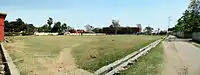 The Field of Sitarampur
 Tagore Institute, Sitarampur
 The Loop, Sitarampur
 Forest Flame Trees in Sitarampur
 The Loco Tank and Bokababa Temple of Sitarampur
References
- https://www.wbdma.gov.in/circulars/249-135-ma_2015-2016.pdf
- Falling Rain Genomics, Inc - Sitarampur
- Chattopadhyay, Akkori, Bardhaman Jelar Itihas O Lok Sanskriti (History and Folk lore of Bardhaman District.), (in Bengali), Vol I, pp 14-15, Radical Impression. ISBN 81-85459-36-3
- "District Statistical Handbook 2014 Burdwan". Table 2.2, 2.4(a). Department of Statistics and Programme Implementation, Government of West Bengal. Retrieved 4 September 2018.
- "The Kolkata Gazette" (PDF). Notification No. 335/MA/O/C-4/1M-36/2014 dated 3 June 2015. Department of Municipal Affairs, Government of West Bengal. Retrieved 9 March 2017.
- Director General of Mines Safety
- PIB Press Release
- "Coalmining impact on the Environment" (PDF). Chapter V: Table 5.2. shodganga.infibnet. Retrieved 21 February 2017.
- "Area wise Closed User Group (CUG) Telephone Numbers" (PDF). Sripur Area. Eastern Coalfields Limited. Retrieved 11 August 2018.
- "Asansol Division Railway Map". Eastern Railway.
- "Adra Division Railway Map". South Eastern Railway.
Cities, towns and locations in Paschim Bardhaman district, West Bengal | |||||
|---|---|---|---|---|---|
| Cities, municipal and census towns | |||||
| Locations other than cities and towns |
| ||||
| Neighbourhoods in Asansol |
| ||||
| Related topics |
| ||||