Deoghar
Deoghar (pronounced Devaghar) is a major city in Jharkhand, India. It is a holy sacred place of Hinduism. It is one of the 12 Jyotirlingas sites of Hinduism (Baidyanath Temple). The sacred temples of the city make this a place for pilgrimage and tourists. Also, the city has archaeological and historical value. Ancient Indian books and scripts state the age of the city is Vedic or before Vedic period.{{Citation needed}} In the current context, the city is administrative headquarter of Deoghar District at Santhal Parganas division of Jharkhand.
Deoghar Devaghar | |
|---|---|
.jpg.webp) 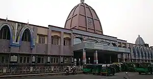  .jpg.webp) 1. Prayer in the Satsang Ashram; 2. Deoghar railway station; 3. Sacred pond at the Baidyanath Dham Temple; 4. the Naulakkha Temple | |
 Deoghar Devaghar  Deoghar Devaghar | |
| Coordinates: 24.48°N 86.7°E | |
| Country | India |
| State | Jharkhand |
| District | Deoghar |
| Government | |
| • Body | Deoghar Municipal Corporation |
| Area | |
| • Total | 119 km2 (46 sq mi) |
| Elevation | 254 m (833 ft) |
| Population (2011)[1] | |
| • Total | 203,123 |
| Languages (*For language details see Deoghar (community development block)#Language and religion) | |
| • Official | Hindi, Urdu |
| Time zone | UTC+5:30 (IST) |
| PIN | 814112 |
| Telephone code | 06432 |
| Vehicle registration | JH-15 |
| Sex ratio | 921 ♂/♀ |
| Lok Sabha constituency | Godda |
| Vidhan Sabha constituency | Deoghar |
| Website | deoghar |
The city has responsible judiciary, administrative and political systems. In the state of Jharkhand, it has rich natural and forest reserves.{{cn}} The current development of the city tries to open some landmark education institutes, hospital, airport and hubs.{{Citation needed}} It is the administrative headquarters of Deoghar District.
Etymology
Deoghar is a Hindi word and the literal meaning of ‘Deoghar’ is abode (‘ghar’) of the Gods and Goddesses (‘dev’). Deoghar is also known as “Baidyanath Dham”, “Baba Dham”, “B. Deoghar”. The origin of Baidyanathdham is lost in antiquity. It has been referred to as Haritakivan or Ketakivan in Sanskrit Texts. The name Deoghar seems to be of recent origin and probably dates from the erection of the great temple of Lord Baidyanath. Although the name of the builder of the temple is not traceable, certain parts of the front portion of the temple are said to have been built by Puran Mal, an ancestor of the Maharaja of Giddhour, in 1596. Deoghar is a place of worship for Lord Shiva, in the month of Shravan many devotees takes ganga jal from Sultanganj to Deoghar for worship and they get the desired wish of their life.[2]
Religious significance
Deoghar, also known as Baidyanath Dham, is an important Hindu pilgrimage site. It is one of the twelve and also one of the 51, and is famous for the mela of Shrawan, 4th month according to the Hindu calendar system. It is, along with Shrisailam, one of the few places in India where the Jyotirlinga and the Shaktipeeth are together, lying side beside each other. Each year between July and August (on the eve of the month of Shrawan) in Deoghar Yatra, about 7 to 8 million devotees come from various part of India bringing holy water from various areas of Ganges at Sultanganj, which is almost 108 km (67 mi) from Deoghar, in order to offer it to Lord Shiva. During that month, a line of people in saffron-dyed clothes stretches over the full 108 km (67 mi). It is the longest Mela of Asia.[2]
The temple of Baidyanath or Lord Shiva is the most important of all the temples in the courtyard. The temple faces the east and is a plain stone structure with a pyramidal tower, 72 feet tall. The top contains three ascending shaped gold vessels that are compactly set, and were donated by the Maharaja of Giddhaur. Besides these pitcher shaped vessels, there is a Punchsula (five knives in a trident shape), which is rare. In the inner top, there is an eight-petaled lotus jewel called Chandrakanta Mani.
Geography
Location
Deoghar is located at 24.48°N 86.7°E.[3] It has an average elevation of 255 metres (833 feet). It is a part of the Indian peninsular plateau which forms a part of the oldest landmass on Earth, Gondwana land.[4] Deoghar is situated on the bank of Ajay river (which originates from Batpar village of Jamui district in Bihar) and its tributary Dadhawa river( which originates from Purnia Lake near Karangarh village 24.595501°N 86.474369°E in Jamui district of Bihar). The city is surrounded with various small relict hills such as Dighriya Pahaad, Nandan Pahaad, Trikuti Pahaad, and Tapovan Pahaad. Dighriya Pahaad forms the western boundary of the city and there is a national park being constructed on these hills.{{Citation needed}} Nandan Pahaad is a children's amusement place and serves as one the principal recreational place in the city.[5] Tapovan Pahaad has its cultural relevance found in Hindu scriptures. It is one of the amusement places in the city and serves as a habitat for monkeys.[6]
Overview
The map shows a large area, which is a plateau with low hills, except in the eastern portion where the Rajmahal hills intrude into this area and the Ramgarh hills are there. The south-western portion is just a rolling upland. The entire area is overwhelmingly rural with only small pockets of urbanisation.[7]
Note: The full screen map is interesting. All places marked on the map are linked in the full screen map and one can easily move on to another page of his/her choice. Enlarge the full screen map to see what else is there – one gets railway connections, many more road connections and so on.
Demographics
| Cities, Towns and Locations in the Deoghar, Dumka and Jamtara Districts in Santhal Pargana Division M: Municipality, CT: census town, R: Rural/ Urban centre, D: Dam, |
According to the 2011 Census of India, Deoghar had a total population of 203,123,[1] of which 107,997 (53%) were males and 95,126 (47%) were females. Population in the age range 0–6 years was 2,6893 (13%). The total number of literate persons in Deoghar was 176,230 (85.68% of the population over 6 years).[8]
As of 2001 India census, Deoghar had a population of 98,372. Males constitute 55% of the population and females 45%. Deoghar has an average literacy rate of 76%, higher than the national average of 59.5%: male literacy is 82% and, female literacy is 69%. In Deoghar, 12% of the population is under 6 years of age.[9]
Economy
The Economy of Deoghar is largely dependent on religious tourism and hospitality. Deoghar is the fifth largest city in the state of Jharkhand, and one of the major industrial hubs. [10][11]
Industry in Deoghar is mainly based on IT, agriculture, hospitality, petroleum, tourism, and in the service sector. Hotels like Amrapali Clarks Inn (a collab of Amrapali Groups & Clarks Inn Group of Hotels), Hotel Imperial Heights, etc. are renowned groups of hospitality industry here. Various small and middle scale industries are present in Deoghar - HIL Ltd,[12] MR Real Food, Shree Guru Agrotech, PDRD Rice Mill, Tulsi Agro Foods. Some large industrial projects are also present:
- Jalsar Solar Park: Established by Jharkhand Renewable Energy Development Agency
- Plastic Park and Plastic Recycling unit
- Central Institute of Plastics Engineering & Technology[13]
Indian Oil Corporation has one of its terminals in Deoghar. This is located at Badladih, Jasidih. This has a huge capacity for employment. After the opening and coming of this terminal, the unemployment rate has decreased because of many people getting jobs from this company.
Software Technology Parks of India (STPI) is a company / organization which promotes IT and technology industries. This company has setup many IT park branches in many cities such as Bangalore, Hyderabad, Patna and Ranchi etc. Same as the others, it has setup another IT Park branch in Deoghar. It is almost completed and opened.
Culture
Deoghar city is usually referred to as the cultural capital of Jharkhand.[14] The official language of the city of Deoghar is Hindi and Urdu. The native languages of Deoghar are Hindi, Angika, Hindi and Santhali.
 Part of the interior of a Hindu Temple, at Deo, in Bahar, from Rees's Cyclopedia, 1802
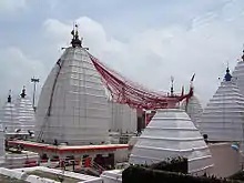 Baidyanath Dham
.jpg.webp) Naulakkha temple
Naulakkha temple
Education
- All India Institute of Medical Sciences - Deoghar
- Deoghar College - affiliated under S.K.M University
- A.S.College
- Birla Institute of Technology - Deoghar (Ranchi Offcampus)
- Baidyanath Kamal Kumari Sanskrit College
- Dev Sangha Institute of Professional Studies and Educational Research (DIPSER)[15]
- Deoghar Industrial Training Centre
Transportation
Airport
Deoghar Airport is being constructed since 2018.[16] Services have not started as of 2020.[17]
Trains
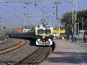
Jasidih Junction is the nearest train station serving Deoghar. It is located on the Delhi-Patna-Kolkata train route.
References
- "Deoghar City".
- {Url=http://deoghar.nic.in/history}
- "Maps, Weather, and Airports for Deoghar, India". www.fallingrain.com.
- https://www.explorebihar.in/tapovan-deoghar.html
- Roychoudhury, P.C. "Bihar District Gazetteers: Santhal Parganas". Chapter I: General. Secretariat Press, Patna, 1965. Retrieved 10 November 2020.
- "District Census Handbook, Deoghar, Series 21, Part XII B" (PDF). Page 25: District Primary Census Abstract, 2011 census. Directorate of Census Operations Jharkhand. Retrieved 3 November 2020.
- "Census of India 2001: Data from the 2001 Census, including cities, villages and towns (Provisional)". Census Commission of India. Archived from the original on 16 June 2004. Retrieved 1 November 2008.
- "Deoghar, the holy city in Jharkhand all set to have a new airport, flight operations to start soon". www.timesnownews.com. Retrieved 4 December 2020.
- "Good news for Baidyanath Dham pilgrims! Jharkhand govt allows darshans — check details". The Financial Express. 26 August 2020. Retrieved 4 December 2020.
- Limited, H. I. L. "Roofing Solutions, Building and Cladding Material Manufacturer". Roofing Solutions, Building and Cladding Material Manufacturer. Retrieved 5 January 2020.
- "Centre Sanctions Rs 120 Crore for Plastic Park in Jharkhand; Promises CIPET Centre". News18. Retrieved 5 January 2020.
- {Url=http://www.uniindia.com/news/others/deoghar-to-get-status-of-cultural-capital-of-jharkhand/11368.html}
- "Dipser College". www.dipsercollege.info. Retrieved 5 January 2020.
- "Jharkhand Renames Several Institutes After Atal Bihari Vajpayee". NDTV.com. Retrieved 5 January 2020.
- "Darbhanga airport takes off, Deoghar lags behind". telegraphindia.com. Retrieved 26 January 2021.
External links
| Wikimedia Commons has media related to Deoghar. |
 Deoghar travel guide from Wikivoyage
