Slieve Muck
Slieve Muck (/sliːv mʌk/ SLEEV MUK; from Irish: Sliabh Muc, meaning "pig mountain") is one of the Mourne Mountains in County Down, Northern Ireland.[2] It has a height of 670.4 metres (2,199 ft). The River Bann has its source on the northern slope.[3][4]
| Slieve Muck | |
|---|---|
| Sliabh Muc | |
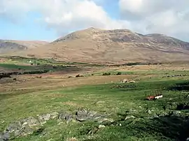 The southern slopes of Slieve Muck | |
| Highest point | |
| Elevation | 670.4 m (2,199 ft) [1] |
| Prominence | 156 m (512 ft) [1] |
| Listing | Marilyn, Hewitt |
| Coordinates | 54°09′29″N 6°02′23″W |
| Geography | |
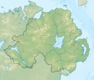 Slieve Muck within Northern Ireland | |
| Location | County Down, Northern Ireland |
| Parent range | Mourne Mountains |
| OSI/OSNI grid | J282250 |
| Topo map | OSNI Landranger 29, OSNI Outdoor Pursuits map Mourne Country |
Slieve Muck has three summits which are composed of Silurian shale covering the underlying granite. The shale forms an escarpment near the eastern side of the summits. The western slope is grassy and has a number of small streams flowing into the Deer's Meadow below. The eastern slope below the escarpment is made up of stony scree with lighter coloured areas appearing to spell out POV when seen from a distance, local people have used their imagination to complete the word Poverty, which has led to the mountain also being referred to as Poverty Mountain.[5]
References
- "Slieve Muck at MountainViews.ie". MountainViews.ie. Retrieved 25 March 2019.
- Evans, Emyr Estyn (1951). Mourne Country: Landscape and Life in South Down (first ed.). Dundalgan Press. p. 218.
- "Go Walk: Slieve Muck, Co Down". Irish Times. 22 Aug 2009. Retrieved 25 March 2019.
- A History of the County of Down, from the Most Remote Period to the Present Day: Including an Account of Its Early Colonization, Ecclesiastical, Civil and Military Policy. Hodges, Foster & Company. 1875. p. 305.
- Evans, Emyr Estyn (1989). Mourne Country: Landscape and Life in South Down (fourth ed.). Dundalgan Press. p. 19.
Mountains and hills of Ulster | ||
|---|---|---|
| Antrim Hills |  | |
| Antrim Plateau | ||
| Belfast Hills | ||
| Croaghgorms | ||
| Derryveagh | ||
| Inishowen | ||
| Mournes | ||
| Sperrins | ||
| Southwest Donegal | ||
| Others | ||