Slieve Croob
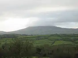
Slieve Croob (from Irish Sliabh Crúibe 'mountain of the hoof')[1] is a mountain with a height of 534 metres (1,752 ft)[2] in the middle of County Down, Northern Ireland. It is the heart of a mountainous area known as the Dromara Hills, north of the Mourne Mountains. It is designated an Area of Outstanding Natural Beauty and is the source of the River Lagan. There is a small road to the summit, where there is an ancient burial cairn and several transmitter stations with radio masts. It has wide views over all of County Down and further afield. The Dromara Hills also includes Slievenisky, Cratlieve, Slievegarran and Slievenaboley.
| Slieve Croob | |
|---|---|
| Sliabh Crúibe | |
 | |
| Highest point | |
| Elevation | 534 m (1,752 ft) |
| Prominence | 439 m (1,440 ft) |
| Listing | Marilyn |
| Coordinates | 54°20′24″N 5°58′25″W |
| Naming | |
| English translation | mountain of the hoof |
| Language of name | Irish |
| Geography | |
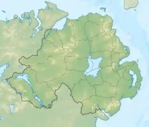 Slieve Croob shown within Northern Ireland | |
| Location | County Down, Northern Ireland |
| Parent range | Dromara Hills |
| OSI/OSNI grid | J318453 |
Slieve Croob may have been the mountain named Brí Erigi or Brí Airige in medieval writings.[3] The cairn on its summit is believed to be the remains of an ancient burial mound, possibly of a passage tomb like the one on Slieve Gullion.[4] In the 19th century it was recorded to be 77 yards (70 m) around and 18 yards (16 m) in "conical height", with forty-two "pillar stones" or kerbstones around the edge.[5] The cairn would have had a well-defined shape when it was built, but over time it has slipped and been damaged by visitors. Irish folklore holds that it is bad luck to damage such cairns.[6][7] Some of its stones have been piled into smaller cairns on top of it,[4] which led to the summit being nicknamed 'The Twelve Cairns'.[3] Traditionally, people would gather on the summit at Lughnasadh where they would add a stone to one of the cairns. They would collect and eat bilberries and there would be folk music, dancing and games.[8]
Legannany Dolmen sits on the southern slopes of Slieve Croob near the village of Leitrim.[9]
Gallery
_-_geograph.org.uk_-_1739100.jpg.webp) Slieve Croob from the west, covered with patches of snow
Slieve Croob from the west, covered with patches of snow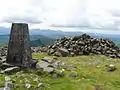 The summit, looking towards the Mournes
 Communications towers on Slieve Croob
References
- Mills, A. D. (2003). A Dictionary of British Place-Names. Oxford University Press. Retrieved 2009-01-20.
- Slieve Croob at MountainViews.ie
- Slieve Croob at Place Names NI.
- Moore, Sam (2012). The Archaeology of Slieve Donard: a Cultural Biography of Ulster's Highest Mountain. Down County Museum. p. 39. ISBN 978-0-9567278-6-2.
- Philip Dixon Hardy. The Northern Tourist; Or, Stranger's Guide to the North and North West of Ireland. Curry, 1830. p.70
- Sarah Champion & Gabriel Cooney. "Chapter 13: Naming the Places, Naming the Stones". Archaeology and Folklore. Routledge, 2005. p.193
- Doherty, Gillian. The Irish Ordnance Survey: History, Culture and Memory. Four Courts Press, 2004. p.89
- Moore, Sam (2012). The Archaeology of Slieve Donard: a Cultural Biography of Ulster's Highest Mountain. Down County Museum. p. 64. ISBN 978-0-9567278-6-2.
- "Banbridge". Travel Now. Retrieved 2007-12-11.
Mountains and hills of Ulster | ||
|---|---|---|
| Antrim Hills | 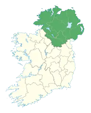 | |
| Antrim Plateau | ||
| Belfast Hills | ||
| Croaghgorms | ||
| Derryveagh | ||
| Inishowen | ||
| Mournes | ||
| Sperrins | ||
| Southwest Donegal | ||
| Others | ||