Sorong Regency
Sorong Regency (Indonesian: Kabupaten Sorong) is a regency of West Papua Province of Indonesia.[2] It covers an area of 7,415.29 km2, and had a population of 70,619 at the 2010 Census,[3] and 80,479 at the 2015 Census.[4] Its administrative centre is the town of Aimas. The regency surrounds Sorong City (Kota), which is independent of the Regency; Sorong City has an airport, Sorong Airport, which also serves the Regency.
Sorong Regency
Kabupaten Sorong | |
|---|---|
 Coat of arms | |
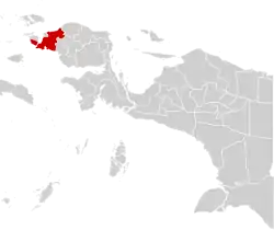 Location in Indonesian Papua | |
 Sorong Regency Location in Indonesia | |
| Coordinates: 0°52′59″S 131°15′00″E | |
| Country | Indonesia |
| Province | West Papua |
| Capital | Aimas |
| Government | |
| • Regent | Johny Kamuru |
| • Vice Regent | Suko Hardjono |
| Area | |
| • Total | 7,415.29 km2 (2,863.06 sq mi) |
| Population (2015 Census)[1] | |
| • Total | 80,478 |
| • Density | 11/km2 (28/sq mi) |
| Time zone | UTC+9 (Indonesia Eastern Time) |
| Area code | (+62) 951 |
| Website | sorongkab |
Administrative Districts
Sorong Regency comprises eighteen districts (kecamatan), tabulated below with their populations at the 2010 Census:[5]
Administration
At the 2010 Census, the Sorong Regency was divided into eighteen administrative districts (kecamatan). The districts are tabulated below with their areas and their 2010 Census populations,[6] together with their estimated populations in mid 2013:[7] However, since 2013 Moraid District has been transferred to the expanded Tambrauw Regency, while thirteen additional districts have been created in Soring Regency by the division of existing districts; area and population data for these are not yet available.
The table also includes the number of administrative villages (226 rural desa and 26 urban kelurahan) in each district and its post code; these are shown for all 30 of the present districts.
| Name | Area in km2 | Pop'n Census 2010[8] | Pop'n Estimate mid 2013[9] | No. of vill. | Post code |
|---|---|---|---|---|---|
| Moraid | 1,446.16 | 1,727 | - | 9 | 98361 |
| Klaso | 316.42 | 306 | 336 | 7 | 98456 |
| Makbon | 1,011.42 | 2,130 | 2,262 | 15 | 98452 |
| Klayili | 481.26 | 416 | 443 | 8 | 98451 |
| Beraur | 822.26 | 1,007 | 1,074 | 13 | 98432 |
| Klamono | 488.45 | 4,483 | 4,778 | 10 | 98441 |
| Klabot | 518.72 | 638 | 694 | 8 | 98436 |
| Klawak | 492.89 | 597 | 651 | 12 | 98437 |
| Salawati | 525.03 | 9,149 | 9,989 | 7 | 98423 |
| Mayamuk | 217.22 | 9,983 | 10,939 | 11 | 98421 |
| Salawati Timur (East Salawati) or Moisegen | 118.62 | 1,952 | 2,079 | 9 | 98422 |
| Seget | 893.81 | 3,087 | 3,282 | 9 | 98426 |
| Segun | 2,021.37 | 1,369 | 1,515 | 9 | 98427 |
| Salawati Selatan (South Salawati) | 2,265.18 | 2,057 | 2,190 | 6 | 98424 |
| Aimas | 222.43 | 19,911 | 23,000 | 14 | 98444 |
| Mariat | 118.16 | 10,432 | 11,962 | 11 | 98445 |
| Sayosa | 1,213.60 | 988 | 1,052 | 6 | 98453 |
| New districts: | |||||
| Bagun | 9 | 98431 | |||
| Botain | 4 | 98433 | |||
| Buk | 7 | 98434 | |||
| Hobard | 7 | 98435 | |||
| Klasafet | 5 | 98442 | |||
| Konhir | 8 | 98438 | |||
| Malabotom | 9 | 98443 | |||
| Saengkeduk | 6 | 98458 | |||
| Salawati Tengah (Central Salawati) | 10 | 98425 | |||
| Sayosa Timur (East Sayosa) | 6 | 98454 | |||
| Sorong (district) | 4 | 98446 | |||
| Sunook | 7 | 98459 | |||
| Wemak | 6 | 98455 | |||
| Totals | 7,415.25 | 68,902 | 76,669 | 252 | |
Note that Salawati Selatan District lies on the island of Salawati and is thus geographically part of the Raja Ampat island group. (Conversely, Salamati District and Salawati Timur District - the latter also called Moisegen district - do not lie on the island, but on the Papuan 'mainland'.)
Climate
Aimas, the seat of the regency has a tropical rainforest climate (Af) with heavy to very heavy rainfall year-round. Unlike most parts of Indonesia, it experiences a rainfall maximum during the low-sun season due to local wind currents.
| Climate data for Aimas | |||||||||||||
|---|---|---|---|---|---|---|---|---|---|---|---|---|---|
| Month | Jan | Feb | Mar | Apr | May | Jun | Jul | Aug | Sep | Oct | Nov | Dec | Year |
| Average high °C (°F) | 30.6 (87.1) |
30.5 (86.9) |
30.5 (86.9) |
30.6 (87.1) |
30.5 (86.9) |
29.9 (85.8) |
29.3 (84.7) |
29.3 (84.7) |
29.8 (85.6) |
30.6 (87.1) |
30.9 (87.6) |
30.7 (87.3) |
30.3 (86.5) |
| Daily mean °C (°F) | 27.4 (81.3) |
27.3 (81.1) |
27.4 (81.3) |
27.4 (81.3) |
27.4 (81.3) |
27.0 (80.6) |
26.5 (79.7) |
26.4 (79.5) |
26.8 (80.2) |
27.3 (81.1) |
27.6 (81.7) |
27.6 (81.7) |
27.2 (80.9) |
| Average low °C (°F) | 24.2 (75.6) |
24.1 (75.4) |
24.4 (75.9) |
24.2 (75.6) |
24.3 (75.7) |
24.1 (75.4) |
23.7 (74.7) |
23.6 (74.5) |
23.8 (74.8) |
24.0 (75.2) |
24.3 (75.7) |
24.3 (75.7) |
24.1 (75.4) |
| Average rainfall mm (inches) | 215 (8.5) |
205 (8.1) |
223 (8.8) |
258 (10.2) |
392 (15.4) |
390 (15.4) |
348 (13.7) |
317 (12.5) |
272 (10.7) |
233 (9.2) |
201 (7.9) |
205 (8.1) |
3,259 (128.5) |
| Source: Climate-Data.org[10] | |||||||||||||
References
- Badan Pusat Statistik, Jakarta, 2019.
- http://www.petra.ac.id/eastern/irian/cities/sorong/sorong.html%5B%5D
- Biro Pusat Statistik, Jakarta, 2011.
- Badan Pusat Statistik, Jakarta, 2019.
- Biro Pusat Statistik, Jakarta, 2011.
- Biro Pusat Statistik, Jakarta, 2011.
- Badan Pusat Statistik, Jakarta, 2020.
- Biro Pusat Statistik, Jakarta, 2011.
- Badan Pusat Statistik, Jakarta, 2020.
- "Climate: Aimas". Climate-Data.org. Retrieved 24 November 2020.