South Sorong Regency
South Sorong Regency (Indonesian: Sorong Selatan) is a regency of West Papua province of Indonesia. It has an area of 7,789.92 km2, and had a population of 37,900 at the 2010 Census;[2] the latest official estimate (as at mid 2018) is 46,021.[3] The administrative centre is the town of Teminabuan.
South Sorong Regency
Kabupaten Sorong Selatan | |
|---|---|
 Seal | |
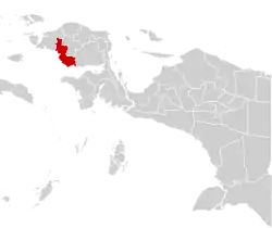 Location in Indonesian Papua | |
 South Sorong Regency Location in Indonesia | |
| Coordinates: 1.5050°S 132.2864°E | |
| Country | |
| Region | Western New Guinea |
| Province | |
| Capital | Teminabuan |
| Government | |
| • Regent | Samsudin Anggiluli |
| • Vice Regent | Marthinus Salamuk |
| Area | |
| • Total | 7,789.92 km2 (3,007.70 sq mi) |
| Population (2018)[1] | |
| • Total | 46,021 |
| • Density | 5.9/km2 (15/sq mi) |
| Time zone | UTC+9 (Indonesia Eastern Time) |
| Area code | (+62) 952 |
| Website | sorongselatankab.go.id |
Languages
Languages spoken in South Sorong Regency include Inanwatan, Yahadian, Kais, Kokoda, Konda, and Puragi.[4]
Administrative Districts
South Sorong Regency comprises fifteen districts (kecamatan), tabulated below with their populations at the 2010 Census[5] and the more recent official estimates (for mid 2018).[6] The table also includes the number of administrative villages (desa and kelurahan) in each district and its post code.
| Name | Area in km2 | Pop'n Census 2010[7] | Pop'n mid 2018 Estimate[8] | No. of vill. | Post code |
|---|---|---|---|---|---|
| Inanwaten | 960.56 | 2,811 | 3,566 | 9 | 98223 |
| Kokoda | 3,037.76 | 5,876 | 7,398 | 16 | 98221 |
| Kokoda Utara (North Kokoda) | 534.36 | 1,666 | 2,096 | 9 | 98224 |
| Kais | 3,099.95 | 2,841 | 2,655 | 5 | 98222 |
| Kais Darat | (a) | (a) | 928 | 7 | 98226 |
| Matemani | 531.51 | 2,115 | 2,664 | 16 | 98225 |
| Moswaren | 407.81 | 2,130 | 2,563 | 7 | 98212 |
| Teminabuan | 388.10 | 11,627 | 13,851 | 16 | 98216 |
| Konda | 612.72 | 1,883 | 2,192 | 5 | 98211 |
| Seremuk | 208.06 | 1,159 | 1,344 | 8 | 98214 |
| Saifi | 931.84 | 1,747 | 2,008 | 10 | 98213 |
| Wayer | 317.90 | 1,455 | 1,752 | 8 | 98215 |
| Sawiat | 453.64 | 1,831 | 1,211 | 8 | 98232 |
| Salkma | (b) | (b) | 881 | 5 | 98233 |
| Fkour | 305.03 | 759 | 912 | 4 | 98231 |
| Totals | 7,789.92 | 18,564 | 46,021 | 123 |
Notes: (a) the area and 2010 population of Kais Darat District are included in the figures for Kais District, from which it was later split.
(b)the area and 2010 population of Salkma District are included in the figures for Sawiat District, from which it was later split.
References
- Badan Pusat Statistik, Jakarta, 2020.
- Biro Pusat Statistik, Jakarta, 2011.
- Badan Pusat Statistik, Jakarta, 2020.
- Eberhard, David M.; Simons, Gary F.; Fennig, Charles D., eds. (2019). "Indonesia languages". Ethnologue: Languages of the World (22nd ed.). Dallas: SIL International.
- Biro Pusat Statistik, Jakarta, 2011.
- Badan Pusat Statistik, Jakarta, 2020.
- Biro Pusat Statistik, Jakarta, 2011.
- Badan Pusat Statistik, Jakarta, 2020.
External links
Regencies and cities of West Papua | ||
|---|---|---|
Capital: Manokwari | ||
| Regencies | ||
| Cities | ||