South Uniontown, Pennsylvania
South Uniontown is a census-designated place in South Union Township, Fayette County, Pennsylvania, United States. As of the 2010 census the population was 1,360.[1]
South Uniontown, Pennsylvania | |
|---|---|
 South Uniontown  South Uniontown | |
| Coordinates: 39°53′38″N 79°44′48″W | |
| Country | United States |
| State | Pennsylvania |
| County | Fayette |
| Township | South Union |
| Area | |
| • Total | 0.5 sq mi (1.2 km2) |
| • Land | 0.5 sq mi (1.2 km2) |
| • Water | 0.0 sq mi (0.0 km2) |
| Elevation | 1,076 ft (328 m) |
| Population (2010) | |
| • Total | 1,360 |
| • Density | 2,991/sq mi (1,154.7/km2) |
| Time zone | UTC-5 (Eastern (EST)) |
| • Summer (DST) | UTC-4 (EDT) |
| FIPS code | 42-72552 |
| GNIS feature ID | 2633311 |
The community borders the southwest side of the city of Uniontown, the Fayette County seat. U.S. Route 119 and U.S. Route 40, a four-lane bypass of the city and in this area part of the Mon–Fayette Expressway, form the western edge of the CDP.
According to the U.S. Census Bureau, the South Uniontown CDP has a total area of 0.46 square miles (1.2 km2), all of it land.[1]
References
- "Geographic Identifiers: 2010 Census Summary File 1 (G001), South Uniontown CDP, Pennsylvania". American FactFinder. U.S. Census Bureau. Archived from the original on February 13, 2020. Retrieved July 27, 2016.
External links
Municipalities and communities of Fayette County, Pennsylvania, United States | ||
|---|---|---|
| Cities | 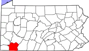 | |
| Boroughs | ||
| Townships | ||
| CDPs | ||
| Unincorporated communities |
| |
| Footnotes | ‡This populated place also has portions in an adjacent county or counties | |
| ||
This article is issued from Wikipedia. The text is licensed under Creative Commons - Attribution - Sharealike. Additional terms may apply for the media files.