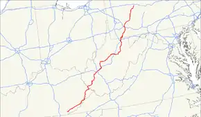
U.S. Route 119
U.S. Route 119 (US 119) is a spur of US 19. It is a north–south route (on a northeast-southwest alignment) that was an original United States highway of 1926. It is Corridor G of the Appalachian Development Highway System (ADHS) east of US 23 and KY 80 in Kentucky to Interstate 64 at Charleston, West Virginia.
| |||||||
|---|---|---|---|---|---|---|---|
 | |||||||
| Route information | |||||||
| Auxiliary route of US 19 | |||||||
| Length | 585 mi (941 km) | ||||||
| Existed | 1926–present | ||||||
| Major junctions | |||||||
| South end | |||||||
| |||||||
| North end | |||||||
| Location | |||||||
| States | Kentucky, West Virginia, Pennsylvania | ||||||
| Highway system | |||||||
| |||||||

Route description
Kentucky
In Kentucky, US 119 is a two- and four-lane highway running from Pineville at U.S. Route 25E to the West Virginia state line at South Williamson. It follows the Cumberland River past Harlan to near the source of the river's Poor Fork, crosses Pine Mountain south of Whitesburg, then follows a meandering course along the mountain to Jenkins, where it joins US 23 and turns north to Pikeville. Just north of Pikeville it turns east to South Williamson, where it crosses the Tug Fork of the Big Sandy River into Williamson, W.Va.
From Pineville to US 23 (Country Music Highway) at Jenkins, it is part of ADHS Corridor F. In its concurrency from Jenkins north to Pikeville, where it heads east toward West Virginia, it is part of Corridor B. From US 23/KY 80 at Pikeville eastward towards the state line, it is part of Corridor G.
West Virginia
_at_West_Virginia_State_Route_36_(Clay_Road)_just_south_of_Spencer_in_Roane_County%252C_West_Virginia.jpg.webp)
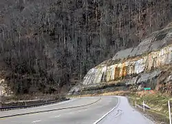
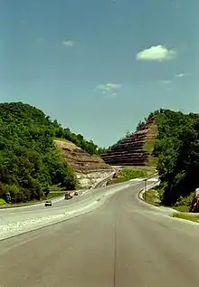
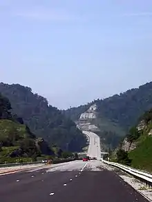
U.S. Route 119 enters West Virginia from Kentucky as unsigned AHDS Corridor G, a four-lane limited-access highway stretching from Williamson to Charleston. The earliest segment of Corridor G to open was in 1972 and was finished in 1997. Formerly, US 119 was a typical two-lane mountain highway. Old US 119 now comprises all or parts of US 52, WV 44, WV 10, WV 17, WV 85, WV 3, WV 94 and WV 61.
The US route becomes a mostly two-lane highway north of Charleston, having functionally been replaced by Interstate 79. Compared to its replacement, US 119 takes a rather winding course. A trip from the Charleston area to the Morgantown area (I-79/US 119 Exit #1 to I-68 Exit #1) is 147 miles (237 km) via I-79 and 182 miles (293 km) via US 119. The travel time is about double taking US 119, over 4 hours instead of about 2 hours.
From Charleston, US 119 heads roughly east along the Elk River to Clendenin, where it turns north for 29 miles (47 km) to Spencer. At Spencer, it begins to head east with US 33 for 81.4 miles (131.0 km). Along the way, it passes through Glenville and Weston, where it intersects parent route US 19 and replacement I-79. From I-79 to WV 20 at Buckhannon, US 33/US 119 follow Corridor H.
At Buckhannon, US 119 again turns north — first with WV 20 then by itself as it travels to Philippi. At Philippi it joins with US 250 for 12 miles (19 km). From there, US 119 heads on its own through Grafton and towards Morgantown.
Just south of Morgantown, US 119 intersects Interstate 68's Exit #1, immediately east of its end at I-79. US 119 then enters downtown Morgantown, again meeting with US 19. It leaves town via the narrow and winding North Willey Street and congested Mileground.
Just after the Mileground, US 119 intersects with the Monongalia County Route 857 connector to I-68 Exit #7, which effectively allows through traffic to bypass Morgantown. US 119 finally turns north to enter Pennsylvania near Point Marion. The Hamilton Farm Petroglyphs are along this section. Much of this last stretch of US 119 heading towards Uniontown, Pennsylvania is already bypassed by traffic using I-68, CR 857, and PA 857. While this alternate route is longer, it has a better alignment and is faster to travel.[1]
Pennsylvania
US 119 travels through Connellsville, Greensburg, and Punxsutawney, and bypasses Uniontown and Indiana. There are numerous other boroughs and villages along its 133-mile (214 km) route in the Keystone State.
The southern entrance of US 119 is at the West Virginia state line one-half mile south of Point Marion. The northern terminus is at US 219 two miles (3 km) south of DuBois, Pennsylvania.
US 119's control cities include Morgantown, West Virginia, Uniontown, Connellsville, New Stanton (for northbound traffic only), Greensburg, Blairsville, Indiana, Punxsutawney, and DuBois.
History
US 23 / US 123
| |
|---|---|
| Location | Pineville, KY—Jenkins, KY |
| Existed | 1930–1934 |
In 1929 U.S. Route 23, which then ended at Jenkins, KY, was extended to Pineville. The following year this section was renumbered to U.S. Route 123, to allow US 23 to be extended in a different direction (towards Kingsport TN). In 1934 US 119 was extended from Morgantown WV into Kentucky, joining US 123 at Jenkins; US 123 was then renumbered to US 119.
Kentucky
Hwy 119 in Kentucky was originally a series of two-lane roads paralleling Pine Mountain that connected Pineville to Baxter (just north of Harlan) and then headed northeast through Cumberland, Whitesburg, and Pikeville en route to West Virginia.
Starting in the 1970s, there were a number of projects that widened or replaced sections of the road. In most places, the original route has been largely abandoned, instead cutting through the mountain to provide a much wider and straighter route. Small segments of the original route are still in existence as access roads to communities that predate the expansion. In Loyall the original route is known as Hwy 413, and this parallels Hwy 119 heading northeast until it reaches the community of Rosspoint. During this stretch in Baxter, Hwy 119 also briefly combines with U.S. Route 421, which then splits off and heads north across Pine Mountain. In Rosspoint, the original route of Hwy 119 is designated as Hwy 522. Hwy 522 parallels Hwy 119 all the way to Cumberland, where the final stretch of original highway is called Kingdom Come Dr. before merging with Hwy 119 just south of the Harlan County/Letcher County border.
From this point until the base of Pine Mountain (unofficially called Whitesburg Mountain), the highway is largely unchanged from its original route. On the mountain, Hwy 119 has recently been widened in a number of places in order to make it safer for trucking traffic.
Across the mountain in Whitesburg, Hwy 119 turns northeast. South of Jenkins, Hwy 119 merges with U.S. Route 23 until Pikeville, where it splits off and heads northeast to the West Virginia border.
In 2007, a 6-mile stretch of Hwy 119 northeast of Pikeville, was expanded and improved by cutting through the mountain, once again abandoning the original route which is now known as the Zebulon Hwy. and Bent Branch Rd. Past this point, Hwy 119 follows its original route until exiting Kentucky at South Williamson.
West Virginia
The routing of US 119 south of Charleston changed drastically with the opening of Corridor G from 1972 to 1997.
The original routing southeast of the capital was WV 61 to Marmet, where it took WV 94 southwest to Racine.[2] From Racine to Danville, it followed today's WV 3 and onward to Madison. From Madison south to Logan, it followed today's WV 17.
South of Logan to Mountain View, it followed WV 44. At Mountain View, it intersected US 52 and traveled concurrently with it to the northwest, to Williamson, where it entered Kentucky.
Corridor G
| |
|---|---|
| |
| Route information | |
| Length | 106.5 mi[3] (171.4 km) |
| Existed | 1965 (Completed 2008)–present |
| Major junctions | |
| South end | |
| North end | |
| Highway system | |
|
| |
Corridor G is a highway in Kentucky and West Virginia. It is part of the Appalachian Development Highway System, encompassing US 119 for its length. At the southern terminus of Corridor G at Corridor B (US 23/US 460/KY 80) near Pikeville, Kentucky, traffic can continue along Corridor B towards Pikeville and Jenkins, where one can pick up Corridor F (US 119) or proceed south on Corridor B (US 23) into Virginia. At the northern terminus at Interstate 64 in Charleston, West Virginia, one can pick up Interstate 77 and Interstate 79, along with the West Virginia Turnpike.
The Hatfield–McCoy Trails are an ATV and mountain biking network of trails throughout southwest West Virginia. Three trail heads branch off from various secondary routes accessible from Corridor G.
Kentucky
In 1974,[4] the first segment of Corridor G was completed from KY 292 (2nd St.) at South Williamson south to KY 199 at Huddy. This was a four-lane divided highway that contained mountable medians and jersey barriers, with a mix of state route and driveway access. This is especially evident as US 119 cuts through the center of Belfry and South Williamson. Several years later, a 2.5-mile (4.0 km) segment of four-lane US 119 along Buckley Creek opened from Corridor B/US 23/US 460/KY 80 north of Pikeville to what is now KY 1426 3.5 miles (5.6 km) northeast of Pikeville.
In 1997,[4] a section of US 119 was relocated on new alignment from KY 3154 (Meathouse Fork Rd.) at Canada east to KY 199 at Huddy. Two years later,[4] a section of US 119 was relocated on new alignment from 2.5 miles (4.0 km) east of Meta to KY 3154 at Canada. This involved extensive highwall construction at Bent Mountain and Canada Knob.
The final segment of Corridor G in Kentucky to be completed was from the KY 1426 intersection north of Pikeville east to Scott Fork 2.5 miles (4.0 km) east of Meta. This segment required the construction of three twin steel-box girder bridges at Johns Creek (KY 194) near Bevins Branch, Winn Branch (Winn Branch Road), and Raccoon Creek (KY 1441).[5] This also includes a modified diamond interchange at what will be old US 119 1/2-mile east of KY 1426 at Zebulon.
On June 30, 2006, the "Pinson Family Bridge" was dedicated. It crosses Raccoon Creek and KY 1441. This twin steel-box girder bridge is more than 1,200 ft (370 m) long and is the only example of its kind in Kentucky.[6] The girders were chosen because of the curvature within the bridge structure; each girder is completely hollow and it features a 10 ft (3.0 m). clearance on the interior.
On December 6, 2006, a segment of Corridor G opened from the KY 1426 intersection north of Pikeville east to the KY 194 (Johns Creek) interchange.[7] The last segment to open is from KY 194 north to Scott Fork. That segment was opened in March 2008.
West Virginia
The first segments of Corridor G to open was in 1972.[8] During that year, a Mingo County segment from Myrtle and Belo (MP 13) to the Logan County line near Holden opened. Segments of this were opened originally as a "super-two" since WV 65 was being destroyed; it was critical that the old roadway be removed before the highway was expanded to four-lanes.
In 1973, a lengthy segment opened to traffic from Godby Heights south of Chapmanville (MP 13) to MP 4 in Boone County.[8] This was followed a year later by a segment near Madison from MP 9.37 to MP 13 in Boone County. In 1975, the segment from MP 4 to MP 9.37 in Boone County was opened to traffic. At this time, the connection to Interstate 64 in Charleston also opened to traffic from Oakwood Road. This included the flyover ramp from US 119 to the Interstate 64 interchange.
In 1977, a Mingo County segment from Nolan (MP 7.45) at US 52 to Myrtle (MP 13) opened to traffic.[8]
The next segment to open would come in 1982,[8] when a Boone, Lincoln, and Kanawha County segment opened to traffic from Julian (MP 17) to the WV 601 interchange in South Charleston (MP 11). The segment between the WV 601 interchange to Oakwood Road in Charleston would be completed in 1986;[8] it formerly utilized Oakhurst and Oakwood Roads.
In 1989,[8] a segment from MP 13 to Julian (MP 17) in Boone County opened. In 1992, a new Tug Fork crossing at Williamson was completed. Formerly, Corridor G traffic from Kentucky had to cross into downtown Williamson and pick up US 119 into West Virginia.
The last segment of Corridor G in West Virginia to be completed was from the Tug Fork crossing at Williamson north to US 52 near Nolan. This nine-mile (14 km) segment was completed in 1997.[8]
Major intersections
| State | County | Location | mi[9] [10] | km | Destinations | Notes |
|---|---|---|---|---|---|---|
| Kentucky | Bell | Pineville | 0.000 | 0.000 | Southern terminus | |
| Cumberland River | 0.014– 0.140 | 0.023– 0.225 | Joan Asher Cawood Bridge | |||
| | 1.496 | 2.408 | Western terminus of KY 987 | |||
| | 5.074 | 8.166 | Northern terminus of KY 1344 | |||
| | 7.796 | 12.546 | South end of KY 987 overlap | |||
| | 7.939 | 12.777 | North end of KY 987 overlap | |||
| | 10.401 | 16.739 | Northern terminus of KY 3482 | |||
| | 10.655 | 17.148 | Northern terminus of KY 2012 | |||
| | 13.949 | 22.449 | Western terminus of KY 72 | |||
| Harlan | | 19.707 | 31.715 | Western terminus of KY 2007 | ||
| | 20.054 | 32.274 | Northern terminus of KY 3467 | |||
| | 21.462 | 34.540 | Northern terminus of KY 219 | |||
| | 21.860 | 35.180 | Northern terminus of KY 3461 | |||
| | 23.667 | 38.088 | Western terminus of KY 840 | |||
| | 25.069 | 40.345 | Northern terminus of KY 3451 | |||
| | 25.848 | 41.598 | Dayhoit Drive (KY 3152 west) | Eastern terminus of KY 3152 | ||
| | 25.955 | 41.771 | South end of KY 840 overlap | |||
| | 26.039 | 41.906 | North end of KY 840 overlap | |||
| | 27.364 | 44.038 | Western terminus of KY 3452 | |||
| | 28.105 | 45.231 | Four Mile Road (KY 3452 west) | Eastern terminus of KY 3452 | ||
| | 28.315 | 45.569 | Eastern terminus of KY 1084 | |||
| | 28.492 | 45.853 | Northern terminus of KY 3460 | |||
| | 29.093 | 46.821 | South end of US 421 overlap | |||
| | 29.832 | 48.010 | North end of US 421 overlap | |||
| Rosspoint | 31.610 | 50.871 | Southern terminus of KY 522 | |||
| | 37.803 | 60.838 | Southern terminus of KY 2010 | |||
| Cumberland | 49.636 | 79.881 | Northern terminus of KY 179 | |||
| 49.830 | 80.194 | |||||
| 50.753 | 81.679 | Interchange | ||||
| | 51.618 | 83.071 | Eastern terminus of KY 1254 | |||
| | 55.019 | 88.544 | Montgomery Road (KY 3464 west) / Arvel Lane | Eastern terminus of KY 3464 | ||
| Letcher | | 55.150 | 88.755 | Southern terminus of KY 3073 | ||
| | 55.857 | 89.893 | Northern terminus of KY 3403 | |||
| | 56.842 | 91.478 | Southern terminus of KY 3619 | |||
| | 61.035 | 98.226 | Eastern terminus of KY 2564 | |||
| | 62.518 | 100.613 | Northern terminus of KY 3619 | |||
| | 62.989 | 101.371 | Northern terminus of KY 806 | |||
| | 63.899 | 102.835 | Western terminus of KY 932 | |||
| | 69.184 | 111.341 | Eastern terminus of KY 2035 | |||
| Whitesburg | 70.834 | 113.996 | Southern terminus of KY 15 / KY 15 Bus. | |||
| 71.793 | 115.540 | Eastern terminus of KY 2034 Conn | ||||
| Mayking | 18.623 | 29.971 | ||||
| | 75.318 | 121.213 | Western terminus of KY 3406 | |||
| | 76.464 | 123.057 | Western terminus of KY 805 | |||
| | 79.544 | 128.014 | Western terminus of KY 3400 | |||
| Payne Gap | 80.831 | 130.085 | Eastern terminus of KY 3400 | |||
| | 81.557– 81.751 | 131.253– 131.565 | Partial interchange; south end of US 23 overlap | |||
| Jenkins | 81.966 | 131.911 | Western terminus of KY 3086 | |||
| 82.926 | 133.456 | |||||
| Pike | | 91.129 | 146.658 | Southern terminus of KY 3527 | ||
| | 92.121 | 148.254 | Eastern terminus of KY 805 | |||
| | 95.757 | 154.106 | Northern terminus of KY 611 | |||
| | 99.577 | 160.254 | Eastern terminus of KY 1469 | |||
| | 101.653 | 163.595 | Northern terminus of KY 2167 | |||
| | 102.969 | 165.713 | Exit 15; Western terminus of KY 3174 | |||
| Pikeville | 106.570– 106.840 | 171.508– 171.942 | South end of US 460 / KY 80 overlap | |||
| 110.726 | 178.196 | South end of KY 1426 overlap | ||||
| 110.848 | 178.393 | Southern terminus of KY 3496 | ||||
| 111.363– 111.502 | 179.221– 179.445 | North end of KY 1426 overlap | ||||
| 112.131 | 180.457 | |||||
| 112.610 | 181.228 | Northern terminus of KY 1460 | ||||
| 113.394 | 182.490 | Northern terminus of KY 3495 | ||||
| 114.076 | 183.588 | |||||
| | 116.748 | 187.888 | south end of KY 1426 overlap | |||
| | 116.870– 117.438 | 188.084– 188.998 | Interchange; north end of KY 1426 overlap | |||
| | 122.363 | 196.924 | Interchange | |||
| | 123.843 | 199.306 | interchange | |||
| | 124.556 | 200.453 | Southern terminus of KY 881 | |||
| | 127.473 | 205.148 | Partial interchange; northbound exit and entrance only; western terminus of KY 3220 | |||
| | 130.619 | 210.211 | Partial interchange; southbound exit and entrance only | |||
| | 130.865 | 210.607 | Partial interchange; southbound exit and entrance only; eastern terminus of KY 3220 | |||
| | 132.796 | 213.714 | Northern terminus of KY 199 | |||
| | 136.648 | 219.914 | Northern terminus of KY 319 | |||
| | 137.543 | 221.354 | Eastern terminus of KY 308 | |||
| | 138.669 | 223.166 | south end of KY 292 overlap | |||
| | 139.053 | 223.784 | 2nd Avenue (KY 1506 north) | Southern terminus of KY 1506 | ||
| South Williamson | 139.445 | 224.415 | north end of KY 292 overlap; south end of US 52 Truck overlap (northbound only); southern terminus of US 119 Spur | |||
| Tug Fork | 139.797– 0.0 | 224.981– 0.0 | USAF General Robert H. Foglesong Bridge; Kentucky–West Virginia state line | |||
| West Virginia | Mingo | Williamson | 0.07 | 0.11 | north end of US 52 Truck overlap (northbound only); south end of US 52 overlap | |
| Kentucky | Pike | | 139.897 | 225.142 | ||
| West Virginia | Mingo | | 1.8 | 2.9 | ||
| Kentucky | Pike | | 140.097 | 225.464 | ||
| West Virginia | Mingo | Nolan | 4.7 | 7.6 | To Nolan Toll Bridge | |
| | 6.4 | 10.3 | North end of US 52 overlap | |||
| | 10.8 | 17.4 | South end of WV 65 overlap | |||
| Belo | 11.3 | 18.2 | north end of WV 65 overlap | |||
| Logan | Holden | 22.7 | 36.5 | former US 119 north | ||
| 23.7 | 38.1 | Copperas Fork Road - Holden | ||||
| Holden–Mount Gay-Shamrock line | 24.6 | 39.6 | Whitman Junction (CR 209/1) | |||
| | 26.0 | 41.8 | Interchange; western terminus of WV 73 | |||
| Chapmanville | 35.9 | 57.8 | Interchange | |||
| Boone | Danville | 50.6 | 81.4 | |||
| | 51.3– 51.5 | 82.6– 82.9 | ||||
| Rock Creek | 52.0 | 83.7 | south end of WV 3 overlap | |||
| Julian | 57.2 | 92.1 | north end of WV 3 overlap | |||
| Lincoln | Priestley | 65.6 | 105.6 | |||
| Kanawha | | 71.3 | 114.7 | to WV 214 | ||
| Ruth | 72.5 | 116.7 | ||||
| Charleston | 73.9 | 118.9 | ||||
| 75.4 | 121.3 | interchange | ||||
| 77.7 | 125.0 | |||||
| 78.3– 78.6 | 126.0– 126.5 | Partial interchange | ||||
| South end of I-64 overlap; I-64 exit 58A | ||||||
| Kanawha River | 79.2 | 127.5 | Eugene A. Carter Memorial Bridge | |||
| Charleston | 79.2 | 127.5 | North end of I-64 overlap; access only from I-64 east off to US 119 north and US 119 south onto I-64 west; I-64 exit 58B | |||
| 79.6 | 128.1 | |||||
| 79.7 | 128.3 | |||||
| | 83.7– 83.8 | 134.7– 134.9 | I-79 exit 1 | |||
| | 86.9 | 139.9 | ||||
| Elkview | 91.8 | 147.7 | ||||
| Clendenin | 100.4 | 161.6 | Western terminus of WV 4 | |||
| | 101.3 | 163.0 | ||||
| | 103.0 | 165.8 | ||||
| Roane | Cotton | 105.6 | 169.9 | |||
| | 128.3 | 206.5 | Northern terminus of WV 36 | |||
| Spencer | 129.0 | 207.6 | South end of US 33 overlap | |||
| Calhoun | Liberty Hill | 140.4 | 226.0 | |||
| | 142.1 | 228.7 | ||||
| Arnoldsburg | 143.2 | 230.5 | South end of WV 16 overlap | |||
| Millstone | 145.0 | 233.4 | North end of WV 16 overlap | |||
| Gilmer | | 152.6 | 245.6 | |||
| | 155.4 | 250.1 | ||||
| Normantown | 158.0 | 254.3 | ||||
| | 164.6 | 264.9 | ||||
| Glenville | 168.2 | 270.7 | South end of WV 5 overlap | |||
| 169.3 | 272.5 | North end of WV 5 overlap | ||||
| | 171.1 | 275.4 | ||||
| | 176.5 | 284.0 | ||||
| Linn | 178.3 | 286.9 | Eastern terminus of WV 47 | |||
| Lewis | Camden | 189.4 | 304.8 | |||
| Weston | 194.3 | 312.7 | ||||
| 195.4 | 314.5 | North River Avenue (CR 1) | ||||
| 195.5– 195.6 | 314.6– 314.8 | South end of US 19 overlap | ||||
| 195.7 | 314.9 | North end of US 19 overlap | ||||
| | 198.2– 198.5 | 319.0– 319.5 | I-79 exit 99; south end of US 48 overlap; western terminus of US 48 | |||
| | 201.2 | 323.8 | ||||
| Upshur | Buckhannon | 210.3– 210.5 | 338.4– 338.8 | North end of US 33 / US 48 overlap; south end of WV 20 overlap | ||
| | 216.9 | 349.1 | North end of WV 20 overlap | |||
| Barbour | | 220.0 | 354.1 | |||
| | 228.2 | 367.3 | Eastern terminus of WV 57 | |||
| Philippi | 230.3 | 370.6 | South end of US 250 Truck overlap | |||
| 230.4 | 370.8 | North end of US 250 Truck overlap; south end of US 250 overlap; northern terminus of US 250 Truck | ||||
| 232.4 | 374.0 | |||||
| Corder Crossing | 233.7 | 376.1 | Eastern terminus of WV 76 | |||
| Taylor | | 240.7 | 387.4 | |||
| | 242.9 | 390.9 | North end of US 250 overlap | |||
| Grafton | 246.0 | 395.9 | Barrett Street (CR 9) / Bridge Street | |||
| Blueville–Grafton line | 247.0 | 397.5 | ||||
| Monongalia | | 259.8 | 418.1 | |||
| | 264.9 | 426.3 | ||||
| | 267.2– 267.5 | 430.0– 430.5 | I-68 exit 1 | |||
| | 269.0 | 432.9 | Northern terminus of CR 73 | |||
| | 269.1 | 433.1 | Southern terminus of CR 857 | |||
| Morgantown | 270.6 | 435.5 | Dorsey Avenue (CR 81) | No allowed access from US 119 north to Dorsey Avenue or from Dorsey Avenue to US 119 south | ||
| 271.0 | 436.1 | South end of WV 7 overlap; begin one-way segment; due to one-way streets, US 119 south has a short overlap with US 19 | ||||
| 271.3 | 436.6 | North end of WV 7 overlap | ||||
| 271.5 | 436.9 | End one-way segment | ||||
| 271.7 | 437.3 | Richwood Avenue | ||||
| 273.2 | 439.7 | Roundabout; eastern terminus of WV 705 | ||||
| 273.9 | 440.8 | South end of CR 857 overlap | ||||
| Easton–Morgantown line | 274.5 | 441.8 | North end of CR 857 overlap | |||
| Jaco | 275.7 | 443.7 | Stewartstown Road / Canyon Road (CR 67) | |||
| | 277.1 | 445.9 | ||||
| Pennsylvania state line | 279.7 | 450.1 | Continuation into Pennsylvania | |||
1.000 mi = 1.609 km; 1.000 km = 0.621 mi
| ||||||
See also
 U.S. Roads portal
References
- Google (October 28, 2008). "US 219 in Pennsylvania" (Map). Google Maps. Google. Retrieved October 28, 2008.
- Rand McNally. Atlas. 1970.
- https://www.arc.gov/images/programs/transp/ADHSFY2015StatusReport.pdf
- Bridge stamp listings. Kentucky Transportation Cabinet. 2005.
- Jenior, Pete. "Notes on yesterday's Pikeville Meet and Trip." Newsgroup posting. .
- Elkins, H.B. "New US 119 in Kentucky." Newsgroup posting. .
- "New sections of US 119 open this Wednesday." Kentucky Transportation Cabinet. December 8, 2006 "Archived copy". Archived from the original on December 9, 2006. Retrieved December 9, 2006.CS1 maint: archived copy as title (link).
- Release Date Report. West Virginia Department of Transportation. August 2003.
- "Official DMI Route Log". Kentucky Transportation Cabinet. Commonwealth of Kentucky. Retrieved June 19, 2020.
- "Google Maps Directions". Google Maps. Google. Retrieved June 20, 2020.
External links
| Wikimedia Commons has media related to U.S. Route 119. |
| Browse numbered routes | ||||
|---|---|---|---|---|
| ← | list | → | ||
| ← | list | → | ||
| ← | PA | → | ||
Routes in italics are no longer a part of the system. Highlighted routes are considered main routes of the system. |