Rowes Run, Pennsylvania
Rowes Run is an unincorporated community and census-designated place in Redstone Township, Fayette County, Pennsylvania, United States. As of the 2010 census its population was 564.[1] The community was part of the Grindstone-Rowes Run CDP before it was split into two separate CDPs for the 2010 census.
Rowes Run, Pennsylvania | |
|---|---|
 Rowes Run  Rowes Run | |
| Coordinates: 40°0′35″N 79°48′51″W | |
| Country | United States |
| State | Pennsylvania |
| County | Fayette |
| Township | Redstone |
| Area | |
| • Total | 1.2 sq mi (3.2 km2) |
| • Land | 1.2 sq mi (3.2 km2) |
| • Water | 0.0 sq mi (0.0 km2) |
| Elevation | 980 ft (300 m) |
| Population (2010) | |
| • Total | 564 |
| • Density | 458/sq mi (176.8/km2) |
| Time zone | UTC-5 (Eastern (EST)) |
| • Summer (DST) | UTC-4 (EDT) |
| FIPS code | 42-66472 |
| GNIS feature ID | 1193232 |
History
Rowes Run was founded in 1907 by the Pittsburgh Coal Company. Also known as "New Hill", it was named for a stream that ran through property owned by James Rowe, a prominent figure in the area. The mine located in the town was known as Colonial #3. In 1911, the town was acquired by the H. C. Frick Coke Company.[2]
Geography
Rowes Run is located in northwestern Fayette County, at the northern end of Redstone Township. It is bordered to the north, across Grindstone Road, by the community of Grindstone. Redstone Creek forms the northern border of the Rowes Run CDP east of Grindstone Road. Brownsville is 5 miles (8 km) to the west, and Uniontown, the county seat, is 11 miles (18 km) to the southeast.
According to the U.S. Census Bureau, the Rowes Run CDP has an area of 1.2 square miles (3.2 km2), all of it land.[1]
Notable person
- Bobby Locke, baseball player
References
- "Geographic Identifiers: 2010 Census Summary File 1 (G001), Rowes Run CDP, Pennsylvania". American FactFinder. U.S. Census Bureau. Archived from the original on February 13, 2020. Retrieved July 27, 2016.
- History
External links
| Counties |  Map of the Pittsburgh Tri-State with green counties in the metropolitan area and yellow counties in the combined area | |
|---|---|---|
| Major cities | ||
| Cities and towns 15k–50k (in 2010) | ||
| Airports | ||
| Topics | ||
| ||
Municipalities and communities of Fayette County, Pennsylvania, United States | ||
|---|---|---|
| Cities | 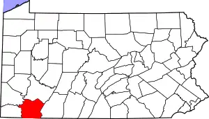 | |
| Boroughs | ||
| Townships | ||
| CDPs | ||
| Unincorporated communities |
| |
| Footnotes | ‡This populated place also has portions in an adjacent county or counties | |
| ||