Fayette City, Pennsylvania
Fayette City is a borough in Fayette County, Pennsylvania, United States. The population was 596 at the 2010 census,[3] down from 714 at the 2000 census. It is served by the Belle Vernon Area School District. Some buildings in the town date to before 1820.[4]
Fayette City, Pennsylvania | |
|---|---|
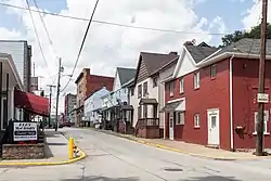 300 block of Main Street | |
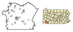 Location of Fayette City in Fayette County, Pennsylvania. | |
 Fayette City Location in Pennsylvania  Fayette City Fayette City (the United States) | |
| Coordinates: 40°6′2″N 79°50′20″W | |
| Country | United States |
| State | Pennsylvania |
| County | Fayette |
| Established | 1806 |
| Government | |
| • Mayor | Herbert Vargo Jr. |
| Area | |
| • Total | 0.28 sq mi (0.73 km2) |
| • Land | 0.22 sq mi (0.57 km2) |
| • Water | 0.06 sq mi (0.16 km2) |
| Elevation | 770 ft (230 m) |
| Population (2010) | |
| • Total | 596 |
| • Estimate (2019)[2] | 552 |
| • Density | 2,486.49/sq mi (960.88/km2) |
| Time zone | UTC-4 (EST) |
| • Summer (DST) | UTC-5 (EDT) |
| Area code(s) | 724 |
Like many towns around it, Fayette City has been home to many coal miners supporting the coal industry in the region.[5] It was the site of the Naomi Mine explosion, December 7, 1907. It was also the location of an explosion in the Apollo Mine in January 1926 [6]
Geography
Fayette City is located in northwestern Fayette County at 40°6′2″N 79°50′20″W (40.100647, -79.838913).[7] It sits on the east bank of the Monongahela River, which forms the border with Washington County. The borough of Allenport is directly across the river, but the closest river crossing is the I-70 bridge 3 miles (5 km) north at Belle Vernon. Pennsylvania Route 201 passes through Fayette City as Main Street (northbound) and Second Street (southbound). Uniontown, the Fayette County seat, is 17 miles (27 km) to the southeast via PA 201 and PA 51.
According to the United States Census Bureau, the borough has a total area of 0.25 square miles (0.66 km2), of which 0.19 square miles (0.50 km2) is land and 0.06 square miles (0.16 km2), or 24.33%, is water.[3]
Fayette City's low elevation and location along the Monongahela River make it susceptible to flooding after heavy rains. Lamb Lick Run and Downers Run enter the Monongahela within the borough's boundaries.
Demographics
| Historical population | |||
|---|---|---|---|
| Census | Pop. | %± | |
| 1840 | 411 | — | |
| 1850 | 972 | 136.5% | |
| 1860 | 820 | −15.6% | |
| 1870 | 889 | 8.4% | |
| 1880 | 867 | −2.5% | |
| 1890 | 931 | 7.4% | |
| 1900 | 1,595 | 71.3% | |
| 1910 | 2,005 | 25.7% | |
| 1920 | 2,018 | 0.6% | |
| 1930 | 1,594 | −21.0% | |
| 1940 | 1,598 | 0.3% | |
| 1950 | 1,404 | −12.1% | |
| 1960 | 1,159 | −17.5% | |
| 1970 | 968 | −16.5% | |
| 1980 | 788 | −18.6% | |
| 1990 | 713 | −9.5% | |
| 2000 | 714 | 0.1% | |
| 2010 | 596 | −16.5% | |
| 2019 (est.) | 552 | [2] | −7.4% |
| Sources:[8][9][10] | |||
As of the census[9] of 2000, there were 714 people, 286 households, and 193 families residing in the borough. The population density was 2,769.2 people per square mile (1,060.3/km²). There were 321 housing units at an average density of 1,245.0 per square mile (476.7/km²). The racial makeup of the borough was 99.30% White, 0.14% African American, and 0.56% from two or more races. Hispanic or Latino of any race were 0.14% of the population.
There were 286 households, out of which 33.2% had children under the age of 18 living with them, 45.5% were married couples living together, 15.4% had a female householder with no husband present, and 32.5% were non-families. 30.1% of all households were made up of individuals, and 16.8% had someone living alone who was 65 years of age or older. The average household size was 2.50 and the average family size was 3.11.
In the borough the population was spread out, with 27.3% under the age of 18, 7.7% from 18 to 24, 29.3% from 25 to 44, 20.2% from 45 to 64, and 15.5% who were 65 years of age or older. The median age was 38 years. For every 100 females, there were 88.9 males. For every 100 females age 18 and over, there were 85.4 males.
The median income for a household in the borough was $29,375, and the median income for a family was $38,542. Males had a median income of $35,357 versus $23,250 for females. The per capita income for the borough was $13,058. About 20.2% of families and 26.1% of the population were below the poverty line, including 38.8% of those under age 18 and 17.3% of those age 65 or over.
Notable people
- Jim Russell, baseball player.
References
- "2019 U.S. Gazetteer Files". United States Census Bureau. Retrieved July 28, 2020.
- "Population and Housing Unit Estimates". United States Census Bureau. May 24, 2020. Retrieved May 27, 2020.
- "Geographic Identifiers: 2010 Census Summary File 1 (G001), Fayette City borough, Pennsylvania". American FactFinder. U.S. Census Bureau. Archived from the original on February 13, 2020. Retrieved July 7, 2016.
- "Mon Valley Photo Tour, Part I: Fayette City".
- "Archived copy". Archived from the original on 2011-07-07. Retrieved 2008-12-07.CS1 maint: archived copy as title (link)
- "Fayette Co PA Disasters".
- "US Gazetteer files: 2010, 2000, and 1990". United States Census Bureau. 2011-02-12. Retrieved 2011-04-23.
- "Census of Population and Housing". U.S. Census Bureau. Retrieved 11 December 2013.
- "U.S. Census website". United States Census Bureau. Retrieved 2008-01-31.
- "Incorporated Places and Minor Civil Divisions Datasets: Subcounty Resident Population Estimates: April 1, 2010 to July 1, 2012". Population Estimates. U.S. Census Bureau. Archived from the original on June 11, 2013. Retrieved 11 December 2013.
| Wikimedia Commons has media related to Fayette City, Pennsylvania. |
| Counties |  Map of the Pittsburgh Tri-State with green counties in the metropolitan area and yellow counties in the combined area | |
|---|---|---|
| Major cities | ||
| Cities and towns 15k–50k (in 2010) | ||
| Airports | ||
| Topics | ||
| ||
Municipalities and communities of Fayette County, Pennsylvania, United States | ||
|---|---|---|
| Cities |  | |
| Boroughs | ||
| Townships | ||
| CDPs | ||
| Unincorporated communities |
| |
| Footnotes | ‡This populated place also has portions in an adjacent county or counties | |
| ||
| Authority control |
|---|