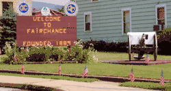
Fairchance, Pennsylvania
Fairchance is a borough in Fayette County, Pennsylvania, United States. The population was 1,975 at the 2010 census,[3] down from 2,174 at the 2000 census. It is served by the Albert Gallatin Area School District.
Fairchance, Pennsylvania | |
|---|---|
 | |
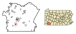 Location of Fairchance in Fayette County, Pennsylvania. | |
 Fairchance Location in Pennsylvania  Fairchance Fairchance (the United States) | |
| Coordinates: 39°49′26″N 79°45′17″W | |
| Country | United States |
| State | Pennsylvania |
| County | Fayette |
| Established | 1889 |
| Government | |
| • Mayor | Tom Tanner |
| Area | |
| • Total | 1.19 sq mi (3.09 km2) |
| • Land | 1.19 sq mi (3.09 km2) |
| • Water | 0.00 sq mi (0.00 km2) |
| Population (2010) | |
| • Total | 1,975 |
| • Estimate (2019)[2] | 1,886 |
| • Density | 1,580.89/sq mi (610.61/km2) |
| Time zone | UTC-4 (EST) |
| • Summer (DST) | UTC-5 (EDT) |
| Area code(s) | 724, 878 |
Geography
Fairchance is located in south-central Fayette County at 39°49′26″N 79°45′17″W (39.823970, -79.754800).[4] It sits at the western base of Chestnut Ridge, the westernmost major ridge of the Appalachian Mountains in this area.
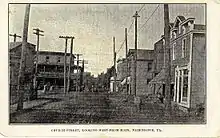
Pennsylvania Route 43, the Mon–Fayette Expressway, passes just west of the borough limits, with access from Exit 8 (Big 6 Road). The toll highway leads north 7 miles (11 km) to Uniontown, the county seat, and southwest 19 miles (31 km) to Morgantown, West Virginia. Pennsylvania Route 857 passes through the center of Fairchance as Morgantown Street.
According to the United States Census Bureau, the borough has a total area of 1.20 square miles (3.11 km2), all of it land.[3]
Demographics
| Historical population | |||
|---|---|---|---|
| Census | Pop. | %± | |
| 1890 | 1,092 | — | |
| 1900 | 1,219 | 11.6% | |
| 1910 | 1,760 | 44.4% | |
| 1920 | 2,124 | 20.7% | |
| 1930 | 1,804 | −15.1% | |
| 1940 | 1,855 | 2.8% | |
| 1950 | 2,091 | 12.7% | |
| 1960 | 2,120 | 1.4% | |
| 1970 | 1,906 | −10.1% | |
| 1980 | 2,106 | 10.5% | |
| 1990 | 1,918 | −8.9% | |
| 2000 | 2,174 | 13.3% | |
| 2010 | 1,975 | −9.2% | |
| 2019 (est.) | 1,886 | [2] | −4.5% |
| Sources:[5][6][7] | |||
As of the census[6] of 2000, there were 2,174 people, 871 households, and 594 families residing in the borough. The population density was 1,797.1 people per square mile (693.7/km2). There were 932 housing units at an average density of 770.4 per square mile (297.4/km2). The racial makeup of the borough was 95.81% White, 2.76% African American, 0.09% Native American, 0.09% Asian, and 1.24% from two or more races. Hispanic or Latino of any race were 0.51% of the population.
There were 871 households, out of which 29.3% had children under the age of 18 living with them, 50.7% were married couples living together, 13.0% had a female householder with no husband present, and 31.7% were non-families. 27.3% of all households were made up of individuals, and 14.4% had someone living alone who was 65 years of age or older. The average household size was 2.47 and the average family size was 3.00.
In the borough the population was spread out, with 23.8% under the age of 18, 8.8% from 18 to 24, 27.3% from 25 to 44, 22.7% from 45 to 64, and 17.4% who were 65 years of age or older. The median age was 38 years. For every 100 females, there were 87.6 males. For every 100 females age 18 and over, there were 82.1 males.
The median income for a household in the borough was $26,840, and the median income for a family was $33,611. Males had a median income of $27,625 versus $20,750 for females. The per capita income for the borough was $14,021. About 12.0% of families and 16.5% of the population were below the poverty line, including 19.1% of those under age 18 and none of those age 65 or over.
Fairchance is the hometown of Mark "Stoy" McCahill, the founder of the "Peach St. Zoo"
Name
Many townspeople state that Fairchance got its name in the early days of transportation. The story goes that travelers from Morgantown, West Virginia, who made it to the borough by 4:00 P.M. had a "fair chance" of making it to Uniontown before sundown. Another explanation cited in the book Fairchance Through the Years, compiled by the Fairchance Centennial History Committee, is that Fidelio H. Oliphant, who operated iron furnaces in the area, went to a bank in Uniontown to borrow money with the assurance that he had a "fair chance" of paying it back.
References
- "2019 U.S. Gazetteer Files". United States Census Bureau. Retrieved July 28, 2020.
- "Population and Housing Unit Estimates". United States Census Bureau. May 24, 2020. Retrieved May 27, 2020.
- "Geographic Identifiers: 2010 Census Summary File 1 (G001), Fairchance borough, Pennsylvania". American FactFinder. U.S. Census Bureau. Archived from the original on February 13, 2020. Retrieved July 7, 2016.
- "US Gazetteer files: 2010, 2000, and 1990". United States Census Bureau. 2011-02-12. Retrieved 2011-04-23.
- "Census of Population and Housing". U.S. Census Bureau. Retrieved 11 December 2013.
- "U.S. Census website". United States Census Bureau. Retrieved 2008-01-31.
- "Incorporated Places and Minor Civil Divisions Datasets: Subcounty Resident Population Estimates: April 1, 2010 to July 1, 2012". Population Estimates. U.S. Census Bureau. Archived from the original on 11 June 2013. Retrieved 11 December 2013.
| Counties |  Map of the Pittsburgh Tri-State with green counties in the metropolitan area and yellow counties in the combined area | |
|---|---|---|
| Major cities | ||
| Cities and towns 15k–50k (in 2010) | ||
| Airports | ||
| Topics | ||
| ||
Municipalities and communities of Fayette County, Pennsylvania, United States | ||
|---|---|---|
| Cities |  | |
| Boroughs | ||
| Townships | ||
| CDPs | ||
| Unincorporated communities |
| |
| Footnotes | ‡This populated place also has portions in an adjacent county or counties | |
| ||