Sudbury District
The Sudbury District is a district in Northeastern Ontario in the Canadian province of Ontario. It was created in 1894 from townships of eastern Algoma District and west Nipissing District.
Sudbury District
District de Sudbury | |
|---|---|
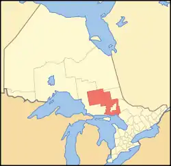 Location of Sudbury District in Ontario | |
| Coordinates: 47°30′N 82°00′W | |
| Country | |
| Province | |
| Region | Northeastern Ontario |
| Created | 1907 |
| Government | |
| • MPs | Marc Serré, Carol Hughes |
| • MPPs | Michael Mantha, France Gélinas |
| Area | |
| • Land | 40,205.41 km2 (15,523.40 sq mi) |
| Population (2016)[2] | |
| • Total | 21,546 |
| • Density | 0.5/km2 (1/sq mi) |
| Time zone | UTC-5 (Eastern (EST)) |
| • Summer (DST) | UTC-4 (EDT) |
| Area code(s) | 705 |
| Seat | Espanola |
The overwhelming majority of the district (about 92%) is unincorporated and part of Unorganized North Sudbury District. With the exception of Chapleau, all of the district's incorporated municipalities are found in the area immediately surrounding the city of Greater Sudbury to the west, east and south. North of the Greater Sudbury area, the district is sparsely populated; between Sudbury and Chapleau, only unincorporated settlements, ghost towns and small First Nations reserves are found.
Status of Greater Sudbury
Because the districts of Northern Ontario are unincorporated territorial divisions, unlike the counties or regional municipalities of Southern Ontario, the city of Greater Sudbury is legally defined as part of the district in the geographic sense.
Politically, however, the district and the city are considered two distinct census divisions and two distinct jurisdictions for provincial government services. The district's social services board — which has offices in the district seat of Espanola, as well as satellite offices in several other communities in the district — instead shares its jurisdictional area with the neighbouring Manitoulin District, whereas equivalent services in Greater Sudbury, which has the status of a single-tier municipality, are provided directly from the city.
With the city included, the district would have had a population of 181,572 in the 2011 census.
Subdivisions
Unorganized areas
Local services areas in Unorganized Sudbury include:
First Nations reserves
- Chapleau 74A
- Chapleau 75
- Duck Lake
- Mattagami
- Mountbatten
- Whitefish Lake
- Whitefish River (boundaries include parts of both Sudbury and Manitoulin Districts)
Demographics
| Canada census – Sudbury District community profile | |||
|---|---|---|---|
| 2016 | 2011 | 2006 | |
| Population: | 21,546 (1.7% from 2011) | 21,196 (-3.0% from 2006) | 21,392 (-6.6% from 2001) |
| Land area: | 40,205.41 km2 (15,523.40 sq mi) | 38,504.53 km2 (14,866.68 sq mi) | |
| Population density: | 0.5/km2 (1.3/sq mi) | 0.6/km2 (1.6/sq mi) | |
| Median age: | 45.0 (M: 45.0, F: 44.9) | ||
| Total private dwellings: | 12,557 | 11,918 | 12,006 |
| Median household income: | |||
| Notes: 2006 population adjusted for 2011 boundaries is 21,851. – References: 2016[2] 2011[1] 2006[3] earlier[4] | |||
The city and the district are considered two distinct census divisions by Statistics Canada. Therefore, the table above does not include the data for the City of Greater Sudbury.
Provincial highways
The Sudbury District is served by Trans-Canada Highways 17, which leads from the community of Walford (Sables-Spanish Rivers) in the west to the community of Warren (Markstay-Warren) in the east, and 69, which enters the district at French River and exits at the southern boundary of Greater Sudbury.
The Ontario government is converting Highway 69 to a freeway. Construction, and renumbering as Highway 400, are expected to be complete by 2021.
Other primary provincial highways in the district are:
- Highway 6, which extends from Highway 17 south to Whitefish Falls, where it enters the Manitoulin District,
- Highway 64, which runs from Highway 69 east and north through the Municipality of French River, and enters the Nipissing District at Mashkinonje Provincial Park,
- Highway 101, which extends from the boundary of Algoma District, west of Chapleau, to the boundary of Cochrane District, just outside Timmins,
- Highway 129, which runs from Highway 101 to the boundary of Algoma District south of Chapleau,
- Highway 144, which runs from the northwestern city limits of Greater Sudbury north to the boundary of Timiskaming District, just outside Timmins.
The Sudbury District also has a number of secondary provincial highways, which are the analogue in a district to county or municipal roads in Southern Ontario. They are important connections to the communities they serve, but are not significant routes for through traffic. The secondary highways are:
- Highway 528, connecting the community of Wolseley Bay (French River) to Highway 64,
- Highway 528A, which provides access to the south side of the water body at Wolseley Bay,
- Highway 535, connecting Highway 64 at Noëlville (French River) to Highway 17 at Hagar (St. Charles),
- Highway 553, extending north from the community of Massey (Sables-Spanish Rivers),
- Highway 560, which runs from Highway 144 to the boundary of Timiskaming District, through Shining Tree,
- Highway 560A, which connects Westree to Highway 560,
- Highway 607, which runs from Bigwood (French River) to Highway 64,
- Highway 607A, which provides road access to the French River,
- Highway 637, which runs from Highway 69 to the community of Killarney,
- Highway 661, which connects the community of Gogama to Highway 144.
See also Sultan Industrial Road.
Provincial parks
- Biscotasi Lake
- Chapleau-Nemegosenda River
- Chiniguchi River Waterway
- Chutes
- Esker Provincial Park
- Five Mile Lake
- French River
- Halfway Lake
- Ivanhoe Lake
- Killarney
- Killarney Lakelands and Headwaters
- La Cloche
- La Motte
- Lady Evelyn-Smoothwater
- Mashkinonje
- Missinaibi
- Mississagi River
- Obabika River
- The Shoals
- Solace
- Sturgeon River
- Wakami Lake
- Windy Lake
See also
References
- "2011 Community Profiles". 2011 Canadian Census. Statistics Canada. July 5, 2013. Retrieved 2012-03-19.
- "2016 Community Profiles". 2016 Canadian Census. Statistics Canada. February 21, 2017.
- "2006 Community Profiles". 2006 Canadian Census. Statistics Canada. March 30, 2011. Retrieved 2012-03-19.
- "2001 Community Profiles". 2001 Canadian Census. Statistics Canada. February 17, 2012.
External links
| Wikimedia Commons has media related to Sudbury District, Ontario. |
Places adjacent to Sudbury District | |
|---|---|
| Towns | 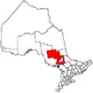 | |
|---|---|---|
| Townships | ||
| First Nations | ||
| Indian reserves | ||
| Unorganized area | ||
| Local services boards | ||
| ||
| Regions | |
|---|---|
| Counties | |
| Districts | |
| Regional municipalities | |
| Single-tier municipalities | |
| Separated municipalities | |
| |