Algoma District
Algoma District is a district and census division in Northeastern Ontario in the Canadian province of Ontario.
Algoma District
District d'Algoma | |
|---|---|
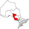
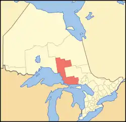 Location of Algoma District in Ontario | |
| Coordinates: 48°00′N 84°30′W | |
| Country | |
| Province | |
| Region | Northeastern Ontario |
| Created | 1858 |
| Area | |
| • Land | 48,814.88 km2 (18,847.53 sq mi) |
| Population (2016)[1] | |
| • Total | 114,094 |
| • Density | 2.3/km2 (6/sq mi) |
| Time zone | UTC-5 (EST) |
| • Summer (DST) | UTC-4 (EDT) |
| Area code(s) | 705 |
| Seat | Sault Ste. Marie |
The name was created by an American ethnologist, Henry Rowe Schoolcraft (1793-1864), who was appointed Indian agent to the Ojibway in Sault Ste. Marie region in 1822. "Al" is derived from Algonquin, while "goma" is a variant of gomee, meaning lake or water.[2]
History
Algoma was created by proclamation in 1858[3] as a provisional judicial district of the Province of Canada comprising territory north of the French River as far west as Pigeon River (Minnesota-Ontario), including all Canadian islands in Lakes Huron and Superior. The authorizing act of the Legislative Assembly of the Province of Canada was An Act to provide for the Administration of Justice in the unorganized Tracts of Country within the limits of this Province (known by its short title as The Temporary Judicial Districts Act, 1857).
The district seat has been Sault Ste. Marie since 1858.
As the population grew and the northern and northwestern boundaries of Ontario were determined by the Judicial Committee of the Privy Council, Algoma shrank. Other districts were created from it by the provincial government of Ontario:
- Thunder Bay District in 1871
- Manitoulin District in 1888
- Sudbury District in 1894
- Timiskaming District in 1912
The rugged scenery of this region has inspired works by Canadian artists, particularly the Group of Seven. They rented a boxcar from the Algoma Central Railway to travel on excursions through this region.
Subdivisions
Communities within these subdivisions are added in parentheses.
Cities
| Name of City | Population | Ref. |
|---|---|---|
| Elliot Lake | 10,743 | |
| Sault Ste. Marie | 73,368 |
Towns
| Name of Town | Population | Ref. |
|---|---|---|
| Blind River | 3,472 | |
| Bruce Mines | 566 | |
| Spanish | 696 | |
| Thessalon | 1,279 |
Townships
| Name of Township | Population | Ref. |
|---|---|---|
| Dubreuilville | 635 | |
| Hilton | 261 | |
| Hornepayne | 1,050 | |
| Huron Shores (Iron Bridge, Sowerby, Little Rapids, Dean Lake) | 1,723 | |
| Jocelyn (Kentvale) | 237 | |
| Johnson (Desbarats) | 750 | |
| Laird | 1,057 | |
| Macdonald, Meredith and Aberdeen Additional (Echo Bay, Bar River, Sylvan Valley) | 1,609 | |
| The North Shore (Spragge, Serpent River, Algoma Mills) | 509 | |
| Plummer Additional | 650 | |
| Prince | 1,031 | |
| St. Joseph (Richard's Landing) | 1,240 | |
| Tarbutt | 396 | |
| Wawa (Michipicoten, Michipicoten River) | 2,975 | |
| White River | 607 |
Villages
| Name of Village | Population | Ref. |
|---|---|---|
| Hilton Beach | 145 |
Reserves
| Name of Reserve | Population | Ref. |
|---|---|---|
| Garden River 14 | 1,170 | |
| Goulais Bay 15A | 82 | |
| Gros Cap 49 | 68 | |
| Gros Cap Indian Village 49A | N/A | |
| Missanabie 62 | N/A | |
| Mississauga First Nation #8 | 390 | |
| Obadjiwan 15E | N/A | |
| Rankin Location 15D | 566 | |
| Sagamok | 1,036 | |
| Serpent River 7 | 373 | |
| Thessalon 12 | 108 | |
| Whitefish Island | N/A |
Unorganized areas
Demographics
| Canada census – Algoma District community profile | |||
|---|---|---|---|
| 2016 | 2011 | 2006 | |
| Population: | 114094 (-1.5% from 2011) | 115870 (-1.4% from 2006) | 117461 (-0.9% from 2001) |
| Land area: | 48,814.88 km2 (18,847.53 sq mi) | 48,810.68 km2 (18,845.91 sq mi) | 48,734.66 km2 (18,816.56 sq mi) |
| Population density: | 2.3/km2 (6.0/sq mi) | 2.4/km2 (6.2/sq mi) | 2.4/km2 (6.2/sq mi) |
| Median age: | 45.0 (M: 44.4, F: 45.5) | ||
| Total private dwellings: | 60,324 | 59,149 | 58,742 |
| Median household income: | |||
| Notes: Excludes census data for one or more incompletely enumerated Indian reserves. – References: 2016[4] 2011[5] 2006[6] earlier[7] | |||
Highways
Secondary highways
Tertiary highways
- #821
Protected areas
|
|
Forests
In the Algoma section, the characteristic forest mixture consists of yellow birch, white spruce, balsam fir, sugar maple, hop-hornbeam, and eastern white cedar. Eastern white pine and occasional red pine (Pinus resinosa) dominate on the upper, steep south-facing slopes; white spruce, eastern white cedar, and balsam fir occupy the middle and lower slopes. A white spruce–balsam fir association, which usually includes white birch and black spruce, is prominent on the river terraces and adjoining flats in the northern part of the Section (Rowe 1972).[8]
Attractions
- Algoma Central Railway - Agawa Canyon (Algoma, Unorganized, North Part)
- Algoma University (Sault Ste. Marie)
- Fire Tower Lookout (Elliot Lake)
- Fort St. Joseph National Historic Site (St. Joseph)
- High Falls of the Michipicoten River (Wawa)
- Mount Dufour Ski Resort (Elliot Lake)
- Sault Ste. Marie Airport (Sault Ste. Marie)
- Sault Ste. Marie Canal (Sault Ste. Marie)
- Sault College (Sault Ste. Marie)
- Searchmont Ski Area
- Stone Ridge Golf Resort (Elliot Lake)
- Crimson Ridge Golf Course
- Batchawana Bay Provincial Park
- Hub Trail (hiking, bicycling, and cross-country ski trail through Sault Ste. Marie)
- Rocking On The River (Wandering-Elk Promotion & Productions), Concert Venue @ 135 Royer Rd., Blind River.
See also
References
- "Algoma District census profile". 2016 Census of Population. Statistics Canada. Retrieved 2017-02-08.
- Hamilton, William (1978). Canadian Place Names. Macmillan. p. 132. ISBN 0-7715-9754-1.
- Proclamation to take effect 1 May 1858, Canada Gazette (April 17, 1858), p. 676-677. New Proclamation to take effect 1 Oct 1859, Canada Gazette (Sept 10, 1859), p. 2226.
- "2016 Community Profiles". 2016 Canadian Census. Statistics Canada. February 21, 2017. Retrieved 2017-04-17.
- "2011 Community Profiles". 2011 Canadian Census. Statistics Canada. July 5, 2013. Retrieved 2012-03-19.
- "2006 Community Profiles". 2006 Canadian Census. Statistics Canada. March 30, 2011. Retrieved 2012-03-19.
- "2001 Community Profiles". 2001 Canadian Census. Statistics Canada. February 17, 2012.
- Rowe, J.S 1972. Forest regions of Canada. Can. Dep. Environ., Can. For. Serv., Ottawa ON, Publ. 1300. 172 p.
External links
| Wikimedia Commons has media related to Algoma District, Ontario. |
Places adjacent to Algoma District | |
|---|---|
| Regions | |
|---|---|
| Counties | |
| Districts | |
| Regional municipalities | |
| Single-tier municipalities | |
| Separated municipalities | |
| |