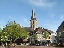
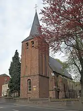
Straelen
Straelen (German pronunciation: [ˈʃtʁaːlən]) is a municipality in the district of Cleves, in North Rhine-Westphalia, Germany. It is located near the border with the Netherlands, approx. 10 km north-east of Venlo.
Straelen | |
|---|---|
 | |
 Coat of arms | |
Location of Straelen within Kleve district 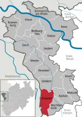 | |
 Straelen  Straelen | |
| Coordinates: 51°27′00″N 06°16′00″E | |
| Country | Germany |
| State | North Rhine-Westphalia |
| Admin. region | Düsseldorf |
| District | Kleve |
| Government | |
| • Mayor | Hans-Josef Linßen ((CDU)) |
| Area | |
| • Total | 74 km2 (29 sq mi) |
| Elevation | 35 m (115 ft) |
| Population (2019-12-31)[1] | |
| • Total | 16,257 |
| • Density | 220/km2 (570/sq mi) |
| Time zone | UTC+01:00 (CET) |
| • Summer (DST) | UTC+02:00 (CEST) |
| Postal codes | 47638 |
| Dialling codes | 02834 & 02839 |
| Vehicle registration | KLE |
| Website | www.straelen.de |
History
![]() County of Guelders 1118–1339
County of Guelders 1118–1339
![]() Duchy of Guelders 1339–1393
Duchy of Guelders 1339–1393
![]() Duchy of Jülich 1393–1423
Duchy of Jülich 1393–1423
![]() Duchy of Guelders 1423–1543
Duchy of Guelders 1423–1543
![]() Habsburg Netherlands 1543–1556
Habsburg Netherlands 1543–1556
![]() Spanish Netherlands 1556–1632
Spanish Netherlands 1556–1632
![]() Dutch Republic 1632–1635
Dutch Republic 1632–1635
![]() Spanish Netherlands 1635–1713
Spanish Netherlands 1635–1713
![]() Kingdom of Prussia 1713–1794
Kingdom of Prussia 1713–1794
![]() French Republic 1794–1804
French Republic 1794–1804
![]() French Empire 1804–1814
French Empire 1804–1814
![]() Kingdom of Prussia 1815–1871
Kingdom of Prussia 1815–1871
![]() German Empire 1871–1918
German Empire 1871–1918
![]() Weimar Republic 1919–1933
Weimar Republic 1919–1933
![]() Nazi Germany 1933–1945
Nazi Germany 1933–1945
![]() Allied-occupied Germany 1945–1949
Allied-occupied Germany 1945–1949
![]() West Germany 1949–1990
West Germany 1949–1990
![]() Germany 1990–present
Germany 1990–present
Straelen was first mentioned in Latin as Strala in 1063.
References
- "Bevölkerung der Gemeinden Nordrhein-Westfalens am 31. Dezember 2019" (in German). Landesbetrieb Information und Technik NRW. Retrieved 17 June 2020.
External links
- Official website
 (in German)
Towns and municipalities in Kleve (district) | ||
|---|---|---|
Coat of Arms of Kleve district | ||
| Authority control |
|---|