Success, New Hampshire
Success is an unincorporated township located in Coös County, New Hampshire, United States. It is located directly to the east of the city of Berlin, New Hampshire, and borders on the state of Maine. Success is part of the Berlin, NH–VT Micropolitan Statistical Area.
Success, New Hampshire | |
|---|---|
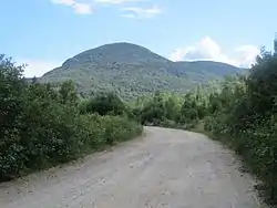 North Bald Cap as seen from Success Pond Road | |
 Location in Coös County, New Hampshire | |
| Coordinates: 44°31′38″N 71°04′47″W | |
| Country | United States |
| State | New Hampshire |
| County | Coös |
| Area | |
| • Total | 57.0 sq mi (147.6 km2) |
| • Land | 56.5 sq mi (146.3 km2) |
| • Water | 0.5 sq mi (1.3 km2) 0.91% |
| Elevation | 3,565 ft (1,087 m) |
| Population (2010) | |
| • Total | 0 |
| Time zone | UTC-5 (Eastern) |
| • Summer (DST) | UTC-4 (Eastern) |
| Area code(s) | 603 |
As of the 2010 census, the township had a population of zero. There are some seasonal homes, cabins, and cottages mainly located around Success Pond, which gives the township a small seasonal population, although none of these homes are primary residences.
As of 2005, one of the larger landowners in Success is the Androscoggin Valley Regional Refuse Disposal District.
History
Success was granted in 1773 and contained about 90,472 acres (366.1 km2). The grantees were Benjamin Mackay and about seventy others.
The state of New Hampshire requires a nearby incorporated town to exercise the responsibilities that would fall to the Town of Success if it should be incorporated. Some towns in the state bearing such responsibility have sought to be relieved of it.
Blanchard and Twitchell Railroad
A railroad was built by Blanchard and Twitchell Company in 1892 from the Boston and Maine Railroad in Berlin, New Hampshire, through the aboriginal forests to Success Pond in the northeast corner of the township. Six locomotives transported lumber and logs to Berlin sawmills over the 26-mile (42 km) railway. Most of the Success township forests were gone within a decade, but the railway operated after 1904 as the George W. Blanchard and Sons Company Railroad, as Cassius M. C. Twitchell had sold his interest in the business in 1901. Boston and Maine kept 1,600 feet (490 m) of interchange track in service when the remainder of the railroad was dismantled in 1907.[1]
Geography
According to the United States Census Bureau, the township has a total area of 57.0 square miles (147.6 km2), of which 56.5 square miles (146.3 km2) is land and 0.5 square miles (1.3 km2), or 0.91%, is water.[2]
The highest point in the township is the summit of Mount Success, a peak in the Mahoosuc Range with an elevation of 3,565 feet (1,087 m) above sea level.
Demographics
| Historical population | |||
|---|---|---|---|
| Census | Pop. | %± | |
| 1830 | 14 | — | |
| 1860 | 11 | — | |
| 1870 | 5 | −54.5% | |
| 1900 | 220 | — | |
| 1920 | 8 | — | |
| 1930 | 0 | −100.0% | |
| 1940 | 1 | — | |
| 1950 | 0 | −100.0% | |
| 1960 | 0 | — | |
| 1970 | 2 | — | |
| 1980 | 0 | −100.0% | |
| 1990 | 0 | — | |
| 2000 | 2 | — | |
| 2010 | 0 | −100.0% | |
| 2015 (est.) | 0 | [3] | |
| U.S. Decennial Census[4] | |||
As of the 2010 census,[5] there were no people living in the township, although there are a number of summer homes mainly on the shores around Success Pond.[5]
References
- "Berlin - The City That Trees Built: Turning Land and Lumber Into Neighborhoods" (PDF). Berlin & Coos County Historical Society. Retrieved November 1, 2020.
- "Geographic Identifiers: 2010 Demographic Profile Data (G001) - Success township, New Hampshire". United States Census Bureau. Retrieved November 9, 2011.
- "Annual Estimates of the Resident Population for Incorporated Places: April 1, 2010 to July 1, 2015". Archived from the original on June 2, 2016. Retrieved July 2, 2016.
- "Census of Population and Housing". Census.gov. Retrieved June 4, 2016.
- United States Census Bureau, American FactFinder, 2010 Census figures. Retrieved March 23, 2011.
Places adjacent to Success, New Hampshire | |
|---|---|
Municipalities and communities of Coös County, New Hampshire, United States | ||
|---|---|---|
| City | 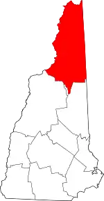 Map of New Hampshire highlighting Coos County | |
| Towns | ||
| Townships |
| |
| CDPs | ||
| Other communities | ||
| ||