Dummer, New Hampshire
Dummer is a town in Coos County, New Hampshire, United States. The population was 304 at the 2010 census.[1] It is part of the Berlin, NH–VT micropolitan statistical area. Dummer is home to the Pontook Reservoir, popular with canoeists, kayakers and birdwatchers. In the western part of Dummer lies the village of Paris.
Dummer, New Hampshire | |
|---|---|
Town | |
 Pontook Reservoir | |
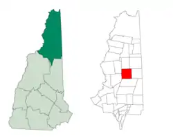 Location in Coos County, New Hampshire | |
| Coordinates: 44°36′38″N 71°12′03″W | |
| Country | United States |
| State | New Hampshire |
| County | Coos |
| Incorporated | 1848 |
| Government | |
| • Board of Selectmen | Richard Ouellette, Chair David Dubey Christopher Holt |
| Area | |
| • Total | 49.5 sq mi (128.1 km2) |
| • Land | 48.2 sq mi (124.9 km2) |
| • Water | 1.2 sq mi (3.1 km2) 2.43% |
| Elevation | 1,175 ft (358 m) |
| Population (2010) | |
| • Total | 304 |
| • Density | 6.1/sq mi (2.4/km2) |
| Time zone | UTC-5 (Eastern) |
| • Summer (DST) | UTC-4 (Eastern) |
| ZIP code | 03588 |
| Area code(s) | 603 |
| FIPS code | 33-19300 |
| GNIS feature ID | 0873582 |
| Website | dummernh |
History
The town was granted on March 8, 1773 by Governor John Wentworth to a group of wealthy Portsmouth investors, including his father, Mark Hunking Wentworth, Nathaniel Haven and others.[2] He named it after Massachusetts Governor William Dummer,[3] who successfully defended the eastern English provinces from the French and Indians in Dummer's War.[4] But the town remained unsettled until 1812 when William Leighton arrived from Farmington with his family. Dummer was incorporated by the General Court on December 19, 1848.[5]

Mountainous terrain and sterility of the soil prevented cultivation. But the region had forests, and the Upper Ammonoosuc River provided water power for mills. There were two sawmills operating by 1859, with a considerable trade in timber.[2] Log drives on the Androscoggin River supplied the papermills downstream in Berlin. Pontook Dam, which created Pontook Reservoir, was reconstructed in the mid-1980s to generate hydroelectric power.
Geography
According to the United States Census Bureau, the town has a total area of 49.5 square miles (128 km2), of which 48.2 square miles (125 km2) is land and 1.2 square miles (3.1 km2) is water, comprising 2.43% of the town.[6] The highest point in Dummer is the summit of Cow Mountain, at 2,289 feet (698 m) above sea level. Roughly the western third of Dummer lies within the Connecticut River watershed, where it is drained by the Upper Ammonoosuc River, with the eastern two-thirds in the Androscoggin River watershed.[7] The former community of Paris is in the western part of town, along Phillips Brook.
Dummer is bordered by Milan to the south, Errol and Millsfield to the north, Cambridge to the east, and Odell and Stark to the west.
Dummer is crossed by New Hampshire Route 16.
Demographics
| Historical population | |||
|---|---|---|---|
| Census | Pop. | %± | |
| 1810 | 7 | — | |
| 1820 | 27 | 285.7% | |
| 1830 | 65 | 140.7% | |
| 1840 | 57 | −12.3% | |
| 1850 | 171 | 200.0% | |
| 1860 | 289 | 69.0% | |
| 1870 | 317 | 9.7% | |
| 1880 | 464 | 46.4% | |
| 1890 | 455 | −1.9% | |
| 1900 | 349 | −23.3% | |
| 1910 | 292 | −16.3% | |
| 1920 | 266 | −8.9% | |
| 1930 | 298 | 12.0% | |
| 1940 | 274 | −8.1% | |
| 1950 | 229 | −16.4% | |
| 1960 | 202 | −11.8% | |
| 1970 | 225 | 11.4% | |
| 1980 | 390 | 73.3% | |
| 1990 | 327 | −16.2% | |
| 2000 | 309 | −5.5% | |
| 2010 | 304 | −1.6% | |
| 2017 (est.) | 284 | [8] | −6.6% |
| U.S. Decennial Census[9] | |||
As of the census[10] of 2000, there were 309 people, 128 households, and 102 families living in the town. The population density was 6.5 people per square mile (2.5/km2). There were 252 housing units at an average density of 5.3 per square mile (2.0/km2). The racial makeup of the town was 98.71% White, 0.32% Asian, and 0.97% from two or more races.
There were 128 households, out of which 30.5% had children under the age of 18 living with them, 64.8% were married couples living together, 10.9% had a female householder with no husband present, and 20.3% were non-families. 19.5% of all households were made up of individuals, and 5.5% had someone living alone who was 65 years of age or older. The average household size was 2.40 and the average family size was 2.73.
In the town, the population was spread out, with 24.3% under the age of 18, 3.9% from 18 to 24, 28.5% from 25 to 44, 30.4% from 45 to 64, and 12.9% who were 65 years of age or older. The median age was 42 years. For every 100 females, there were 103.3 males. For every 100 females age 18 and over, there were 100.0 males.
The median income for a household in the town was $32,750, and the median income for a family was $42,708. Males had a median income of $29,286 versus $22,083 for females. The per capita income for the town was $16,754. About 4.6% of families and 6.7% of the population were below the poverty line, including 2.4% of those under the age of eighteen and 10.0% of those 65 or over.
References
- United States Census Bureau, U.S. Census website, 2010 Census figures. Retrieved March 23, 2011.
- Austin J. Coolidge & John B. Mansfield, A History and Description of New England; Boston, Massachusetts 1859
- Gannett, Henry (1905). The Origin of Certain Place Names in the United States. Govt. Print. Off. pp. 110.
- New Hampshire Economic and Labor Market Information Bureau Profile
- "Archived copy". Archived from the original on 2008-08-21. Retrieved 2009-11-13.CS1 maint: archived copy as title (link)
- "Geographic Identifiers: 2010 Demographic Profile Data (G001) - Dummer town, New Hampshire". United States Census Bureau. Retrieved November 8, 2011.
- Foster, Debra H.; Batorfalvy, Tatianna N.; Medalie, Laura (1995). Water Use in New Hampshire: An Activities Guide for Teachers. U.S. Department of the Interior and U.S. Geological Survey.
- "Annual Estimates of the Resident Population: April 1, 2010 to July 1, 2017 (PEPANNRES): Minor Civil Divisions – New Hampshire". Archived from the original on February 13, 2020. Retrieved November 14, 2018.
- "Census of Population and Housing". Census.gov. Retrieved June 4, 2016.
- "U.S. Census website". United States Census Bureau. Retrieved 2008-01-31.
External links
Places adjacent to Dummer, New Hampshire | |
|---|---|
Municipalities and communities of Coös County, New Hampshire, United States | ||
|---|---|---|
| City |  Map of New Hampshire highlighting Coos County | |
| Towns | ||
| Townships |
| |
| CDPs | ||
| Other communities | ||
| ||