Stewartstown, New Hampshire
Stewartstown is a town in Coos County, New Hampshire, United States. The population was 1,004 at the 2010 census.[1] It includes the village of West Stewartstown and is part of the Berlin, NH–VT Micropolitan Statistical Area.
Stewartstown, New Hampshire | |
|---|---|
Town | |
 West Stewartstown | |
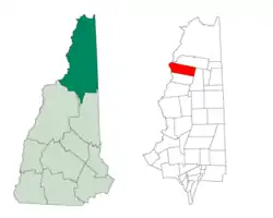 Location in Coos County, New Hampshire | |
| Coordinates: 45°00′22″N 71°30′28″W | |
| Country | United States |
| State | New Hampshire |
| County | Coos |
| Incorporated | 1795 |
| Villages | West Stewartstown Stewartstown Hollow |
| Area | |
| • Total | 46.8 sq mi (121.2 km2) |
| • Land | 46.2 sq mi (119.7 km2) |
| • Water | 0.6 sq mi (1.5 km2) 1.23% |
| Elevation | 1,181 ft (360 m) |
| Population (2010) | |
| • Total | 1,004 |
| • Density | 21/sq mi (8.3/km2) |
| Time zone | UTC-5 (Eastern) |
| • Summer (DST) | UTC-4 (Eastern) |
| ZIP code | 03576 (Stewartstown) 03597 (West Stewartstown) |
| Area code(s) | 603 |
| FIPS code | 33-73380 |
| GNIS feature ID | 0871096 |
History
Stewartstown was granted in 1770 and incorporated in 1795. Originally named Stuart after Sir John Stuart, it was incorporated as Stewartstown after the Revolutionary War, following the original Scottish spelling of the name.[2]
Geography
According to the United States Census Bureau, the town has a total area of 46.8 square miles (121 km2), of which 46.2 square miles (120 km2) is land and 0.6 square miles (1.6 km2) is water, comprising 1.23% of the town.[3] The highest point is the summit of Sugar Hill, at 2,985 feet (910 m) above sea level, near the town's southeastern corner. The 45th parallel north passes through the town.
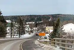
The primary settlement in the town is the village of West Stewartstown on U.S. Route 3 along the Connecticut River, opposite the town of Canaan, Vermont. Stewartstown village is a mile northeast of West Stewartstown, along Route 3 and opposite the village of Beecher Falls, Vermont. To the east, the village of Stewartstown Hollow is closer to the geographic center of the town, along New Hampshire Route 145.
Demographics
| Historical population | |||
|---|---|---|---|
| Census | Pop. | %± | |
| 1800 | 99 | — | |
| 1810 | 186 | 87.9% | |
| 1820 | 363 | 95.2% | |
| 1830 | 129 | −64.5% | |
| 1840 | 630 | 388.4% | |
| 1850 | 747 | 18.6% | |
| 1860 | 771 | 3.2% | |
| 1870 | 909 | 17.9% | |
| 1880 | 958 | 5.4% | |
| 1890 | 1,002 | 4.6% | |
| 1900 | 1,150 | 14.8% | |
| 1910 | 1,128 | −1.9% | |
| 1920 | 1,109 | −1.7% | |
| 1930 | 1,148 | 3.5% | |
| 1940 | 1,203 | 4.8% | |
| 1950 | 970 | −19.4% | |
| 1960 | 918 | −5.4% | |
| 1970 | 1,008 | 9.8% | |
| 1980 | 943 | −6.4% | |
| 1990 | 1,048 | 11.1% | |
| 2000 | 1,012 | −3.4% | |
| 2010 | 1,004 | −0.8% | |
| 2017 (est.) | 934 | [4] | −7.0% |
| U.S. Decennial Census[5] | |||
At the 2000 census there were 1,012 people, 371 households, and 241 families living in the town. The population density was 21.8 people per square mile (8.4/km2). There were 760 housing units at an average density of 16.4 per square mile (6.3/km2). The racial makeup of the town was 99.11% White, 0.10% Native American, and 0.79% from two or more races. Hispanic or Latino of any race were 0.10%.[6]
Of the 371 households 31.5% had children under the age of 18 living with them, 50.4% were married couples living together, 7.8% had a female householder with no husband present, and 34.8% were non-families. 27.8% of households were one person and 9.7% were one person aged 65 or older. The average household size was 2.42 and the average family size was 2.91.
The age distribution was 23.1% under the age of 18, 7.5% from 18 to 24, 27.3% from 25 to 44, 24.4% from 45 to 64, and 17.7% 65 or older. The median age was 39 years. For every 100 females, there were 106.1 males. For every 100 females age 18 and over, there were 106.9 males.
The median household income was $30,700 and the median family income was $34,911. Males had a median income of $29,286 versus $21,313 for females. The per capita income for the town was $17,231. About 9.0% of families and 11.5% of the population were below the poverty line, including 12.3% of those under age 18 and 14.4% of those age 65 or over.
Notable residents
- Metallak, Androscoggin elder[7][8] (burial place)
See also
- New Hampshire Historical Marker No. 47: Metallak
- New Hampshire Historical Marker No. 64: 45th Parallel
References
- United States Census Bureau, American FactFinder, 2010 Census figures. Retrieved March 23, 2011.
- "Geographic Identifiers: 2010 Demographic Profile Data (G001) - Stewartstown town, New Hampshire". United States Census Bureau. Retrieved November 9, 2011.
- "Annual Estimates of the Resident Population: April 1, 2010 to July 1, 2017 (PEPANNRES): Minor Civil Divisions – New Hampshire". Archived from the original on February 13, 2020. Retrieved November 14, 2018.
- "Census of Population and Housing". Census.gov. Retrieved June 4, 2016.
- "U.S. Census website". United States Census Bureau. Retrieved 2008-01-31.
- Woodrow, Arthur D (1928). "Metallak, last of the Cooashaukes: with the life of David Robbins, the story of Molly Ockett, the adventures of Lieut. Segar and the killing of the last moose". archive.org. Retrieved 2017-12-04.
- Vincente, Anthony (2016). "Magnificent Tales of Metallak – NH State Parks". blog.nhstateparks.org. Retrieved 2017-12-05.
External links
| Wikimedia Commons has media related to Stewartstown, New Hampshire. |
Places adjacent to Stewartstown, New Hampshire | |
|---|---|
Municipalities and communities of Coös County, New Hampshire, United States | ||
|---|---|---|
| City | 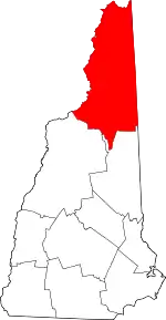 Map of New Hampshire highlighting Coos County | |
| Towns | ||
| Townships |
| |
| CDPs | ||
| Other communities | ||
| ||