Sulop
Sulop, officially the Municipality of Sulop (Cebuano: Lungsod sa Sulop; Tagalog: Bayan ng Sulop), is a 3rd class municipality in the province of Davao del Sur, Philippines. According to the 2015 census, it has a population of 33,613 people. [3]
Sulop | |
|---|---|
| Municipality of Sulop | |
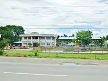
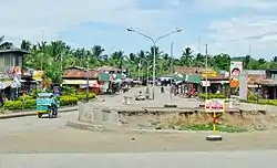 Downtown area | |
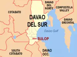 Map of Davao del Sur with Sulop highlighted | |
OpenStreetMap 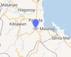
| |
.svg.png.webp) Sulop Location within the Philippines | |
| Coordinates: 6°35′55″N 125°20′37″E | |
| Country | |
| Region | Davao Region (Region XI) |
| Province | Davao del Sur |
| District | Lone District |
| Barangays | 25 (see Barangays) |
| Government | |
| • Type | Sangguniang Bayan |
| • Mayor | Jose Jimmy S. Sagarino |
| • Vice Mayor | Willie S. Villegas |
| • Representative | Mercedes C. Cagas |
| • Electorate | 23,181 voters (2019) |
| Area | |
| • Total | 155.26 km2 (59.95 sq mi) |
| Elevation | 77 m (253 ft) |
| Population | |
| • Total | 33,613 |
| • Density | 220/km2 (560/sq mi) |
| • Households | 8,550 |
| Economy | |
| • Income class | 3rd municipal income class |
| • Poverty incidence | 21.42% (2015)[4] |
| • Revenue | ₱100,460,170.39 (2016) |
| Time zone | UTC+8 (PST) |
| ZIP code | 8009 |
| PSGC | |
| IDD : area code | +63 (0)82 |
| Climate type | tropical rainforest climate |
| Native languages | Davawenyo Cebuano Kalagan Tagalog Ata Manobo |
| Website | www |
Geography
Sulop is about 17 kilometres (11 mi) from Digos City, the seat of the provincial government of Davao del Sur. The municipality is located halfway between two major growth centers of Mindanao, namely, Davao City of Region XI and General Santos City of Region XII.
Barangays
Sulop is politically subdivided into 25 barangays.
- Balasinon
- Buguis
- Carre
- Clib
- Harada Butai
- Katipunan
- Kiblagon
- Labon
- Laperas
- Lapla
- Litos
- Luparan - Kuyaw ni bay!
- Mckinley
- New Cebu
- Osmeña
- Palili
- Parame
- Poblacion
- Roxas
- Solongvale
- Tagolilong
- Tala-o
- Talas
- Tanwalang
- Waterfall
Climate
| Climate data for Sulop, Davao del Sur | |||||||||||||
|---|---|---|---|---|---|---|---|---|---|---|---|---|---|
| Month | Jan | Feb | Mar | Apr | May | Jun | Jul | Aug | Sep | Oct | Nov | Dec | Year |
| Average high °C (°F) | 30 (86) |
30 (86) |
31 (88) |
32 (90) |
31 (88) |
30 (86) |
29 (84) |
30 (86) |
30 (86) |
30 (86) |
30 (86) |
30 (86) |
30 (87) |
| Average low °C (°F) | 23 (73) |
23 (73) |
23 (73) |
24 (75) |
24 (75) |
24 (75) |
24 (75) |
24 (75) |
24 (75) |
24 (75) |
24 (75) |
23 (73) |
24 (74) |
| Average precipitation mm (inches) | 59 (2.3) |
46 (1.8) |
41 (1.6) |
54 (2.1) |
105 (4.1) |
159 (6.3) |
179 (7.0) |
197 (7.8) |
162 (6.4) |
147 (5.8) |
102 (4.0) |
65 (2.6) |
1,316 (51.8) |
| Average rainy days | 12.3 | 11.7 | 12.2 | 14.5 | 22.6 | 25.6 | 26.6 | 27.5 | 25.5 | 26.0 | 21.2 | 16.0 | 241.7 |
| Source: Meteoblue [5] | |||||||||||||
History
The name Sulop, derived from native languages, means "swampy place surrounded by second growth forest" and "habitat of wild pigs."
In the early part of the 19th century, a wave of immigrants from the Visayas Region, mostly from Cebu, came to Sulop. At the time, Sulop was still a barangays under the Municipality of Padada, Davao del Sur. Settlers from Leyte, Iloilo, and Bohol also arrived during the century. They acquired lands from natives peoples known as the Tagacaolo, the B’laans, and the Bagobos, and converted the lands into settlement sites and agricultural production areas.
By virtue of Executive Order No. 295 issued on April 24, 1958, President Carlos P. Garcia converted barangays Sulop and its adjacent barangays into an independent Municipality of Sulop of the Province of Davao del Sur. The development of the municipality underwent eight changes of political leadership up to the present Administration.
President Carlos P Garcia appointed Nestorio Comabig as the first mayor of the Municipality of Sulop. Comabig assigned residential lots to interested parties consistent with the town site development plan. Comabig resigned from office after six years, after which Vice Mayor Antonio Go Pace assumed the vacated mayoral position. He facilitated the construction of the first municipality’s Town Hall.
Vice Mayor Sebastian Mondejar, Sr. succeeded the mayorship of Go Pace when the latter died. Mondejar facilitated the coming of Cocoa Investors, Incorporated (CII), a multi-million peso corporation engaged in cacao bean production.
Vice Mayor Perfecto O. Sagarino Sr. succeeded as mayor when Mayor Sebastian Mondejar Sr. was killed in an ambush on December 3, 1982, during the height of insurgency. Sagarino's greatest achievement was the construction of Sulop Public Market Buildings. He relinquished his position after the EDSA Revolution (People Power Revolution) in 1986;
Atty. Leopoldo C. Diones, Jr. was then installed as OIC-Mayor who retained his position by winning the 1987 and 1992 elections.
Atty. Jose Jimmy S. Sagarino, son of former mayor Perfecto O. Sagarino, emerged the winner in the mayoralty race in 1995 and stayed on for 3 terms. The construction of the new Municipal Government Center of Sulop was made during his incumbency.
On June 30, 2004, local leadership was then steered by Mayor Restituto Ornales. He placed agricultural productivity as the centerpiece of his development thrust and initiated the construction of Labon – Clib Steel Bridge.
The latest change in leadership took place on June 30, 2007, when Mayor Jose Jimmy S. Sagarino was re-elected to his fourth term in office. In his new term, he celebrated the Golden Founding Anniversary of the Municipality of Sulop.
Demographics
| Year | Pop. | ±% p.a. |
|---|---|---|
| 1960 | 28,385 | — |
| 1970 | 22,762 | −2.18% |
| 1975 | 22,014 | −0.67% |
| 1980 | 23,094 | +0.96% |
| 1990 | 24,513 | +0.60% |
| 1995 | 25,968 | +1.09% |
| 2000 | 27,340 | +1.11% |
| 2007 | 29,082 | +0.86% |
| 2010 | 32,163 | +3.73% |
| 2015 | 33,613 | +0.84% |
| Source: Philippine Statistics Authority [3] [6] [7][8] | ||
Education
The Southern Philippines Agri-business and Marine and Aquatic School of Technology (SPAMAST) has a Sulop Extension.
References
- Municipality of Sulop | (DILG)
- "Province: Davao del Sur". PSGC Interactive. Quezon City, Philippines: Philippine Statistics Authority. Retrieved 12 November 2016.
- Census of Population (2015). "Region XI (Davao Region)". Total Population by Province, City, Municipality and Barangay. PSA. Retrieved 20 June 2016.
- "PSA releases the 2015 Municipal and City Level Poverty Estimates". Quezon City, Philippines. Retrieved 12 October 2019.
- "Sulop: Average Temperatures and Rainfall". Meteoblue. Retrieved 28 January 2020.
- Census of Population and Housing (2010). "Region XI (Davao Region)". Total Population by Province, City, Municipality and Barangay. NSO. Retrieved 29 June 2016.
- Censuses of Population (1903–2007). "Region XI (Davao Region)". Table 1. Population Enumerated in Various Censuses by Province/Highly Urbanized City: 1903 to 2007. NSO.
- "Province of Davao del Sur". Municipality Population Data. Local Water Utilities Administration Research Division. Retrieved 17 December 2016.
External links
| Wikimedia Commons has media related to Sulop, Davao del Sur. |
- Sulop Profile at PhilAtlas.com
- Philippine Standard Geographic Code
- Philippine Census Information
- Local Governance Performance Management System
Places adjacent to Sulop | ||||||||||
|---|---|---|---|---|---|---|---|---|---|---|
| ||||||||||
Digos (capital) | |
| Municipalities | |
| Component City | |
| Highly urbanized city |
|
