Matanao
Matanao, officially the Municipality of Matanao (Cebuano: Lungsod sa Matanao; Tagalog: Bayan ng Matanao), is a 2nd class municipality in the province of Davao del Sur, Philippines. According to the 2015 census, it has a population of 56,755 people. [3]
Matanao | |
|---|---|
| Municipality of Matanao | |
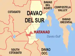 Map of Davao del Sur with Matanao highlighted | |
OpenStreetMap 
| |
.svg.png.webp) Matanao Location within the Philippines | |
| Coordinates: 6°45′N 125°14′E | |
| Country | |
| Region | Davao Region (Region XI) |
| Province | Davao del Sur |
| District | Lone District |
| Barangays | 33 (see Barangays) |
| Government | |
| • Type | Sangguniang Bayan |
| • Mayor | Vincent F. Fernandez |
| • Vice Mayor | Alfredo O. Panerio |
| • Representative | Mercedes C. Cagas |
| • Electorate | 37,817 voters (2019) |
| Area | |
| • Total | 202.40 km2 (78.15 sq mi) |
| Elevation | 64 m (210 ft) |
| Population | |
| • Total | 56,755 |
| • Density | 280/km2 (730/sq mi) |
| • Households | 13,787 |
| Economy | |
| • Income class | 2nd municipal income class |
| • Poverty incidence | 25.14% (2015)[4] |
| • Revenue | ₱131,169,990.51 (2016) |
| Time zone | UTC+8 (PST) |
| ZIP code | 8003 |
| PSGC | |
| IDD : area code | +63 (0)82 |
| Climate type | tropical rainforest climate |
| Native languages | Davawenyo Cebuano Kalagan Tagalog Ata Manobo |
| Website | www |
Matanao is bordered in the west by the town of Columbio, in the province of Sultan Kudarat, in the north by the towns of Magsaysay and Bansalan, in the east by Hagonoy and the city of Digos, and in the south by Kiblawan and Padada.
History
In 1957, some of the barrios of the municipality of Bansalan namely Kibao, San Vicente, Kibuaya, Managa Km. 67, Sinawilan, New Visayas, Sacub, Upper Malabang, Tibongbong, Sinaragan, Maliit Digos, Kapok, Tamlangon, Manga, Buas, New Katipunan, Da-Anama, Upper Kauswagan, Kagaulas, Kabasagan, Tuwak, Mal, Latian, Lanturi, Dongan-Pekong, La Union, Kauswagan, and Paitan were grouped and constituted into a new and independent municipality known as Matanao.[5]
Matanao means a place or something to see or witness at a vantage point. In the earlier days, the place was known as “Matin-aw”, a term used to mean clear. The name is derived from the crystal clear brooks and rivers that abound in the area. No one could exactly tell how, when and why “Matin-aw” became Matanao.
In 1920, long before Matanao was formally created into a municipality, Buas had already existed (representing Matanao) as a barangay of Santa Cruz inhabited by tribal minorities, the Blaans (Bilaan) with Datu Edu Gamban as their recognized leader. In 1927, migrants from the Visayas led by the late Rosendo Javelona and his family came to the place. Protestantism was spread by one Pastor Diamonon through the Javelonas. Ranchers also invaded the place and have for themselves large homesteads. Ten years later, sometime in 1937, scores of Cebuanos came. Among them were Roman Albarracin, Pablo Chavez and Crispin Puerto and their kins. The next batch of Cebuanos came in 1940′s including the Famor Clan. The clan introduced Catholicism in the area and a chapel was built giving honor to the present patron Saint Senor San Miguel, the Archangel.
Countless batches of migrants flocked to the place and various cultural influences account for what Matanao is today. The people of the municipality is a blend of Cebuanos, Ilongos, Bicolanos, Boholanos, Ilocanos, Zamboanguenos, Tagalogs, Blaans, Calagans and Bagobos, Babel of dialects was experienced by the people in the place, but Cebuano came out to be the dominating dialect, thus, becoming the mother tongue of the municipality until the present time.
Geography
Matanao is located in the province of Davao Del Sur in Region XI Davao Region on Mindanao Island. The municipality Matanao is about 15 kilometres (9.3 mi) west-south-west of province capital City Of Digos and about 990 kilometres (620 mi) south-south-east of Philippine main capital Manila.
Climate
Hot and humid most of the year. May to November is typhoon season. The mean annual temperature of the municipality is between 22.4 to 31.5 °C (72.3 to 88.7 °F). The annual rainfall ranges from 1,500 to 2,500 millimetres (59 to 98 in). The coldest part of the year is usually during the month of December to February and the hottest month are April and May. Rainfall distribution is more or less even during the year.
| Climate data for Matanao, Davao del Sur | |||||||||||||
|---|---|---|---|---|---|---|---|---|---|---|---|---|---|
| Month | Jan | Feb | Mar | Apr | May | Jun | Jul | Aug | Sep | Oct | Nov | Dec | Year |
| Average high °C (°F) | 30 (86) |
30 (86) |
31 (88) |
32 (90) |
31 (88) |
30 (86) |
29 (84) |
30 (86) |
30 (86) |
30 (86) |
30 (86) |
30 (86) |
30 (87) |
| Average low °C (°F) | 23 (73) |
23 (73) |
23 (73) |
23 (73) |
24 (75) |
24 (75) |
24 (75) |
24 (75) |
24 (75) |
24 (75) |
23 (73) |
23 (73) |
24 (74) |
| Average precipitation mm (inches) | 59 (2.3) |
46 (1.8) |
41 (1.6) |
54 (2.1) |
105 (4.1) |
159 (6.3) |
179 (7.0) |
197 (7.8) |
162 (6.4) |
147 (5.8) |
102 (4.0) |
65 (2.6) |
1,316 (51.8) |
| Average rainy days | 12.3 | 11.7 | 12.2 | 14.5 | 22.6 | 25.6 | 26.6 | 27.5 | 25.5 | 26.0 | 21.2 | 16.0 | 241.7 |
| Source: Meteoblue [6] | |||||||||||||
Barangays
Matanao is politically subdivided into 33 barangays. The poblacion forms the center of the municipality whereas the other 32 are in the outlying areas which several kilometers away from the town.
| Barangays | PSG-Code | Urban/rural | Population (2010) |
|---|---|---|---|
| Asbang | 112410001 | rural | 1,082 |
| Asinan | 112410002 | rural | 623 |
| Bagumbayan | 112410003 | rural | 470 |
| Bangkal | 112410004 | rural | 3,136 |
| Buas | 112410005 | rural | 836 |
| Buri | 112410006 | rural | 2,318 |
| Camanchiles | 112410007 | rural | 1,218 |
| Ceboza | 112410008 | rural | 618 |
| Colonsabak | 112410009 | rural | 1,619 |
| Dongan-Pekong | 112410010 | rural | 1,536 |
| Kabasagan | 112410012 | rural | 2,034 |
| Kapok | 112410013 | rural | 1,151 |
| Kauswagan | 112410014 | rural | 1,474 |
| Kibao | 112410015 | rural | 617 |
| La Suerte | 112410016 | rural | 1,685 |
| Langa-an | 112410017 | rural | 665 |
| Lower Marber | 112410019 | rural | 1,309 |
| Cabligan (Managa) | 112410021 | rural | 1,492 |
| Manga | 112410022 | rural | 3,569 |
| New Katipunan | 112410023 | rural | 1,909 |
| New Murcia | 112410024 | rural | 1,321 |
| New Visayas | 112410025 | rural | 2,367 |
| Poblacion | 112410026 | urban | 4,969 |
| Saboy | 112410027 | rural | 1,730 |
| San Jose | 112410028 | rural | 1,128 |
| San Miguel | 112410029 | rural | 501 |
| San Vicente | 112410030 | rural | 732 |
| Saub | 112410031 | rural | 467 |
| Sinaragan | 112410032 | rural | 1,448 |
| Sinawilan | 112410033 | rural | 4,016 |
| Tamlangon | 112410034 | rural | 782 |
| Towak | 112410035 | rural | 1,793 |
| Tibongbong | 112410036 | rural | 767 |
Demographics
|
| ||||||||||||||||||||||||||||||||||||
| Source: Philippine Statistics Authority [3] [7] [8][9] | |||||||||||||||||||||||||||||||||||||
Economy
Although predominantly a rice farming municipality, Matanao is a growing area for banana cultivation. Cavendish and Lakatan banana plantations are now being established in barangays Manga, Dongan-Pekong and Saboy.
References
- Municipality of Matanao | (DILG)
- "Province: Davao del Sur". PSGC Interactive. Quezon City, Philippines: Philippine Statistics Authority. Retrieved 12 November 2016.
- Census of Population (2015). "Region XI (Davao Region)". Total Population by Province, City, Municipality and Barangay. PSA. Retrieved 20 June 2016.
- "PSA releases the 2015 Municipal and City Level Poverty Estimates". Quezon City, Philippines. Retrieved 12 October 2019.
- "An Act Creating the Municipality of Matanao, Province of Davao". LawPH.com. Archived from the original on 2012-07-10. Retrieved 2011-04-12.
- "Matanao: Average Temperatures and Rainfall". Meteoblue. Retrieved 28 January 2020.
- Census of Population and Housing (2010). "Region XI (Davao Region)". Total Population by Province, City, Municipality and Barangay. NSO. Retrieved 29 June 2016.
- Censuses of Population (1903–2007). "Region XI (Davao Region)". Table 1. Population Enumerated in Various Censuses by Province/Highly Urbanized City: 1903 to 2007. NSO.
- "Province of Davao del Sur". Municipality Population Data. Local Water Utilities Administration Research Division. Retrieved 17 December 2016.
External links
- Matanao Profile at PhilAtlas.com
- Philippine Standard Geographic Code
- Philippine Census Information
- Local Governance Performance Management System
Places adjacent to Matanao | |
|---|---|
Digos (capital) | |
| Municipalities | |
| Component City | |
| Highly urbanized city |
|