Digos
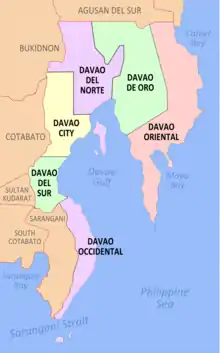
Digos, officially the City of Digos (Cebuano: Dakbayan sa Digos; Tagalog: Lungsod ng Digos), is a 2nd class component city and capital of the province of Davao del Sur, Philippines. According to the 2015 census, it has a population of 169,393 people. [3]
Digos | |
|---|---|
| City of Digos | |
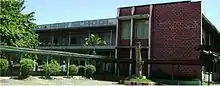
.JPG.webp) City Hall | |
 Seal | |
Nicknames:
| |
| Motto(s): Abante Digos! | |
 Map of Davao del Sur with Digos highlighted | |
OpenStreetMap 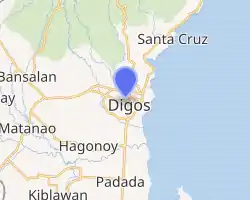
| |
.svg.png.webp) Digos Location within the Philippines | |
| Coordinates: 6°45′N 125°21′E | |
| Country | |
| Region | Davao Region (Region XI) |
| Province | Davao del Sur |
| District | Lone District |
| Founded | 19 July 1949 |
| Cityhood | 8 September 2000 |
| Barangays | 26 (see Barangays) |
| Government | |
| • Type | Sangguniang Panlungsod |
| • Mayor | Josef F. Cagas |
| • Vice Mayor | Johari G. Baña |
| • Representative | Mercedes C. Cagas |
| Area | |
| • Total | 287.10 km2 (110.85 sq mi) |
| Elevation | 190 m (620 ft) |
| Population | |
| • Total | 169,393 |
| • Density | 590/km2 (1,500/sq mi) |
| • Households | 41,299 |
| Demonym(s) | Digoseño |
| Economy | |
| • Income class | 2nd city income class |
| • Poverty incidence | 14.18% (2015)[4] |
| • Revenue | ₱728,768,279.59 (2016) |
| Time zone | UTC+8 (PST) |
| ZIP code | 8002 |
| PSGC | |
| IDD : area code | +63 (0)82 |
| Climate type | tropical rainforest climate |
| Native languages | Davawenyo Cebuano Obo language Kalagan Tagalog Ata Manobo |
| Website | www |
The city lies on the western shores of the Davao Gulf and southern foothills of Mount Apo on the island of Mindanao, centrally located between the three major cities in Mindanao, Davao City in the north, General Santos City in the south and Cotabato City in the west.
It is considered as part of Metropolitan Davao.
It is known for its sweet-juicy 'carabao variety mango,' sold locally and exported abroad, thus being dubbed as the Mango Capital City of the Philippines. It is also considered as The Gate City Of The South.
On 8 September 2000, Digos was converted into a city.[5]
History
In the early days, Digos was a watercourse, a meeting place of inhabitants belonging to the Austronesians who settled along the southern foothills of Mt. Apo. The Digos River meets the Davao Gulf and it is ideal for fishing and bathing.
During the Spanish Era, a group of natives carrying bows and arrows were approached by some Spaniards traversing the very fertile tracts of land in Davao. One Lopez Jaena Pacheco, a conquistador during the administration of Governor Claveria serving as the head of the group, inquired about the name of the place from the barefooted natives. Believing that the Spaniards were asking where they were bound to, the natives answered "Padigus", which means "to take a bath". Since then the place was identified as Digos.
As a portion of the "food bowl" of the province of Davao del Sur, otherwise known as the Padada Valley, Digos lured many migrants, majority of whom came from the Visayas and Ilocos regions to settle permanently in the area. Before World War II, an enterprising American by the name of N.E. Crumb leased 10.24 km² and transformed the place into an Abaca Plantation. This became the hub of economic activity in the locality during those days.
Digos was occupied by the Japanese troops in 1942.
In 1945, through the brave efforts of the combined forces of the Philippine Commonwealth Army, the local Davaoeño guerrilla units from the Davao peninsula, and the United States military, the Japanese soldiers were defeated.
Through the initiation of then Congressman Apolinario Cabigon, Digos, became a regular municipality in 1949 by virtue of Presidential Executive Order No. 236, dated July 19, 1949 issued by President Quirino. Its Coverage included the barrios of Tres de Mayo, Goma Bansalan, Matanao, Darapuay and the Poblacion where the seat of government was located. Before its creation into a municipality, Digos was a barrio of Santa Cruz, a town 16 kilometers away. On July 19, 1949, the town was formally inaugurated with Benito Rabor appointed as Mayor.
Digos in later years, before its conversion into a city, was regarded as the capital town of the Province of Davao del Sur, long before it gained the status of a First Class Municipality in 1993, being center for trade, commerce and education, accruing to its strategic location at the cross point of two principal thoroughfares in the south.
In July 1998, the bid to convert into a city was moved and initiated by Mayor Arsenio A. Latasa, considering its very satisfactory qualifications required for in R.A. 7160
House Bill No. 5672 dated November 24, 1998, of Congress authored by Congressman Douglas Ra. Cagas, led to the drafting of Republic Act 8798, converting the Municipality of Digos into a component City of Davao del Sur, which was signed by President Joseph E. Estrada on 14 July 2000, and ratified by the Digoseños on September 8, 2000.
Geography
Digos shares common boundaries with the municipalities of Hagonoy in the south, Bansalan in the north and northwest by Siranagan and Miral Creek and with Santa Cruz in the northeast. It is bounded in the east by the Davao Gulf. It has a total land area of 28,710 hectares (70,900 acres) consisting of 26 barangays; nine (9) of which comprise the poblacion or urban center.
The land topography of Digos City ranges from hilly to mountainous in the north-northeast portion and flat and slightly rolling at the coastal barangays, while the urban area and the surrounding barangays in the south portion are generally flat. Generally, climate in Digos falls under the fourth type while wind direction is prevalent from northeast to southwest. On the other hand, rainfall is evenly distributed throughout the year wherein during the period from 1995 to 2000, there was no observed extreme dry or wet season.
Barangays
Digos City is politically subdivided into 26 barangays.
| Barangay | Population (2007) | Population (2010) | Urban/Rural |
|---|---|---|---|
| Aplaya | 14,775 | 15,409 | Urban |
| Balabag | 1,206 | 1,226 | Rural |
| Binaton | 2,765 | 2,034 | Rural |
| Cogon | 5,559 | 5,993 | Rural |
| Colorado | 2,276 | 2,323 | Rural |
| Dawis | 4,244 | 4,584 | Urban |
| Dulangan | 1,592 | 1,329 | Rural |
| Goma | 3,469 | 3,676 | Rural |
| Igpit | 3,078 | 3,471 | Rural |
| Kiagot | 4,319 | 4,679 | Rural |
| Lungag | 286 | 567 | Rural |
| Mahayahay | 773 | 772 | Rural |
| Matti | 5,093 | 5,328 | Urban |
| Kapatagan (Rizal) | 8,403 | 10,162 | Urban |
| Ruparan | 3,175 | 2,873 | Rural |
| San Agustin | 1,895 | 2,143 | Rural |
| San Jose (Balutakay) | 5,419 | 6,072 | Urban |
| San Miguel (Odaca) | 12,148 | 13,813 | Urban |
| San Roque | 839 | 951 | Rural |
| Sinawilan | 4,820 | 4,539 | Rural |
| Soong | 1,140 | 1,277 | Rural |
| Tiguman | 1,239 | 1,625 | Rural |
| Tres de Mayo | 14,590 | 15,475 | Urban |
| Zone 1 (Pob) | 14,052 | 13,754 | Urban |
| Zone 2 (Pob) | 9,439 | 8,071 | Urban |
| Zone 3 (Pob) | 18,920 | 17,745 | Urban |
Demographics
|
| ||||||||||||||||||||||||||||||||||||
| Source: Philippine Statistics Authority [3] [6] [7][8] | |||||||||||||||||||||||||||||||||||||
Climate
| Climate data for Digos City | |||||||||||||
|---|---|---|---|---|---|---|---|---|---|---|---|---|---|
| Month | Jan | Feb | Mar | Apr | May | Jun | Jul | Aug | Sep | Oct | Nov | Dec | Year |
| Average high °C (°F) | 30 (86) |
30 (86) |
31 (88) |
32 (90) |
31 (88) |
30 (86) |
29 (84) |
30 (86) |
30 (86) |
30 (86) |
30 (86) |
29 (84) |
30 (86) |
| Average low °C (°F) | 23 (73) |
23 (73) |
23 (73) |
24 (75) |
24 (75) |
24 (75) |
24 (75) |
24 (75) |
24 (75) |
24 (75) |
23 (73) |
22 (72) |
24 (74) |
| Average precipitation mm (inches) | 59 (2.3) |
46 (1.8) |
41 (1.6) |
54 (2.1) |
105 (4.1) |
159 (6.3) |
179 (7.0) |
197 (7.8) |
162 (6.4) |
147 (5.8) |
102 (4.0) |
65 (2.6) |
1,316 (51.8) |
| Average rainy days | 12.3 | 11.7 | 12.2 | 14.5 | 22.6 | 25.6 | 26.6 | 27.5 | 25.5 | 26.0 | 21.2 | 16.0 | 241.7 |
| Source: Meteoblue [9] | |||||||||||||
Economy
Agriculture is a major component of Digos City economy. Some 9,330 households or 37% of the total households are dependent on agriculture for their livelihood. Of the total households dependent on agriculture, 91% are engaged in farming and the remaining 9% in fishing. The total area devoted to agriculture covered 8, 944.1 hectares, representing 31% of the total land area of Digos. The more important agricultural crops grown in the area include coconut, sugarcane, mango and banana. Among the agricultural crops, the staple crops rice and corn are the most widely grown.
Local government
Elected officials 2019-2021:
- Mayor: Josef Cagas
- Vice Mayor: Johari Bana
Fiestas and festivals
- Sinulog sa Digos - every January 15
- San Isidrio Labrador - every May 15
- Padigosan Festival - every July 19
- Mary Mediatrix - every August 22
- Araw ng Digos - every September 8
- GKK/BEC (Gagmay'ng Kristohanong Katilingban/Basic Ecclessial Community) Fiestas - Depends on the feast day of the patron saint.
Infrastructure
Transportation
Local means of transportation is served by almost 5,000 tricycles known locally as just "Pedicab". Transportation to its barangays and adjacent municipalities are served by single Motorcycles (SKYLAB/HABAL-HABAL), Multicabs, Jeepneys, and L300 Vans. Public Utility Vans also served routes to and from the cities of Davao, Cotabato, Kidapawan, Tacurong-Isulan, Koronadal and General Santos.
Bus Company operating in the city of Digos:
- Mindanao Star (General Santos City, Davao City & Cotabato City)
- Davao Metro Shuttle (Tagum City)
- Yellow Bus Lines Inc. (General Santos City/Koronadal City)
- Grand Transport Corp. (Tacurong City)
- SEMTRAMPCO (Digos City)
- Tacurong Express (Tacurong City)
- Davao ACF Bus Line (Malita, Davao del Sur)
Hospitals/healthcare facilities
- Digos Doctors Hospital
- CM Torregosa Birthing Home and Woman Center
- Medical Center Of Digos Cooperative
- Gonzales-Maranan Clinics & Hospital
- Davao Del Sur Provincial Hospital
- Dominican Hospital
- Sunga Hospital
- Llanos Medical Clinic & Hospital
- Paulino Hospital
- Masong-song Clinic & Hospital
- Davao Del Sur Medical Specialist
- Digos Medical Multi-test
- Bethlehem Birthing Center
- Monarca Lying Inn Clinic
- Mayor's Birthing Place
- Kayden-Blaise Birthing Home
Education
Public and private schools in Digos City:
Tertiary
- Cor Jesu College (private, catholic)
- University of Mindanao Digos Campus (private, non-sectarian)
- Polytechnic College of Davao del Sur (private)
- Southern Philippines Agri-Business and Marine and Aquatic School of Technology (SPAMAST) - Digos Campus (public)
- John Paul II Seminary (theological school, Diocese of Digos)
- PRIME Innovations, Technical and Vocational School [PITVS] (Private, Non-Sectarian)
- Southern Mindanao Computer College (private)
- Philippine International Technological School (private)
- Adventure College Of Technology And Science (private)
- Mindanao Technological Institute (private)
- Digital Systems Institute (private)
- Digos Institute Of Technical Education (private)
Secondary
- Cor Jesu College High School Department
- Digos City National High School
- Holy Cross Academy Inc.
- The Lighthouse Accelerated Christian School
- Polytechnic College of Davao del Sur High School Department
- Digos City National High School Igpit Extension
- Kapatagan National High School
- Aplaya National High School
- Ruparan National High School
- Digos City National High School Soong Extension
- Igpit National High School
- Digos City National High School - Balabag High School Annex
- Digos Central Adventist Academy - Lapu lapu Ext.
- Matti National High School
Notable people
References
- City of Digos | (DILG)
- "Province: Davao del Sur". PSGC Interactive. Quezon City, Philippines: Philippine Statistics Authority. Retrieved 12 November 2016.
- Census of Population (2015). "Region XI (Davao Region)". Total Population by Province, City, Municipality and Barangay. PSA. Retrieved 20 June 2016.
- "PSA releases the 2015 Municipal and City Level Poverty Estimates". Quezon City, Philippines. Retrieved 12 October 2019.
- NSCB - 2001 Factsheet - 12 New Cities Created Archived April 23, 2006, at the Wayback Machine, July–December 2000.
- Census of Population and Housing (2010). "Region XI (Davao Region)". Total Population by Province, City, Municipality and Barangay. NSO. Retrieved 29 June 2016.
- Censuses of Population (1903–2007). "Region XI (Davao Region)". Table 1. Population Enumerated in Various Censuses by Province/Highly Urbanized City: 1903 to 2007. NSO.
- "Province of Davao del Sur". Municipality Population Data. Local Water Utilities Administration Research Division. Retrieved 17 December 2016.
- "Digos: Average Temperatures and Rainfall". Meteoblue. Retrieved 28 January 2020.
- Karlo Sacamos (25 April 2019). "Scottie bought Digos lot with first Ginebra paycheck. His dream house now sits there". Spin.ph. Sports Interactive Network (SPIN.PH). Retrieved 6 January 2020.
External links
| Wikivoyage has a travel guide for Digos. |
| Wikimedia Commons has media related to Digos City. |
- Digos Profile at PhilAtlas.com
- Philippine Standard Geographic Code
- Local Governance Performance Management System
Places adjacent to Digos | ||||||||||
|---|---|---|---|---|---|---|---|---|---|---|
| ||||||||||
| Authority control |
|---|